Download
1 / 55
560 likes | 1.08k Vues
Geographic Mapping of SARS. Maged N Kamel Boulos PhD , MSc, MBBCh School for Health/ Institute of Health & Medicine University of Bath Claverton Down, Bath BA2 7AY, UK E-mail: M.N.K.Boulos@bath.ac.uk.

E N D
Geographic Mapping of SARS Maged N Kamel BoulosPhD, MSc, MBBCh School for Health/ Institute of Health & Medicine University of Bath Claverton Down, Bath BA2 7AY, UK E-mail: M.N.K.Boulos@bath.ac.uk Based on: Kamel Boulos MN. Geographic Mapping of SARS. Presented at the “Epidemiology: A Spatial Perspective” meeting organised by Telford Institute of Environmental Systems with the backing of the Remote Sensing and Photogrammetry Society, University of Salford, Greater Manchester, UK, 17 June 2003 [http://www.ties.salford.ac.uk/epimeet/meeting.htm] Revision 3 (28 June 2003)
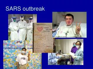
A Tribute to the Late Dr Carlo Urbani On 29 March 2003, Dr Carlo Urbani, an expert on communicable diseases, died of Severe Acute Respiratory Syndrome (SARS). Dr Urbani was the first World Health Organization (WHO) officer to identify the outbreak of this new disease, in an American businessman who had been admitted to a hospital in Hanoi, Vietnam. Because of his early detection of SARS, global surveillance was heightened and many new cases have been identified and isolated before they infected hospital staff. Dr Urbani’s Photo and Text Source: WHO Dr Carlo Urbani(born 19 October 1956; died 29 March 2003)
Agenda: Main Points • Introduction • SARS—the First Major New Infectious Disease of the 21st Century • The Role of Geoinformatics in Epidemics • Web-based SARS Datasets and Maps: Availability and Features • Examples of Geographic Mapping of SARS • WHO • Corda Technologies • MapAsia.com • ESRI China (Hong Kong) • Hong Kong Yellow Pages • A SARS Mobile Location-based Service • Other Maps • What Else Can Be Done? (SarsNet) • Conclusion
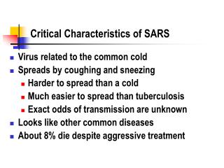
SARS—the First Major New Infectious Disease of the 21st Century • Severe Acute Respiratory Syndrome (SARS) is a highly infectious and potentially lethal atypical form of pneumonia that begins with deceiving common flu-like symptoms. • On 16 November 2002, the first known case of SARS was discovered in Guangdong province in southern China. Since then the disease has spread rapidly along international air routes to other parts of the world. • The number of reported SARS cases has increased exponentially, prompting the World Health Organization (WHO) to issue a global alert on 12 March 2003.
SARS—the First Major New Infectious Disease of the 21st Century • A novel coronavirus is the causative agent of SARS (Ksiazek et al. 2003). A medical staff member takes the temperature of a passenger at Hong Kong International Airport. SARS Coronavirus. Source: Department of Microbiology, the University of Hong Kong and the Government Virus Unit, Department of Health, Hong Kong SAR China.
SARS—the First Major New Infectious Disease of the 21st Century • All around the world, SARS has negatively affected every aspect of daily life: economic, social, travel, work, at school and home, etc. • For example, the WHO is now recommending* that persons planning to travel to risky destinations consider postponing their travel, while the Royal College of Surgeons of Edinburgh states in its policy statement on SARS: “Any traveller who has been in an area identified by WHO as a high risk area should not knowingly be accepted onto the College premises, or elsewhere on College business, for the time being, unless they can show evidence of having been away from these risk areas for a period of at least ten days without displaying any symptom of SARS.”*24 June 2003: WHO does not recommend the restriction of travel to any areas [http://www.who.int/csr/sars/travelupdate/en/]
The Role of Geoinformatics in Epidemics • Perhaps nothing is more inherently “geographical” than the study and control of epidemic spread at a variety of appropriate scales. • Geoinformatics is the science and technology of gathering, storing, visualising, analysing, interpreting, modelling, distributing and using spatially referenced (geographically referenced) information. • From geographic mapping at different scales to epidemiological modelling and location-based alerting services, geoinformatics plays an important role in the study and control of epidemics. This also applies to the latest global outbreak of SARS.
The Role of Geoinformatics in Epidemics • Geographic mapping of diseases dates back to the first maps used by Dr John Snow in 1854 to trace the origin of a cholera outbreak in Soho district, London. < Dr. John Snow (1813-1858), a legendary figure in the history of public health, epidemiology and anaesthesiology See: Kamel Boulos MN, Roudsari AV, Carson ER Health Geomatics: An Enabling Suite of Technologies in Health and Healthcare (Methodolical Review).J Biomed Inform2001, 34(3):195-219 - URL: [http://dx.doi.org/10.1006/jbin.2001.1015]
This map is a digital recreation of Dr Snow’s hand-drawn map. The 1854 cholera deaths are displayed as small black circles. The gray polygon represents the former burial plot of plague victims. The Broad Street pump (shown in the centre of the map) proved to be the source of contaminated water, just as Snow had hypothesised. Generated using CDC Epi Map 2000 for Windows, a public domain package that can be downloaded from [http://www.cdc.gov/epiinfo/]
The Role of Geoinformatics in Epidemics • Carefully planned and designed maps are powerful decision support and spatio-temporal analysis tools. • In the case of infectious disease epidemics, they allow public health decision makers, travellers and local populations at risk to visually monitor and appreciate at a glance changes, trends and patterns buried in large datasets that are continuously varying with time (like SARS datasets).
The Role of Geoinformatics in Epidemics • This kind of support is vital for making well-informed decisions when designing and following up epidemic control strategies or issuing and updating travel advisories. • As a matter of fact, during outbreak response, the WHO uses a custom-made geographic mapping technology, which forms part of its existing system for outbreak alert and response, to assist in the location of cases and rapid analysis of an epidemic’s dynamics. The WHO also uses this epidemiological mapping technology to predict environmental and climatic conditions conducive for some outbreaks.
Web-based SARS Datasets and Maps: Availability and Features • In this paper we review several geographic mapping efforts of SARS that we have found on the Internet. • The Internet is a unique source of reliable, up-to-date information on SARS compiled by the WHO and other official health bodies. • This includes the latest SARS case counts and lists of affected areas that form the basis of all the mapping examples reviewed in this paper.
Web-based SARS Datasets and Maps: Availability and Features Examples of frequently-updated SARS datasets on the Internet
Web-based SARS Datasets and Maps: Availability and Features • Web-based maps like those presented in this review offer the following extra features not found in conventional paper-based maps: • interactivity (e.g., drill-down and zooming, map querying, measuring distances, and switching map layers on and off); • capacity for quick, frequent map updates based on the latest datasets; and • wider dissemination/ availability to larger audiences.
Examples of Geographic Mapping of SARS: WHO • The WHO publishes a static, non-interactive map of the “cumulative number of reported probable cases” on its SARS Web site ([http://www.who.int/csr/sars/en/]). • Affected countries with no evidence of local SARS transmission are pink-coloured, while those where local SARS transmission is taking place are red-coloured. • The size of the graduated blue circle over an affected country reflects the cumulative number of reported cases in that country (countries with larger circles have more SARS cases).
The WHO’s map of the “cumulative number of reported probable SARS cases” as of 29 April 2003 ([http://www.who.int/csr/sars/map-2003_04_29.gif]).
WHO SARS Maps • More recently in May 2003, the WHO dropped the “type of transmission” from its daily world map of SARS and switched to a choropleth rendition (instead of graduated circles) to display the “number of current probable cases” (instead of the “cumulative number of reported probable cases”,which does not reflect the current situation). • The maps are produced by the WHO’s Public Health Mapping Team ([http://www.who.int/csr/mapping/en/]) and updated every 1-2 days. • The WHO also publishes graphical epidemic curves of SARS (see [http://www.who.int/csr/sarsepicurve/epiindex/en/]).
The WHO’s map of the “number of current probable SARS cases” as of 26 May 2003 ([http://www.who.int/csr/sars/map2003_05_26.gif]).
The WHO’s map of the “number of current probable SARS cases” as of 24June 2003 ([http://www.who.int/csr/sars/en/map2003_06_24.gif]).
WHO SARS Maps • On 13 June 2003, the WHO started publishing data and maps of current probable cases in China provided by the Chinese Ministry of Health. The WHO travel recommendations for China were also updated accordingly.
Corda Technologies • Corda Technologies, Inc. is a Utah (US) based developer of data visualisation solutions. • Corda’s SARS maps are not GIS (Geographic Information System)-driven. They are Macromedia Flash maps generated by Corda’s own interactive data visualisation engine (PopChartTM + OptiMapTM 5.0). • The maps are available online as a free public service intended to help educate visitors about SARS situation on a global and national (US) level ([http://www.corda.com/go/sars]). • Corda updates the maps every day or so, based on the latest figures from the WHO and CDC (US Centres for Disease Control and Prevention).
Corda’s world map of SARS displays data for each country affected by SARS. As the mouse moves over a country, a ToolTip appears with the cumulative number of reported cases. An accompanying graph shows SARS deaths by country. Users can also drill-down into the United States map to view how many cases have been reported in each state.
Corda Technologies • Cumulative numbers of SARS cases (including SARS recoveries and deaths since counts began) are mapped to individual countries, but not to actual regions/ areas within affected countries making the maps less useful to decision makers responsible for issuing travel advisories and travellers wanting to avoid risky areas. (The only exception is the US drill-down map, which shows SARS distribution by state though it still uses cumulative figures.) • Countries/ states with darker colour shades on Corda’s maps have more SARS cases (i.e., a choropleth rendition).
Corda Technologies • Corda’s world map of SARS could be greatly improved by also mapping the number of current SARS cases and by including affected area information for other parts of the world as they did for the United States (as second-level drill-down maps accessed by clicking respective countries on the main map). It is noteworthy that the WHO provides up-to-date SARS affected area information on its Web site ([http://www.who.int/csr/sarsareas/en/]). • Corda also provides a handy SARS worldwide infections/ recoveries/ deaths time line graph. The epidemic’s progress can be visually monitored and appreciated at a glance on this graph.
Corda’s SARS worldwide infections/ recoveries/ deaths time line graph.
MapAsia.com • MapAsia.com, a GIS company in Hong Kong, has published SARS distribution maps for Hong Kong and China on their MapInfo Discovery server—a GIS-driven Internet map server ([http://www.mapasia.com/sars/]). • The maps offer powerful zoom-in functionality (up to street/ building level on many of the maps). • A number of SARS map themes are provided and regularly updated based on government’s figures, including distribution of affected buildings and district comparisons (Hong Kong), and provincial distribution (China).
MapAsia.com • According to MapAsia.com, citizens have the right to know SARS distribution where they live in order to take all necessary precautions to protect themselves. • Some of MapAsia’s Hong Kong maps also trace SARS spread within 250-metre coloured buffer zones and could prove helpful in assessing the effectiveness of SARS control measures in and around affected buildings.
One of MapAsia’s SARS distribution maps for Hong Kong (24 April 2003). Legend: orange circle buffers: some other case(s) within 250m; yellow circle buffers: no other case within 250m; red triangle: infected case; purple triangle: de-listed case; green: suspected case (none shown in this screenshot). The toolbar to the left of the map provides the sort of functionality found in a standard desktop GIS interface.
MapAsia’s provincial SARS distribution map of China (23 April 2003). Note the dichromatic choropleth rendition and graduated pie charts (refer to map legend on the right). MapAsia’s provincial SARS distribution map of China shown above adopts a dichromatic choropleth scheme with graduated provincial pie charts depicting the relative numbers of discharged/under treatment/ dead cases in affected provinces.
ESRI China (Hong Kong) • ESRI China (Hong Kong) Limited has launched “SARS GIS”, a new SARS mapping Web site ([http://www.esrihk.com/SARS/Eng/sars_eng_main.htm]). • ESRI China believes that GIS can be used to help raising the community’s spatial awareness for combating the SARS virus. They have established “SARS GIS” in order to distribute timely information to the public regarding SARS cases and distribution around the world. • The interactive “SARS GIS” maps are regularly updated based on the latest figures from the WHO and Hong Kong Department of Health.
ESRI China (Hong Kong) • The maps provide very comprehensive information on SARS case distribution in the world, China and Hong Kong, including infected Hong Kong buildings’ distribution and addresses. • The Hong Kong maps also offer the following two functions for the visualisation of the proximity of individual buildings with infected residents to the home buildings of users: • measuring distance between any two buildings; and • showing 50m and 100m areas of a building with infected residents. • The maps were created with ESRI ArcIMS, a GIS-driven Internet map server, and feature a handy toolbar that provides the sort of functionality found in the standard ArcView GIS desktop interface (e.g., zoom in, zoom out, pan, identify, measure, etc.).
ESRI China’s “SARS GIS”—SARS case distribution in the world.
ESRI China’s “SARS GIS”—SARS case distribution in Hong Kong. Note the list of affected building addresses (bottom left).
Hong Kong Yellow Pages • Hong Kong Yellow Pages provide very detailed Hong Kong SARS distribution maps with powerful panning and zooming functionalities up to street/ building level ([http://www.ypmap.com/en/viewer.asp?mapService=SARSMap]). • A screen resolution of 1024 by 768 pixels or more is highly recommended to view these maps. • The maps are generated on the fly based on the latest SARS data. The service is powered by ESRI’s ArcIMS and ArcSDE (Spatial Database Engine) GIS technology. • The maps allow users to lookup Hong Kong district and building situation. Users can type a location (English or Chinese input) to find the nearest five infected buildings and locate them on the maps.
Hong Kong Yellow Pages • The service can also show the locations of district hospitals on the maps and display their full addresses. • Thematic mapping and overlay analysis are used to highlight the relationship between various aspects of population distribution and infected buildings on the maps. The covered aspects of population distribution are population density, predominant housing type, areas with high proportion of elderly people aged 65+ (the age group with the highest SARS mortality rate) and areas with high proportion of students.
Hong Kong SARS distribution maps by Hong Kong Yellow Pages. The map appearing in this screenshot highlights the relationship between the predominant housing type and infected buildings. The only infected building (Wing Shui House—red dot) seen in this screenshot falls within a public housing area (yellow).
Hong Kong Yellow Pages • Some handy charts and maps are also offered based on the latest SARS figures, including one that shows the progressional change of infected buildings in Hong Kong. • The interface also allows users to e-mail any of the maps to friends and colleagues (users can also send their own comments alongside the maps).
A map by Hong Kong Yellow Pages showing the progressional change of SARS-infected buildings in Hong Kong as of 25 May 2003. Green dots represent cleared buildings while red dots (none shown on this particular map) represent buildings infected within one day.
A SARS Mobile Location-based Service • Location-based services draw heavily on geoinformatics, blending information about a person’s location with other useful content to provide relevant, timely and local information to consumers when and where they need it. • On 14 April 2003, Reuters news agency reported that Sunday Communications Ltd, a Hong Kong mobile phone company, is launching a new SMS service (Short Message Service) to notify subscribers when they are approaching risky SARS areas in Hong Kong.
A SARS Mobile Location-based Service • Subscribers can access SARS-related data in Chinese or English, including the names of buildings within one kilometre of the user’s calling area where SARS cases are suspected or have been confirmed. Sunday Communications Ltd [http://www.sunday.com/]
Other Maps • SuperMap GIS Technologies, Inc., a software company affiliated to the Geographic Information Industrial Development Centre of the Chinese Academy of Sciences, has produced an online interactive SARS distribution map of China with a Chinese interface ([http://www.supermap.com/sars/]). • A group of volunteers who are related to the Department of Geography at the University of Hong Kong (HKU) has developed another GIS-based SARS map with English interface ([http://facarts.hku.hk/geog/sars/]). • The HKU map shows SARS infected areas in Hong Kong over a five-day period (each day is presented as a separate map layer).
An online interactive SARS distribution map of China with a Chinese interface by SuperMap GIS Technologies, Inc.
The HKU map shows SARS infected areas in Hong Kong over a five-day period (each day is presented as a separate map layer). The site is powered by ESRI’s ArcIMS.
Other Maps • SpatialNews.com/ GeoCommunity has published a series of static choropleth SARS distribution maps of the United States on its Web site. • The maps were generated using ESRI ArcView GIS and CDC data. [http://spatialnews.geocomm.com/features/sars/sars_apr252003.pdf]
Other Maps • In the CDC’s Morbidity and Mortality Weekly Report of 2 May 2003, another interesting map appears that shows the locations of airports in the US that have arrivals from SARS hotspots like Southeast Asia and Toronto, Canada. States with numerous suspected SARS cases appear to have facilities with flights arriving from both regions. • Other US SARS maps are available from [http://www.mapcruzin.com/sars-severe-acute-respiratory-syndrome/].
Source: US Centres for Disease Control and Prevention (CDC) Update: Severe Acute Respiratory Syndrome—United States, 2003.Morbidity and Mortality Weekly Report 2003, 52(17):388-390 [http://www.cdc.gov/mmwr/preview/mmwrhtml/mm5217a4.htm#fig2]
Other Maps • An interactive Web-based map of the world showing the spread of SARS in different countries based on WHO data is also available from MapTell.com, the GIS division of Fast-Solutions.Net (an Indian company specialising in Web technologies—[http://www.maptell.com/maps/ webmap/world/worldsars.htm]).
What Else Can Be Done? • Examine the temporal dimension of SARS spread: by creating animated series (dynamic maps) based on successive static maps of daily or weekly SARS occurrences*, using Macromedia Flash or as animated GIFs.* Maps included in an animated series must cover exactly the same geographic area, be of the same scale and use the same classifications (if any).Right: SARS Animated GIF map. Source: SarsNet ([http://rhone.b3e.jussieu.fr/sarsnet/www/activity.html]) developed in collaboration with the WHO collaborating centre for electronic surveillance of diseases and the Institute for Medical Research and Health (INSERM Unit 444), Paris, France. See also: Terje Midtbø. Visualization of the temporal dimension in multimedia presentations of spatial phenomena. In: Jan Terje Bjørke and Håvard Tveite (Editors). Proceedings of ScanGIS'2001 - The 8th Scandinavian Research Conference on Geographical Information Science, 25-27 June 2001, Ås, Norway. Ås: Department of Mapping Sciences, Agricultural University of Norway. 2001; 213-224 [http://www.nlh.no/conf/scangis2001/papers/33.pdf]
What Else Can Be Done? • Study SARS diffusion within a vertical building. This could prove helpful when reviewing current buildings/ building regulations to achieve healthier living conditions and minimise disease spread in case of infectious disease outbreaks. <HKU Department of Geography Mapping SARS Workshop (28 June 2003 or 12 July 2003 - [http://geog.hku.hk/sarsworkshop/])