Geographic Analysis of Fire Use in Intermountain Region National Parks
Analyze fire use data in selected national parks of the Intermountain Region using spatial analysis techniques on shapefiles and DEM data.

Geographic Analysis of Fire Use in Intermountain Region National Parks
E N D
Presentation Transcript
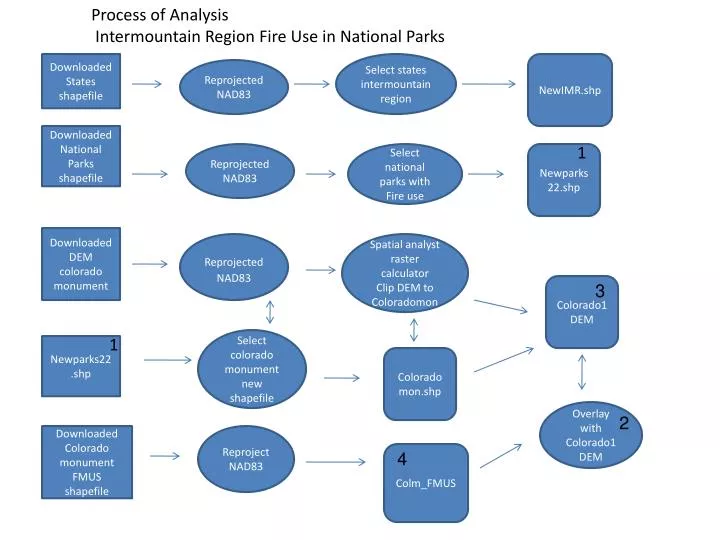
Process of Analysis Intermountain Region Fire Use in National Parks Downloaded States shapefile Select states intermountain region NewIMR.shp Reprojected NAD83 Downloaded National Parks shapefile 1 Reprojected NAD83 Select national parks with Fire use Newparks22.shp Downloaded DEM colorado monument ReprojectedNAD83 Spatial analyst raster calculator Clip DEM to Coloradomon Colorado1 DEM 3 1 Select colorado monument new shapefile Newparks22.shp Coloradomon.shp Overlay with Colorado1 DEM 2 Downloaded Colorado monument FMUS shapefile Reproject NAD83 Colm_FMUS 4
Add Colorado1 DEM, ColmFMUS, coloradomon.shp, Roads 2 3 Create Map Document Map document with park management shapefile and previous. Colomon.mxd Final map document Downloaded roads from national atlas Colomonstrms, in this case fictitious , no streams in this park due to ephemeral nature Clip Streams to ColmFMUS Downloaded Streams from USGS Spatial Analyst function HILLSHADE of Colorado1 DEM Add Coloshade to current map document Colorado1 DEM Coloshade ColmFMUS 4 Query acreage for fire use attributes Calculate fire use areas against non fire use management Final analysis acreage This process was duplicated for all 6 National Parks we have fire use shapefiles for.