Beyond Peeks Creek
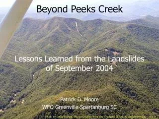
Beyond Peeks Creek. Lessons Learned from the Landslides of September 2004. Patrick D. Moore WFO Greenville-Spartanburg SC. Photo by David Phillips, Macon County News and Shopping Guide, 23 September 2004 edition. By Way Of Introduction…. Did You Know? The WFO GSP Forecast Area has the….

Beyond Peeks Creek
E N D
Presentation Transcript
Beyond Peeks Creek Lessons Learned from the Landslides of September 2004 Patrick D. Moore WFO Greenville-Spartanburg SC Photo by David Phillips, Macon County News and Shopping Guide, 23 September 2004 edition
Did You Know?The WFO GSP Forecast Area has the… • Highest elevation east of the Rockies • Mt. Mitchell…6684 feet • Greatest change in elevation east of the Rockies • 6356 feet • Highest incorporated town east of Rockies • Beech Mountain, NC ~5500 feet
Did You Know?The WFO GSP Forecast Area has the… • Wettest location east of Rocky Mountains • Lake Toxaway, NC… 91.7 inches per year • Driest location south of Ohio River and east of Mississippi River • Downtown Asheville… 37.3 inches per year NC State Climate Office
Did You Know?The WFO GSP Forecast Area has… • Mountain peaks above 4000 feet that average 50-60 inches of snow per year • Comparable to… • Milwaukee, WI (47.3) • Youngstown, OH (55.8) • Hartford, CT (49.0) www.climatesource.com
WFO GSP Forecast Challenges • Cold Air Damming After Bell and Bosart (1988)
WFO GSP Forecast Challenges • Cold Air Damming • Mixed Precipitation Events Larry Lee, NWS
WFO GSP Forecast Challenges • Cold Air Damming • Mixed Precipitation Events • Northwest Flow Snow View looking northeast from Purchase Knob, Haywood County, NC National Park Service
WFO GSP Forecast Challenges • Cold Air Damming • Mixed Precipitation Events • Northwest Flow Snow • Effect of Upstream Convection on Downstream Precipitation
WFO GSP Forecast Challenges • Cold Air Damming • Mixed Precipitation Events • Northwest Flow Snow • Effect of Upstream Convection on Downstream Precipitation • Tropical Cyclone Remnants T.S. Ivan 1620 UTC 16 September 2004 Terra MODIS image from SSEC, Univ. of Wisconsin
September 2004 Hurricanes • Frances landfall near Aucilla R., FL, 6 Sept • Ivan landfall near Gulf Shores, AL, 16 Sept
At about 0200 UTC on 17 Sept 2004, a slope failure at 4420 ft MSL on the northeast side of Fishhawk Mountain (Macon County, NC) initiated a debris flow. Photo courtesy of DigitalGlobe, Inc.
The debris flow moved rapidly down the Peeks Creek basin, traveling 2.25 miles and ending at the Cullasaja River. • 4 fatalities, 9 injuries • 16 homes destroyed • Peak velocity 33 mph • Discharge 70,000 cfs Brian Campbell, NWS, both photos
North Carolina Geological Survey Historical debris flows Landslide forecasts (first one Sept 2004) NOAA - National Weather Service Historical flood events QPF and river forecasts Prior to Peeks Creek… NCGS Swannanoa River flooding in Biltmore Village from remnants of Frances, photo by Steve Dixon, Asheville Citizen-Times
After Peeks Creek… • …both agencies were brought together. • Science sharing…increased situational awareness • Increased public awareness • Better coordination before significant rainfall events Photos by Jonathan Lamb, NWS
Historical Landslide Events in Western NC • ~ 3 years, a storm of high-intensity rainfall occurs over the mountains of the eastern US, posing a high debris flow hazard (Wieczorek et al. 2004) • ~ 9 years, a landslide event occurs in western NC (Gillon et al. 2007) • Major debris flow events happen in western NC every 20 – 30 years (Clark 1987, Witt 2005) Rick Wooten, NCGS
Landslide ThreatIncreased Situational Awareness • Given the proper ingredients… • High antecedent moisture • High intensity rainfall (> 1 in/hr for > 4 hrs) • Slope movements will be… • scattered if rainfall is at least 5 inches in a 24 hour period, particularly on slopes modified by human activity. • widespread if rainfall is greater than 10 inches in a 24 hour period. Source: Rick Wooten, NCGS
Evolution of a Slope Failure • Original slope, thin soil over bedrock Source: Rick Wooten, NCGS
Evolution of a Slope Failure • Original slope, thin soil over bedrock • Cut and fill made for road Source: Rick Wooten, NCGS
Evolution of a Slope Failure • Original slope, thin soil over bedrock • Cut and fill made for road • Cut below road for house Source: Rick Wooten, NCGS
Evolution of a Slope Failure • Original slope, thin soil over bedrock • Cut and fill made for road • Cut below road for house • Another cut and fill above road for house Source: Rick Wooten, NCGS
Evolution of a Slope Failure • Original slope, thin soil over bedrock • Cut and fill made for road • Cut below road for house • Another cut and fill above road for house • Water leaks into fill Source: Rick Wooten, NCGS
Evolution of a Slope Failure • Original slope, thin soil over bedrock • Cut and fill made for road • Cut below road for house • Another cut and fill above road for house • Water leaks into fill • Slope fails Source: Rick Wooten, NCGS
Landslide Threat Increased Situational Awareness • Landslides happen in the cool season as well! • Maggie Valley, NC, 7 January 2009 • 4.85 inches of rain in 24 hours Photo courtesy of NCGS
Landslide ThreatIncreased Public Awareness • NCGS Asheville Regional Office mapping locations of known landslides and potential threat areas • Slope movements/deposits • Stability Index Map • Downslope hazards • All 19 Mountain and Foothill counties will be mapped • Macon, Watauga complete • Buncombe (2009) Both images NCGS
Landslide ThreatIncreased Public Awareness • Maps and data intended as planning tools • Public education • Local government land use planning and permitting • Emergency management Maggie Valley, NC. Photo by Rick Wooten, NCGS
Landslide Advisory ProcessIncreased Coordination • NCGS evaluates antecedent moisture and NWS QPF • Coordination among agencies through NCEM conference call • NCGS issues Landslide Advisory through DENR and NC EOC • NWS GSP includes calls-to-action in Flash Flood Watch/Warning products HPC 24hr Day1 QPF valid 1200 UTC 26-27 Aug 2008 Thank you Dan Petersen!
A Debris Flow Problem… • As far as the NWS is concerned, a debris flow is NOT a flash flood • We have no way of knowing what slopes are in immediate danger of failing, or if one has failed • A debris flow warning would be nearly impossible to issue • The best we can do right now is to mention the threat in a statement or warning • However, this could change Top photo Brian Campbell, NWS, bottom photo Jonathan Lamb, NWS
For More Information… • www.erh.noaa.gov/gsp/localdat/cases/PeeksCreek/PeeksCreek.htm • www.geology.enr.state.nc.us/Landslide_Info/Landslides_main.htm • landslides.usgs.gov • References available upon request Photo by Jonathan Lamb, NWS
Questions? Photo by Jonathan Lamb, NWS