Download
1 / 25
250 likes | 355 Vues
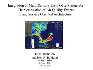
Integration of Multi-Sensory Earth Observations for Characterization of Air Quality Events using Service Oriented Architecture. E. M. Robinson Advisor, R. B. Husar 2010 M.S. Thesis St. Louis, MO, Nov. 3, 2010. Satellite-Integral. Illustrate the use of multi-sensory data.

E N D
Integration of Multi-Sensory Earth Observations for Characterization of Air Quality Events using Service Oriented Architecture E. M. Robinson Advisor, R. B. Husar 2010 M.S. Thesis St. Louis, MO, Nov. 3, 2010
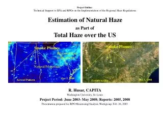
Satellite-Integral Illustrate the use of multi-sensory data Technical Challenge: Characterization • PM characterization requires many sensors, sampling methods and analysis tools • Each sensor/method covers only a fraction of the 7-Dimensional PM data space. • Spatial dimensions (X, Y, Z) • Temporal Dimensions (T) • Particle size (D) • Particle Composition ( C ) • Particle Shape (S) • Most of the 7 Dim PM data space is extrapolated from sparse measured data • Others sensors integrate over time, space, chemistry, size etc. . Satellites, have high spatial resolution but integrate over height H, size D, composition C, particle shape
Kansas Agricultural Smoke, April 12, 2003 Organics 35 ug/m3 max Fire Pixels PM25 Mass, FRM 65 ug/m3 max Ag Fires SeaWiFS, Refl SeaWiFS, AOT Col AOT Blue
Networking Multiplies Value Creation Enclosed Value-Creating Process - ‘Stovepipe’ Data Application 1 User Stovepipe Value =11 Data x 1 Program = 1 “The user cannot find the data; If he can find it, cannot access it; If he can access it, ; he doesn't know how good they are; if he finds them good, he can not merge them with other data” The Users View of IT, NAS 1989
Service Oriented Architecture Actions:Publish – Find – Bind Data Applications Broker The data reuse is possible through the service oriented architecture
Networking Multiplies Value Creation Application Application Stovepipe Data Application Application Application 1 User Stovepipe Value = 11 Data x 1 Program = 1 5 Uses of Data Value = 51 Data x 5 Program = 5
Data Application Data Application Stovepipe Data Application Data Application Data Application Networking Multiplies Value Creation Dataset Description 1 User Stovepipe Value =11 Data x 1 Program = 1 5 Uses of Data Value = 51 Data x 5 Program = 5 Open Network Value = 255 Data x 5 Program = 25 Merging data may creates new, unexpected opportunities Not all data are equally valuable to all programs
Server GetCapabilities Client Std. Interface Std. Interface Capabilities, ‘Profile’ Back End Where? When? What? Which Format? Front End GetData Data Standards needed for Distributed Data Access T1 T2 Convergence Protocols
Data Providers Info System Info Users Public AIRNow AIRNow Model Manager Compliance Scientist DAACs Science ‘Stovepipe’ and Federated Usage Architectures Landscape • Data are accessed from autonomous, distributed providers • DataFed ‘wrappers’ provide uniform geo-time referencing • Tools allow space/time overlay, comparisons and fusion
DataFed: Over 100 Federated Datasets Near Real Time Data Integration Delayed Data Integration Surface Air Quality AIRNOW O3, PM25 ASOS_STI Visibility, 300 sites VIEWS_OL 40+ Aerosol Parameters METAR Surface Visual Range Satellite MODIS_AOT AOT, Idea Project OMI AI, NO2, O3, Refl. TOMS Absorption Indx, Refl. SEAW_US Reflectance, AOT Model Output NAAPS Dust, Smoke, Sulfate, AOT WRF Sulfate Emissions Inventories NEI Point, Area, Mobile EDGAR SO2,NOx,CO2 Fire Data HMS_Fire Fire Pixels MODIS_Fire Fire Pixels
Data Access Data Processing Layer Overlay LAYERS NASA SeaWiFS Satellite RPO VIEWS Chemistry NOAA ATAD Trajectory OGC Map Boundary Web Services: Building Blocks of DataFed ProgrammingAccess, Process, Render Data by Service Chaining Web Service Composition
Exceptional Event Rule:An air quality exceedance that would not have occurred but for the presence of a natural event. Transported Pollution Transported African, Asian Dust; Smoke from Mexican fires & Mining dust, Ag. Emissions Natural Events Nat. Disasters.; High Wind Events; Wild land Fires; Stratospheric Ozone; Prescribed Fires Human Activities Chemical Spills; Industrial Accidents; July 4th; Structural Fires; Terrorist Attack
Evidence for Flagging Exceptional Events • A. Establish a site is in potential violation of the PM2.5 standard. Gather qualitative or quantitative evidence showing that the violation could have been caused by a source that is not reasonably controllable or preventable Viewer: General purpose spatio-temporal data browser and view editor applicable for all DataFed datasets Consoles: Data from diverse sources are displayed to create a rich context for exploration and analysis
May 2007 Georgia FiresAn actual Exceptional Event Analysis for EPA May 5, 2007 May 12, 2007 Observations Used: OMI AI, Airnow PM2.5 DataFed WMS layers overlaid on Google Earth
Evidence for Flagging Exceptional Events • B. Demonstrate a clear causal relationship between the measured exceedance value and the exceptional event. Sulfate Organics CATT: Combined Aerosol Trajectory Tool for the browsing backtrajectories for specified chemical conditions
Evidence for Flagging Exceptional Events • C. The measured high value is in excess of the normal, historical values. - Actual Day 84th Percentile = Difference
Evidence for Flagging Exceptional Events • D. The exceedance occurred but for the contribution of the exceptional source qualify for EE flag.
Social Media Listening for Air Quality RSS Feeds Air Twitter Aggregator Air Twitter Filter ESIPAQWG
Air Twitter – Event Identification August 2009, Los Angeles Fires Normal Weekly Trend
Air Quality EventSpaces EventSpaces are community workspaces on the ESIP wiki that are created to describe the Event Science Data Social Media
MD_Metadata MD_DigitalTransferOption + fileIdentifier [0..1]: CharacterString (O) + contact [1..*] : CI_ResponsibleParty (M) + dateStamp : Date (M) + metadataStandardName [0..1]: CharacterString (O) + metadataStandardVersion [0..1]: CharacterString (O) + metadataLanguage [0..1]: CharacterString (C) + characterSet [0..1]: MD_CharacterSetCode = "utf8“ (C) CI_ResponsibleParty + CI_OnlineResource (O) + individualName [0..1] : CharacterString + organisationName [0..1] : CharacterString + positionName [0..1] : CharacterString + contactInfo [0..1] : CI_Contact + role : CI_RoleCode CI_Citation + title : CharacterString (M) + date [1..*] : CI_Date (M) MD_Distribution EX_GeographicBoundingBox (C) MD_Format +westBoundingLongitude: Decimal +eastBoundingLongitude: Decimal +southBoundingLatiitude: Decimal +northBoundingLatiitude: Decimal + name: CharacterString (O) + version: CharacterString (O) Access Information Contact Information Metadata Description +identificationInfo 1..* MD_DataIdentification + citation : CI_Citation (M) + abstract : CharacterString (M) + extent: EX_Extent (C) + pointOfContact [0..*] : CI_ResponsibleParty (O) + language [1..*] : CharacterString (M) + characterSet: [0..*] : MD_CharacterSetCode = "utf8“ (C) + topicCategory [1..*] : MD_TopicCategoryCode (M) + spatial RepresentationType: [0..*] : MD_SpatialRepresentationTypeCode (O) +spatialResolution [0..*]: MD_Resolution Dataset Description <<Abstract>> EX_GeographicExtent + temporalElement [0..*] (O) + verticalElement [0..*] (O) Spatial/Temporal Extent EX_GeographicDescription (C) ISO 19115 Core M = mandatory O = optional C = mandatory under certain conditions +geographicIdentifier: MD_Identifier