Download
1 / 32
320 likes | 447 Vues
This comprehensive study investigates the interplay between land use, disturbances, and the coupled carbon-climate system. Analyzing data over the past 400 million years, the research emphasizes the critical role of human activity, such as deforestation and fossil fuel emissions, in altering carbon balances. The piece explores how land disturbances affect atmospheric CO2 levels and highlights the challenges of accurately modeling these effects for climate predictions. Mitigating disturbances and making informed land-use decisions are essential to sustaining ecosystem health and climate stability.

E N D
Land use, disturbance, and the coupled carbon-climate system http://earthobservatory.nasa.gov/Features/BlueMarble/ Steve Frolking, University of New Hampshire UNH & Princeton/GFDL NASA EOS IDS research group ‘Advancing our Understanding of the Earth System through Coupled Carbon-Climate Modeling and Observations’; NNX07AH32G 2010 MODIS/VIIRS SCIENCE TEAM MEETING, Washington DC
CO2 and land ice over the past 400 million years IPCC 2007; Ch. 6 AGU Fall 2009 - Bjerknes Lecture RB Alley: The Biggest Control Knob: Carbon Dioxide in Earth's Climate History http://www.agu.org/meetings/fm09/lectures/videos.ph
Global Carbon Cycle – reservoirs and time scales 1016 moles years million years 1018 moles 1016 moles C = 120 Pg C mean residence time of a C atom not necessarily perturbation timescale Walker (1991)
Fate of fossil fuel CO2 over 40,000 yrs Archer and Brovkin (2008)
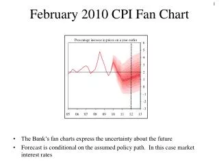
Fate and impact of emitted CO2 over 1000 yrs CO2 ppmv ~20% in air climate model: Bern 2.5CC EMIC • model sensitivity = 3.2°C for 2xCO2 • warming greater over land and at high latitude mean global surface warming ocean thermal expansion not including effect of loss of land ice Solomon et al, PNAS, 2009 ‘irreversible climate change’
MODIS July composite http://earthobservatory.nasa.gov/Features/BlueMarble/ what happens as the ice melts?
Atmospheric CO2 data from Mauna Loa iconic global change environmental data record NOAA ESRL; SIO
Human Perturbation of the Global Carbon Budget fossil fuel emissions Source deforestation CO2 flux (PgC y-1) atmospheric CO2 Sink land ocean Global Carbon Project 2009 Le Quéré et al. 2009, Nature-geoscience
Why is the airborne CO2 fraction increasing? •Emissions are rising faster than the time scales regulating the rate of uptake by sinks. •Sinks are becoming less efficient at elevated CO2 (theirfavorite) – Land: saturation of the CO2 fertilization effect – Ocean: decrease in [carbonate] which buffers CO2 •Land and/or ocean sinks are responding to climate change and variability. • models are missing sink processes that are contributing to the observed changes. (partly related to disturbance and land use) Global Carbon Project 2009 Le Quéré et al. 2009, Nature-geoscience
Land surface disturbance fire, wind, humans, … MODIS-derived global burned areas
Land disturbance (including land use) • abrupt or chronic – (e.g., fire vs. pollution loading) • large or small footprint – (e.g., clear cut vs. selective logging) forest: abrupt and large (>0.1 ha) ~ 500,000 km2/year (~1%) • widespread or restricted – (e.g., fire vs. avalanches) • natural or anthropogenic – (e.g., hurricane vs. logging) • temporary or permanent – (e.g., tornado vs. land conversion) • rapid or slow C flux – (e.g., fuelwood harvest vs. landslide)
impacts of disturbances on atmospheric CO2 • net flux likely smaller than current fossil fuel use… but there are alternatives to fossil fuel use • likely to be small and temporary if > there is recovery - e.g., not land conversion > there is ‘full’ recovery – e.g., not severe land degradation > disturbance rates are relatively constant (interannual var.) • changing disturbance/recovery rates will cause net land-atmosphere C flux, could lead to change in airborne fraction > still likely less than current fossil fuel use > but relevant to • understanding precise [CO2] measurements • making accurate climate predictions • the business of carbon trading
Hurricane Tracks 1851-2005 Return Frequency Tropical Storm Hurricane Tg C y-1 Zeng et al. 2009
Emanuel 2005 Future? power dissipated (damage) increases with SST power dissipation index ensemble runs – random year draw from hurricane history, SST increase damage increase SST 30°S-30°N Biomass Loss (Tg C y-1) ED model simulation 120 storm damage ~35% 80 40 C-loss ~20% Fisk et al 2009 0 2100 1900 1950 2000 2050
The Scale of Land-use • >50% of the land surface has been transformed by direct human action, >25% of forests cleared, >30% in agriculture. • Land-use/Land-cover change affect regional and global carbon balance and weather/climate. • Habitat destruction is the primary cause of species extinctions. • The demand for food, feed, fiber, and fuel are increasing and future land-use decisions (and options) will have consequences for the carbon/climate system.
The carbon impact of land-use, 800-2100 net flux Gt C per year ocean + sediment ~60% 800-1850 land 1850-2000 atmosphere ~40% 2000-2100 Pongratz et al. GBC 2009
IPCC AR4 climate change simulations • included land-use greenhouse gas emissions • no change in land surface properties • no change in land surface energy balance
IPCC AR5 will include land-use – future from IAMs IPCC AR5 Representative Concentration Pathways (RCPs) Moss et al. 2008 “Towards New Scenarios for Analysis of Emissions, Climate Change, Impacts, and Response Strategies”. IPCC, Geneva.
MiniCAM/GCAM Integrated Assessment Model (IAM) Wise et al. Science, 2009
MiniCAM/GCAM Integrated Assessment Model (IAM) Wise et al. Science, 2009 reference scenario: no mitigation, no carbon tax other grassland 1990 2050
MiniCAM/GCAM Integrated Assessment Model (IAM) Wise et al. Science, 2009 reference scenario: no mitigation, no carbon tax RCP4.5: universal C tax RCP4.5: fossil fuel C tax other grassland other grassland other grassland 1990 2050 1990 2050 1990 2050
Importance of continued improvements in agricultural productivity GCAM IAM simulations Thompson et al. in review
IPCC AR5 scheme for land-use LAND-USE HISTORY HYDE 3 Reconstruction: • agriculture • wood harvest • gridded (0.5°) • 1500-2005 LAND-USE HARMONIZATION • consistency • integration • gridding • annual transitions • 1500-2100 Earth System Models • climate • C stocks/fluxes • biophysical effects LAND-USE FUTURE Four IAM RCPs: • population • socioeconomics • energy • land-use • gridded/regional • 2005-2100 Hurtt et al. 2009
Matching cropland distribution in 2005 IMAGE – IAM future for RCP2.6 HYDE 3 – historical reconstruction
Matching cropland distribution in 2005 IMAGE – IAM future for RCP2.6 Cropland fraction by 0.5° grid cell in 2005 0.5° grid cells (n= IMAGE HYDE 3 HYDE 3 – historical reconstruction
Matching wood harvest in 2005 IMAGE regional wood harvest (106 m3 y-1) PRELIMINARY 6 historical national wood harvest (Pg C y-1; Hurtt et al. 2006) 1.0 0 0 2005 1700 2100
IPCC AR5 wood harvest 1700-2100 2005-2100 250 Pg C (includes biofuels) 210 Pg C 180 Pg C PRELIMINARY 160 Pg C 1700-2005: 120 Pg C (Hurtt et al. 2006)
IPCC AR5 Land Use 1700-2100 PRELIMINARY area (107 km2) http://luh.unh.edu
Conclusions 1: Land use in IPCC AR5 LAND-USE HISTORY HYDE 3 Reconstruction: • agriculture • wood harvest • gridded (0.5°) • 1500-2005 LAND-USE HARMONIZATION • consistency • integration • gridding • annual transitions • 1500-2100 Earth System Models • climate • C stocks/fluxes • biophysical effects LAND-USE FUTURE Four IAM RCPs: • population • socioeconomics • energy • land-use • gridded/regional • 2005-2100 Hurtt et al. 2009
Conclusions 2: still a missing feedback LAND-USE HISTORY HYDE 3 Reconstruction: • agriculture • wood harvest • gridded (0.5°) • 1500-2005 LAND-USE HARMONIZATION • consistency • integration • gridding • annual transitions • 1500-2100 Earth System Models • climate • C stocks/fluxes • biophysical effects LAND-USE FUTURE Four IAM RCPs: • population • socioeconomics • energy • land-use • gridded/regional • 2005-2100 Hurtt et al. 2009
Conclusions 3 • most disturbance rates will probably increase in 21st Century • land use extent may, and intensity will, increase in 21st Century • Improving detection & mapping of disturbance and land use Disturbance: impacts/severity, heterogeneity quantify changes in rates recovery – rate and towards what final state Land Use: management – e.g., multiple cropping, irrigation Degradation: impoverishment – erosion, desertification, salinization