Download
1 / 9
90 likes | 194 Vues
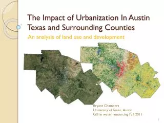
This analysis focuses on the profound effects of urbanization in Austin, Texas, and its surrounding counties. The study evaluates land use changes from 2001 to 2006, highlighting patterns and the extent of change in impervious cover at the subwatershed level. Notably, there was a significant increase in developed impermeable land during this period, with inter-category changes and intra-category changes being analyzed. Maps illustrating development trends from 1992 to 2006 provide insights into how urban centers have evolved, revealing key subwatersheds that experienced notable growth.

E N D
The Impact of Urbanization In Austin Texas and Surrounding Counties An analysis of land use and development Bryant Chambers University of Texas, Austin GIS in water resourcing Fall 2011
Objectives • Examine land use change for: • Patterns of change • How did change occur • Develop %impervious cover at the subwatershed level
01-06 Total Change • 2 digit value YX • Y is old value • X is new value • 4 digit value YYXX • Y is old value • X is new value
How did things change? 2.119409% was inter-category change 0.0440% was intra-category change 92% of the intra-category change was an increase in developed impermeable land 22.55% of inter-category change was an increase in developed impermeable land Inter-category change
How have urban centers developed? 2001 2006 1992 Combined Map of Development 1992, 2001, and 2006
Remaining work • Identify percent impervious land cover in local subwatersheds • Identify subwatersheds with greater than 10% impervious cover • Identify which subwatersheds experienced largest increases over 14 year period
Questions? Taken from xkcd.org by Randall Munroe 11/16/11