Download

1 / 46
480 likes | 901 Vues
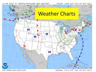
WEATHER CHARTS. Enabling Learning Objective (ELO) A. Action: The student will interpret the information contained in a surface analysis chart. Condition: Given pertinent information about surface analysis charts. Standard: IAW AC 00-45G. SURFACE ANALYSIS CHART.

E N D
Enabling Learning Objective (ELO) A Action:The student will interpret the information contained in a surface analysis chart. Condition:Given pertinent information about surface analysis charts. Standard:IAW AC 00-45G
SURFACE ANALYSIS CHART PURPOSE.... TO PROVIDE THE PILOT WITH A GENERAL PICTURE OF THE WEATHER AT A SPECIFIC TIME
SURFACE ANALYSIS CHART • Chart is issued every 3 hours • Information taken from METAR reports
CONDITIONS DETERMINED FROM CHART • 1. SURFACE WINDS • 2. FRONTAL SYSTEMS • 3. PRESSURE SYSTEMS • 4. SKY COVERAGE • 5. TEMPERATURE AND DEW POINT • PRECIPITATION AND OBSCURATIONS • STATION PRESSURE (corrected for sea level)
15 , 13 315 METAR KATL 151450Z 28025KT 4SM DZFG SCT014 BKN120 OVC300 15/13 A3049 RMK SLP315
OVERCAST (8 octas) CLEAR FEW (1-2 octas) OBSCURED SCATTERED (3-4 octas) SKY COVER MISSING BROKEN (5-7 octas) REF: AC 00-45G
CALM 05 KNOTS 10 KNOTS WIND SPEED 15 KNOTS 20 KNOTS 50 KNOTS 65 KNOTS
15 , 13 TEMPERATURE 315
WEATHER & OBSCURATION , 315 15 13
RAIN HAIL SHOWER DRIZZLE RAIN SHOWER SNOW ICE PELLETS SNOW SHOWER
T/STORM FOG SMOKE FREEZING DRIZZLE FREEZING RAIN HAZE
15 , 13 315 DEWPOINT
315 15 , 13 STATION PRESSURE
1. STATION PRESSURE CORRECTED TO SEA LEVEL 2. SHOWN IN HECTOPASCALS / MILLIBARS 132 1013.2 = 986.6 = 866
L IND TRUE H L L H H
Enabling Learning Objective (ELO) B Action:The student will interpret data contained in a weather depiction chart. Condition:Given pertinent information about weather depiction charts. Standard:IAW AC 00-45G
WEATHER DEPICTION CHART PURPOSE - To portray areas of IFR, VFR and MVFR FREQUENCY - Issued every 3 hours
OVERCAST (8 octas) CLEAR FEW (1-2 octas) OBSCURED SCATTERED (3-4 octas) SKY COVER MISSING OR PARTIAL OBSCURATION BROKEN (5-7 octas) BREAKS IN OVERCAST REF: AC 00-45F
VISIBILITY ONLY SHOWN WHEN 5 SM OR LESS ‚ 4
VISIBILITY NO VISIBILITY SHOWN MEANS VISIBILITY IS GREATER THAN 5 SM
Sky cover symbols shown on the weather depiction chart are the worst sky conditions (summation method) for that station. The altitude below the station will show the ceiling.
CLOUD BASE No altitude will be given if FEW or SCT. If BKN or OVC, height is ceiling. ‚ 4
CLOUD BASE No altitude will be given if FEW or SCT. If BKN or OVC, height is ceiling. ‚ 4 5
W.D. S.A. Using the summation method 020 SCT010 BKN020 OVC030
W.D. S.A. FEW010 FEW020 SCT030
AREAS DEPICTED CEILING AND VISIBILITY GREATER THAN 3000 -- 5 VFR 3000 -- 5 To 1000 -- 3 MVFR CEILING AND /ORVISIBILITY LESS THAN 1000 -- 3 IFR
SHADED AREAS … IFR WITH CIG LESS THAN 1000 FT AND/OR VSBY LESS THAN 3 MI CONTOURED WITHOUT SHADING…MVFR AREAS WITH CIG GREATER THAN OR EQUAL TO 1000 TO LESS THAN OR EQUAL TO 3000 FT AND/OR VSBY GREATER THAN OR EQUAL TO 3 TO LESS THAN OR EQUAL TO 5 MI NO CONTOURS… VFR AREAS WITH CIG GREATER THAN 3000 FT AND VSBY GREATER THAN 5 MI
, , W.D. S.A. 315 15 4 13 120 METAR KATL 151450Z 28025KT4SMDZFG SCT014 BKN120OVC300 15/13 A3049 RMK SLP315
Enabling Learning Objective (ELO) C Action:The student will interpret the information contained on a Radar Summary Chart. Condition:Given pertinent information about radar summary charts. Standard:Technical Information Notice 13-11 NWS (Effective 11 June 3012)
Radar Summary Chart • Shows intensity, coverage, tops, and movement of precipitation • Creates gives a three-dimensional viewpoint of precipitation
Radar Summary Chart • Issued twice per hour (15 and 45 minutes of the hour)
Intensity measured in decibels (dBZ) light green to purple • dBZ • Nondimensional "unit" of radar reflectivity which represents a logarithmic power ratio (in decibels, or dB) with respect to radar reflectivity factor, Z.
Wind barbs show direction the cell is moving FROM “FROM the NE at 15 kts”
Tops of echoes are labeled in hundreds of feet in bold black numbers “Tops at 57,000 ft”
FM 1-230 Referencesfor tomorrow… • TAF App B-11 • Winds Aloft Chart 18-10