Weather Charts
Weather Charts. Current Weather Products. Observations Surface Analysis Charts Constant Pressure Charts Weather Depiction Charts Lifted Index Charts Radar Summary Charts Forecast Charts Short Range Surface Prognostic Chart Low level Significant Weather Prognostic Chart.

Weather Charts
E N D
Presentation Transcript
Current Weather Products • Observations • Surface Analysis Charts • Constant Pressure Charts • Weather Depiction Charts • Lifted Index Charts • Radar Summary Charts • Forecast Charts • Short Range Surface Prognostic Chart • Low level Significant Weather Prognostic Chart
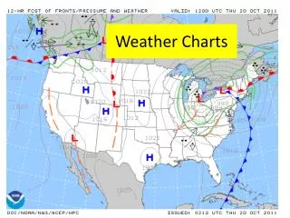
Surface Analysis Chart • Shows the “big picture” – helps plan flights around WX • Depicts • Sea level pressure • Position of highs, lows, ridges and troughs • Position of fronts • Position of boundaries • Overview of winds, temperatures and dew points • Issued every 3 hours • Valid for 6 hours • Available at: http://www.hpc.ncep.noaa.gov/html/sfc2.shtml
Surface Analysis Chart Low Sea Level Pressure –4mb interval lines - Line below # is pressure trend Warm front stationary front Cold front – Pips show direction of movement High - Number adjacent is central pressure Sea Level pressure (first 10 or 9 digits omitted) or ceiling height Tropical wave Wind Data Temp Sky cover – If station symbol is square then automated data was used Dew Point
Constant Pressure Charts • Similar to the surface analysis chart but at different pressure levels (altitudes will vary) • 850 MB chart ≈ 5,000’ • 700 MB chart ≈ 10,000’ • 500 MB chart ≈ 18,000’ • Provides a 3D view of large areas – interpolate between charts • Data gathered through balloons • Shows winds and temps – can identify jet stream / freezing risks for example • Charts available at: http://aviationweather.gov/std_brief/
Constant Pressure Charts X Marks high/low center Issue date/time Wind Level Contour line area of = height in meters (850 MB omits 1 before and 700 omits 2 or 3 before – which ever makes the number closer to 3,000 meters) e.g. 309 = 3309 meters or 10,754’ – Look at gradients - wind speed proportional to gradients (close = high winds). Contours can be interpreted in the same manner as isobars on the surface chart (e.g. high altitude=high pressure area) Some charts also show: isotherms – areas of equal temperature – bold dashed line isotachs – constant wind speed areas – short fine dashed line with __K
Historic (FAA) Constant Pressure Chart Wind Latitude Temp Height / pressure altitude Temp – DP spread Height change / aircraft type Satellite data Balloon / Ground station Data Temp / Isotherm Airplane observation Longitude
Weather Depiction Chart • Broad overview of flying conditions – IFR (<3sm vis;1,000’), MVFR (3 to 5sm vis;1k to 3k ceiling), VFR (>5sm vis; >3,000 ceiling) • Also shows fronts and troughs (except 10 and 23Z) • Prepared 8 X per day
Weather Depiction Chart IFR MVFR Precipitation / Vis obstructions Sky cover AGL cloud height Legend Data
Weather depiction Chart Symbols NB: Symbols are the same as the Surface Analysis Chart
Radar Summary Chart • Aids in preflight planning by identifying general areas and movement of precipitation and/or thunderstorms • Issued hourly • Shows: • Radar echos • Types of precipitation • Movement of cells • Tops of precipitation • Severe Thunderstorm and Tornado Watch areas • DOES NOT SHOW clouds or fog
Radar Summary Chart • Individual cell movement is indicated by an arrow with the speed in knots entered as a number at the top of the arrow head. • Highest echo height in the area is shown above a short line, with the top height displayed. • Severe weather watch areas are outlined by heavy dashed lines, usually in the form of a large rectangular box.
Lifted Index Chart • Provides plot of the lifted index and K index values • Lifted Index • is a measure of atmospheric stability – it is a comparison of predicted temperature change from the surface (2° saturated or 3° unsaturated) less actual temperature change from the surface to 500mb (18,000 msl +/-) • Positive LI – colder so stable air • Negative LI – warmer so less stable • Zero LI – neutral stability • Becomes more stable with decreased dew point, decreasing surface temperature or increasing 500 mb temperature • Severe thunderstorm guide 0 to -2 weak potential; -3 to -5 moderate potential; ≤-6 Strong potentia;
Lifted Index Chart • K Index – used mostly by meteorologists • During warm season a large Ki indicates conditions favorable for thunderstorms • In winter temperature terms completely dominate K index • Ki < 20 – No chance of thunderstorms • Ki 20 to 25 – Isolated thunderstorms • Ki 26 – 30 – Widely scattered thunderstorms • Ki 31 – 35 – Scattered Thunderstorms • Ki > 35 – Numerous thunderstorms
Short Range Surface Prognostic Chart • Surface forecast of pressure systems, fronts and precipitation for two day period – 12, 24, 36 and 48 hours • Uses Surface Analysis chart symbols • Produced 4 x day for 12 and 24 hour periods; twice per day for 36 and 48 hour periods
Short Range Surface Prognostic Chart Shading = >50% coverage; Unshadedprecip indicates 30 to 50% coverage A bold, dashed, grey line is used to separate precipitation within an outlined area with contrasting characteristics Precipitation Trough
Low Level Significant Weather Prognostic Chart • Forecast of aviation weather hazards • Preflight use • 3 versions (High level (FL250-FL630); mid level (FL100-FL450) and low level (SFC-FL240)) • 12 and 24 hour panels; additional charts for 30, 36 and 48 hours • Depicts • VFR, MVFR and IFR areas (top panel) • Freezing levels (top panel) • Turbulence (top panel) • Fronts and pressure systems (lower panel) • Available at: http://aviationweather.gov/products/swl/
NWC AirMet / Sigmet Charts Airmet Zulu - Icing Airmet Sierra - IFR Airmet Tango - Turbulence Freezing levels
Icing SLD (super-cooled large drop - includes freezing drizzle and freezing rain).
Visible Satellite Chart Day Night