Download
1 / 30
300 likes | 554 Vues
The 1 November 2004 tornadic QLCS event over southwest Illinois. Ron W. Przybylinski Science and Operations Officer National Weather Service – St. Louis. NOAA’s National Weather Service. WFO LSX 2008 Winter Weather Workshop. 01 November 2004 QLCS.

E N D
The 1 November 2004 tornadic QLCS event over southwest Illinois Ron W. Przybylinski Science and Operations Officer National Weather Service – St. Louis NOAA’s National Weather Service WFO LSX 2008 Winter Weather Workshop
01 November 2004 QLCS • Convective lines which form and rapidly move across the Mid-Mississippi Valley region during the transitional season can be challenging to the warning forecaster.Some questions we ask: 1) Will the event be only comprised of damaging winds? or 2) Is there a tornado threat? • Will the tornado threat be confined to one part of a bowing segment or are there two areas of concern?
01 November 2004 QLCS During the early part of the afternoon of 01 November 2004 a convective line developed over parts of southeast Missouri and southwest Illinois and produced two weak tornadoes; 1) first having a short path 5 to 7 miles southwest of Sparta and 2) the second damage path from 2 miles southwest of Sparta through the town of Sparta Illinois. A number of large trees were damaged at the Sparta Country Club and damage to a number of building including the steeple of a Church in downtown Sparta Il.
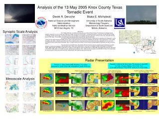
Outline of the case • The first part of presentation will cover the pre and near storm environment on 1 November 2004. • Will be using SPC Mesoscale analysis outputto show the near storm environment conditions. • WSR-88D Doppler radar analysis on the event. • Comparison of this case to another case. • Summary
Large-scale Environment 500 mb 1200 UTC 11/01/2004 850 mb 1200 UTC
Soundings at 1200 UTC 01 Nov 2004 KSGF ML CAPE 1318 J kg-1ML CIN -85 J kg-10 – 6 km shear - 27 m s-10 – 3 km shear - 15 m s-1 KLZK
Bloomfield MO Profiler (west of Cape Girardeau ) Bulk Shear 0 – 6 km 18 m s-10 – 3 km 15 m s-1
SPC Mesoscale Analysis MUCAPE – 1800 UTC SBCAPE – 1800 UTC
SPC Mesoscale Analysis Mean Parcel LCL Height
SPC Mesoscale Analysis 0-6 km Shear25 – 30 m s-1 0-1 km Shear12 – 15 m s-1
SPC Mesoscale analysis 0-3 km Storm Relative Helicity 200 – 250 m2 s-2 0-1 km Storm Relative Helicity - 200 m2 s-2
WSR-88D Radar Imagery at 1934 UTC Base Reflectivity Storm-relative velocity
WSR-88D radar imagery from KLSXat 1944 UTC Reflectivity image showingQuasi-Linear Convective System (QLCS) Storm-relative velocity image(SRM)
Radar Imagery from KLSX at 1949 UTC Nearly Linear convective segment is observed – not much bowing. The TVS was located in the storm’s forward reflectivity gradient region.
Radar Imagery from KLSX at 1954 UTC Mesovortex 1 continues to remain partially embedded within the reflectivity gradient region. Rotational velocity (Vr) values at 0.5° slice was 18 m s-1 (36 kts).
Radar imagery for 1959 UTC Mesovortex 1 approaches Sparta Illinois. MV 1 remains partially embedded within the higher reflectivity. Magnitude of Vr remains at 18 m s-1 (36 kts) – 0.5° slice.
Radar imagery for 2004 UTC MV 1 is now totally embedded with the high reflectivity core region. Vr value at 0.5° elevation slice dropped to 17 m s-1.
Radar imagery at 2014 UTC MV 1 enters its later stages and begins to weaken as it crosses into southwest Washington County. MV 4 is a short-lived mesovortex.
Map of the track of MV 1 Source of damage reports: Storm Data
Rotational Velocity trace MV 1 Magnitudes of Vr values are in m s-1mulitply by 2 to get values in knots.
KLSX Reflectivity / SRM Velocity1952 UTC 11 Feb 1999 Isolated cells merging near the apex of the southern bow echo.
Summary • We reviewed the 1 November 2004 tornadic QLCSas it moved across parts of southwest Illinois. • Pre and near storm environmentlow CAPE – moderate to high shear • Mesovortex rapidly formed along a shear axis • Two weak tornadoes (F0) formed about 12 – 14 min after the initial identification of MV1. • Strongest rotation was confined within the lowest2 km of MV 1. • Tornadoes preceded the deepening and strengthening of MV1
Summary cont • MV 1 core diameter dropped to 2.2 km just prior to tornado touchdown. • Feb 11, 1999 – second case also showed strongest low-level rotation below 2 km. • Tornadoes caused (F1 and F2) damage with thiscase. • Damage survey was conducted during occasional light snow showers and squalls (temps - low 30s).