Download
1 / 23
230 likes | 423 Vues
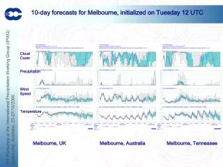
10-day forecasts for Melbourne, initialized on Tuesday 12 UTC. Cloud Cover Precipitation Wind Speed Temperature. Melbourne, UK Melbourne, Australia Melbourne, Tennessee. Impact of Rainfall Observations in ECMWF 4D-Var Data Assimilation System

E N D
10-day forecasts for Melbourne, initialized on Tuesday 12 UTC Cloud Cover Precipitation Wind Speed Temperature Melbourne, UK Melbourne, Australia Melbourne, Tennessee
Impact of Rainfall Observations in ECMWF 4D-Var Data Assimilation System Peter Bauer, Philippe Lopez, Alan Geer, and Deborah Salmond European Centre for Medium-Range Weather Forecasts (ECMWF) Shinfield Park, Reading, Berkshire, RG2 9AX, UK peter.bauer@ecmwf.int
forward inverse xa, A AN state xb, B FG state, error xi State update y(xb.i), F Moist physics-RT model xJ Adjoint: Moist physics-RT model yJ yo, E Satellite data (1D+) 4D-Var Assimilation
Low-level stratus Thin cirrus Typhoon Matsa (04/08/2005 00 UTC) Used SSM/I Clear-sky Channel 3 (22 GHz) Used SSM/I 1D-Var (GMS IR, DMSP F13-15) (Courtesy G. Kelly)
Model too dry Model too moist Typhoon Matsa (04/08/2005 00 UTC) TCWV FG-Departures (GMS IR, DMSP F13-15) (Courtesy G. Kelly)
Typhoon Matsa (04/08/2005 00 UTC) 4D-Var moisture increments with rain assimilation (colors in %), 900 hPa wind increments (white arrows), surface pressure (isolines). MTSAT Infrared image of typhoon MATSA approaching Taiwanese and Chinese coast on August 4, 2005, 00 UTC.
Global operational systems: ECMWF Mean TCWV Analysis/Forecast Difference 08-10/2004 Rain – No Rain Analysis Day 2 (48h) Day 3 (72h) Day 5 (120h) [kg m-2] [kg m-2] [kg m-2] [kg m-2]
Global operational systems: ECMWF Mean MSLP Analysis Difference 08-10/2004 Rain – No Rain Rain Assimilation produces larger MSLP than control Rain Assimilation produces lower MSLP than control [hPa]
Global operational systems: ECMWF Mean 850 hPa Divergent Wind Analysis Difference 08-10/2004 Rain – No Rain Divergence Convergence
Global operational systems: ECMWF Mean Relative Humidity Forecast RMSE Difference 08-10/2004 Rain – No Rain 90% Statistical significance Improvement Deterioration
Case studies: South Atlantic 12Z, 14/08/2005 MSLP TCWV B A Meteosat VIS channel imagery
Case A: Stratiform Precipitation, high TCWV Rain/snow Cloud water/ice Cloud cover temperature dewpoint Analysis First guess 3D model
Case B: Convective Precipitation, low TCWV Rain/snow Cloud water/ice Cloud cover dewpoint temperature Analysis First guess 3D model
Example: 1st cycle ITCZ East Pacific: Rain FG-Departures AN-Differences CY30R2/CY31R1: Moisture Analysis Rain – No Rain Mean August 2004 TCWV difference: Rain FG-Departures AN-Differences unbiased net drying
TCWV increments 1-cycle: 2005080100 1D+4D-Var Assimilation system (operational since June 2005) Direct 4D-Var Assimilation system (experimental) [kg m-2]
RMSE Z1000 N.AMER (21 cases, own ana) RMSE Z200 N.ATL (21 cases, own ana) Global experimental systems: ECMWF Assimilation over Land: NCEP Stage IV rain accumulations • Observations: Combined hourly rain-gauge and NEXRAD radar precipitation accumulation. • ~1200 observations over continental US per 12-hour cycle. • Available in near real-time incl. quality indicators. • Assimilation experiments: • T511L60, CY29R2, 20/05-20/06 2005;1D+4D-Var, 1D-Var uses only moist physics in observation operator. • Add Stage IV observations to operational data set:
noqUS+StageIV – noqUS noqUS – control Global experimental systems: ECMWF 4D-Var Data Denial Experiment control: all observations (incl. SSM/I rain assimilation over oceans); Experiments noqUS: withdraw TEMP-q, RH2m, HIRS, AMSU-B, SSM/I, AIRS, GOES-WV over US; noqUS+StageIV: as noqUS but add Stage IV data. Mean differences of TCWV analyses at 00UTC
Global experimental systems: ECMWF Assimilation over Land: TRMM 2A12 Rain Rates Mean TCWV analysis increments 1-25/07/2006 at 00UTC
Global experimental systems: ECMWF 24-hour Forecast Differences: Rain – No Rain Rain TCWV RR24h Rain - No Rain TCWV RR24h
Summary Analysis system: General:1st global operational 4D-Var system (since June 2005)! Introduces first satellite observations in cloud/rain affected areas. Incremental 4D-Var efficient and well behaved. 1D+4D-Var: Advantage: - additional quality control, - safe first implementation, Disadvantage: - background fields are used twice, - only moisture increments provided to 4D-Var, - loss of vertical information, - only instantaneous measurements are assimilated. Observations: - Radiance measurements provide sensitivity in both clear and cloudy conditions (compared to rain rate observations). - Microwave radiances very accurately measured, stable calibration, continuous availability from operational satellites. - Combined microphysics + microwave radiative transfer operator well behaved and not too non-linear. Errors: - Observation + modelling errors can only be indirectly derived (but realistic). - Background errors require improved specification inside clouds/precipitation. Control variable: - Desirable: Control variable that includes water vapour and condensates.
Future • Employ 1D+4D-Var system with microwave sounder/imager observations over land surfaces. • Fully implement direct 4D-Var radiance assimilation system: • - make use of quality control lessons learned from 1D+4D-Var system. • - allow variable use of different imager/sounder channel combinations as in clear-sky applications. • - extend to infra-red observations from space. • Requires: • - Background error formulation that is more cloud/precipitation specific. • - Developments towards total water control variable. • - Continuous efforts towards improved moist physics parameterizations. • Combined efforts of physics/data assimilation/satellite sections at ECMWF • Programmatic involvement: • - Global Precipitation Measuring (GPM) mission, NASA & JAXA, 2013+. • - Post-EPS programme, Eumetsat, 2020+. • - Earth Explorer programme, ESA, uncertain. • - WMO International Precipitation Working Group (IPWG).
AMSR-E+ AMSR-E+ AMSR-E+ AMSR-E+ Definition of passive microwave imager specs for post-EPS • Eumetsat Polar System (EPS) follow-on, 2020+ • Study on dedicated specifications for clouds and precipitation: channel selection • Channel identification and hydrometeor retrieval accuracy estimation (also with AMSR-E as baseline) Rain Snow ocean land (Channel priorities for land/ocean surfaces, global profile datasets, optimal estimation theory, x-axis: mean entropy reduction)
Publications Andersson, E., P. Bauer, A. Beljaars, F. Chevallier, E. Hólm, M. Janisková, P. Kallberg, G. Kelly, P. Lopez, A. McNally, E. Moreau, A. Simmons and J.-N. Thépaut, 2005: Assimilation and Modelling of the Hydrological Cycle. Bull. Amer. Meteor. Soc., 86, 387-402. Andersson, E., E. Hólm, P. Bauer, A. Beljaars, G.A. Kelly, A.P. McNally, A.J. Simmons, and J.-N. Thépaut, 2006: Analysis and forecast impact of the main humidity observing system. Q. J. Roy. Meteor. Soc., submitted. Bauer, P., J.-F. Mahfouf, S. di Michele, F.S. Marzano, W.S. Olson, 2002: Errors in TMI rainfall estimates over ocean for variational data assimilation. Q. J. Roy. Meteor. Soc., 128, 2129-2144. Bauer, P., E. Moreau, F. Chevallier, and U. O'Keefe, 2006: Multiple-scattering microwave radiative transfer for data assimilation applications. Q. J. Roy. Meteor. Soc., 132, 1259-1281. Bauer, P., P. Lopez, A. Benedetti, D. Salmond, and E. Moreau, 2006: Implementation of 1D+4D-Var assimilation of precipitation affected microwave radiances at ECMWF, Part I: 1D-Var. Q. J. Roy. Meteor. Soc., in press. Bauer, P., P. Lopez, A. Benedetti, D. Salmond, S. Saarinen and M. Bonazzola, 2006: Implementation of 1D+4D-Var assimilation of precipitation affected microwave radiances at ECMWF, Part II: 4D-Var. Q. J. Roy. Meteor. Soc., in press. Benedetti, A., P. Lopez, P. Bauer, and E. Moreau, 2005: Experimental use of TRMM Precipitation Radar observations in 1D+4D-Var assimilation. Q. J. Roy. Meteor. Soc., 131, 2473-2495. Benedetti, A., P. Lopez, E. Moreau, P. Bauer and V. Venugopal. 2005: Verification of TMI-Adjusted Rainfall Analyses of Tropical Cyclones at ECMWF Using TRMM Precipitation Radar. J. Appl. Meteor., 44, 1677-1690. Chevallier, F., P. Bauer, J.-F. Mahfouf, and J.-J. Morcrette, 2002: Variational retrieval of cloud profiles from ATOVS observations., Q. J. Roy. Meteor. Soc., 128, 2511-2525. Chevallier, F. and P. Bauer, 2003: Model rain and clouds over oceans: Comparison with SSM/I observations. Mon. Wea. Rev., 131, 1240-1255. Errico, R., P. Bauer, and J.-F. Mahfouf, 2006: Assimilation of cloud and precipitation data: Current issues and future prospects. J. Atmos. Sci., submitted. Lopez, P., and E. Moreau, 2005: A convection scheme for data assimilation: Description and initial tests. Q. J. Roy. Meteor. Soc., 131, 409--436. Lopez, P., A. Benedetti, P. Bauer, M. Janisková, M. and M. Köhler, 2006: Experimental 2D-Var assimilation of ARM cloud and precipitation observations, Q. J. Roy. Meteor. Soc., 132, 1325-1347. Mahfouf, J.-F., P. Bauer, and V. Marécal, 2003: The comparative impact of the assimilation of SSM/I and TMI rainfall rates in the ECMWF 4D-Var system, Q. J. Roy. Meteor. Soc., 131, 437-458. Marécal V. and J.-F. Mahfouf, 2000: Variational retrieval of temperature and humidity profiles from TRMM precipitation data. Mon. Wea. Rev., 128, 3853-3866. Marécal, V., J.-F. Mahfouf, and P. Bauer, 2002: Comparison of TMI rainfall estimates and their impact on four-dimensional variational rainfall assimilation. Q. J. Roy. Meteor. Soc., 128, 2737-2758. Marécal V. and J.-F. Mahfouf, 2002: Four-dimensional variational assimilation of total column water vapour in rainy areas. Mon. Wea. Rev., 130, 43-58. Marécal V. and J.-F. Mahfouf, 2003: Experiments on 4D-Var assimilation of rainfall data using an incremental formulation. Quart. J. Roy. Meteor. Soc., 129, 3137-3160 Moreau, E., P. Bauer, and F. Chevallier, 2002: Variational retrieval of rain profiles from spaceborne passive microwave radiance observations. J. Geophys. Res., 203, D16, 4521, doi: 10.1029/2002JD003315, ACL11-1-ACL11-18. Moreau, E., P. Lopez, P. Bauer, A. Tompkins, M. Janisková, and F. Chevallier, 2003: Rainfall vs. microwave brightness temperature assimilation: A comparison of 1D-Var results using TMI and SSM/I observations. Q. J. Roy. Meteor. Soc., 130, 827-852. O'Dell, C.W., P. Bauer, and R. Bennartz, 2006: A fast cloud overlap parameterization for microwave radiance assimilation. J. Atmos. Sci., submitted.