Download
1 / 1
10 likes | 99 Vues
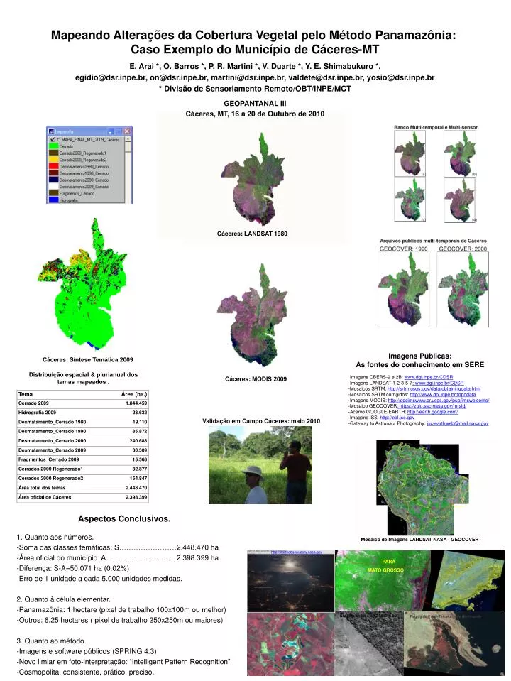
Mapeando Alterações da Cobertura Vegetal pelo Método Panamazônia : Caso Exemplo do Município de Cáceres-MT. Cáceres : LANDSAT 1980. Imagens Públicas : As fontes do conhecimento em SERE. Cáceres : Síntese Temática 2009. Distribuição espacial & plurianual dos temas mapeados.

E N D
Mapeando Alterações da Cobertura Vegetal pelo Método Panamazônia: Caso Exemplo do Município de Cáceres-MT Cáceres: LANDSAT 1980 ImagensPúblicas: As fontes do conhecimentoem SERE Cáceres: SínteseTemática 2009 Distribuição espacial & plurianual dos temas mapeados . -Imagens CBERS-2 e 2B: www.dgi.inpe.br/CDSR -Imagens LANDSAT 1-2-3-5-7: www.dgi.inpe.br/CDSR -Mosaicos SRTM: http://srtm.usgs.gov/data/obtainingdata.html -Mosaicos SRTM corrigidos: http://www.dpi.inpe.br/topodata -Imagens MODIS: http://edcimswww.cr.usgs.gov/pub/imswelcome/ -Mosaico GEOCOVER: https://zulu.ssc.nasa.gov/mrsid/ -Acervo GOOGLE-EARTH: http://earth.google.com/ -Imagens ISS: http://eol.jsc.gov -Gateway to AstronautPhotography: jsc-earthweb@mail.nasa.gov Cáceres: MODIS 2009 E. Arai *, O. Barros *, P. R. Martini *, V. Duarte *, Y. E. Shimabukuro*. egidio@dsr.inpe.br, on@dsr.inpe.br, martini@dsr.inpe.br, valdete@dsr.inpe.br, yosio@dsr.inpe.br * Divisão de Sensoriamento Remoto/OBT/INPE/MCT GEOPANTANAL III Cáceres, MT, 16 a 20 de Outubro de 2010 Validaçãoem Campo Cáceres: maio 2010 AspectosConclusivos. 1. Quantoaosnúmeros. -Soma das classes temáticas: S……………………2.448.470 ha -Áreaoficial do município: A.………………………..2.398.399 ha -Diferença: S-A=50.071 ha (0.02%) -Erro de 1 unidade a cada 5.000 unidadesmedidas. 2. Quanto à célulaelementar. -Panamazônia: 1 hectare (pixel de trabalho 100x100m oumelhor) -Outros: 6.25 hectares ( pixel de trabalho 250x250m oumaiores) 3. Quantoaométodo. -Imagens e software públicos (SPRING 4.3) -Novo limiaremfoto-interpretação: “Intelligent Pattern Recognition” -Cosmopolita, consistente, prático, preciso. Mosaico de Imagens LANDSAT NASA - GEOCOVER http://earthobservatory.nasa.gov PARÁ MATO GROSSO Região de Puno-Titicaca: lagodeclinando. Geoglifo do Acre HRC-CBERS 2B