Salt Water
Salt Water . Study Guide Answers . 1. What causes Waves?. Answer: The wind. 2. What causes tides?. Answer: Tides are mostly caused by the gravitational pull of the earth, moon and sun. 3. How often do tides occur?. Answer: -2 High and 2 Low every 24 hours

Salt Water
E N D
Presentation Transcript
Salt Water Study Guide Answers
1. What causes Waves? Answer: The wind
2. What causes tides? Answer: Tides are mostly caused by the gravitational pull of the earth, moon and sun
3. How often do tides occur? Answer: -2 High and 2 Low every 24 hours -So, every 6 hours it goes from high to low or low to high Possible Tide Chart: 4:00 am-high 10:00 am-low 4:00 pm-high 10:00 pm-low
This is a view from above the North Pole. This is what is happening at the beach!
4. What is Salinity Answer: The amount of salt that is dissolved in water
5. What is the average salinity of the ocean? Answer: 35 parts per 1,000 grams 3.5 parts per hundred grams .35 per 10
6. What is the most abundant salt in the ocean water? Answer: Sodium Chloride NACL
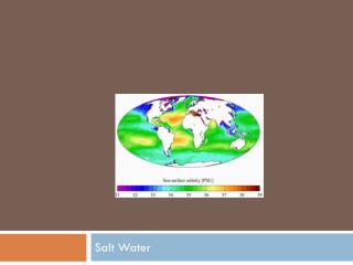
7.Which areas have high Salinty? Low Salinity? Why? Answer: High: Where there’s a lot of evaporation. Evaporation leaves the salt behind when it changes liquid water to gas Low: Mouth of a river. The fresh water meets salt water causing lower salinity.
NOAA map of ocean's salinity. Continents in gray • Salinity varies based on • Temperature and evaporation of water. When water evaporates, it leaves the salt behind making the water saltier (orange). 2. Closeness to a “fresh” water source like a river or icebergs causes low salinity (blue).
8. What happens to water temperature as you descend through the ocean? Answer: Decrease in temperature
9. What happens to pressure as you descend through the ocean? Answer: It increases!!!
10. How does density affect the ocean? Answer: Density=mass ÷ volume More dense=sink Less dense=rise up Salinity = increases density Cold water is denser than warm water
What does this mean?!? Usually….. Deep ocean water= cold and high salinity SINKS Surface water=warm and less salinity RISES UP
11. Describe deep ocean currents • Caused by the change of density (more dense=sink, less dense=rise up) • Temperature and salinity effects the density (colder and more salinity in the deep parts) • Caused from the polar ice caps
12. Describe surface ocean currents • Caused by wind • Paths are deflected due to corealiseffect • Remember Corealis is the path of the currents due to the rotation of the Earth
Surface currents are caused by wind. Surface currents near the equator are warm.
13. What is the Coriolis Effect? the apparent curving of the path of a moving object from an otherwise straight path due to the Earth’s rotation.
14. What affect does the Coriolis Effect have on currents in the Northern and Southern Hemisphere? Southern Hemisphere: Counter clockwise (Opposite of a clock) Northern Hemisphere: Clockwise
15. What is the Gulf Stream and why does it affect England’s weather? Ocean currents can affect climate by warming or cooling the air above the current. Example – England is warmer than it should be based on its latitude because of the Gulf Stream current coming from the southern USA.
16. List three ways we explore the ocean floor. • SCUBA-Self contained breathing apparatus. Makes humans able to breathe underwater • Sonar-uses sound waves to map the ocean floor • Submersibles-small vehicles that are designed for underwater exploration • Satellites-used for temperature, salinity, storm tracker, etc.
Ship using sonar and what it discovered. Sonar – (S0und Navigation and Ranging) Sonar tells us about the shape of the ocean floor by sending sound waves to the ocean floor and measuring how long it takes the energy to return. This tells us the topography of the ocean floor. Do you remember what topography is?
Submersible craft are built to withstand deep ocean pressure. Often they are unmanned and have robotic "arms."
17. What is the difference between the continental shelf and the continental slope? • Continental shelf – relatively flat part of a continental margin that is covered by shallow ocean water • Continental slope – marks the boundary between the crust of the continent and the crust of the ocean floor.
18. What is the difference between the mid-ocean ridge and trench? Where are the located? • Trenches – the greatest depths found along the edges of the ocean floor • Midocean ridge – mountain ranges on the ocean floor.
19. What is a tsunami and where do they occur and why? Tsunami is a large wave that is caused by an underwater earthquake.
20. How do ocean currents, waves, and tides affect the climate of coastal areas? ?