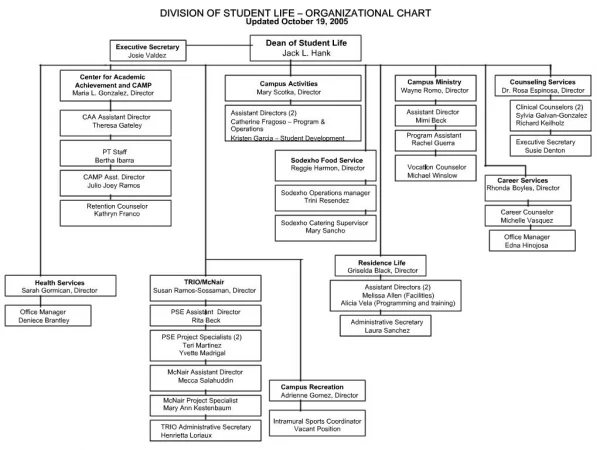
Download
1 / 17
170 likes | 186 Vues
Stay updated with the latest activities and engagements of the EO4SDG Initiative. Learn about recent workshops, forums, and key progress indicators in advancing the Sustainable Development Goals (SDGs).

E N D
Report from the EO4SDG InitiativeExecutive Secretary Dr. Argyro (Argie) Kavvada, NASA/ BAH EO4SDG Executive Secretary Argyro.Kavvada@nasa.gov Secretariat@eo4sdg.org
Timeline of Recent Activities with EO4SDG Engagement 4/9-12 7th IAEG-SDGs Mtg. 4/24-25 UNEP Regional Workshop, Bogota, Colombia 4/ 26-28 9th Global Forum on Urban Resilience and Adaptation 5/2 UN SPB Forum 5/7-12 GEOGLAM RAPP/ SDG/ ARDC Workshop 6/11-12 GEO Symposium 6/17-18 Congress on SDGs - Black Sea Region 6/18-22 UNEP Regional Workshop, Bangkok, 06/27 WGGI Virtual Mtg. 7/9-18 UN HLPF 7/30-8/3 UN-GGIM 8, SDG Training 8/12, 15-17 RCMRD Conference, SDG 11.3.1 training 8/26-31 World Water Week 9/6 IAEG-SDGs Virtual September Mtg. 9/ 17-19 UN/ Austria Symposium, Space for SDGs 9/24-25 73rd UNGA 10/16-18 32ndCEOS Plenary 10/22-24 UN World Data Forum 2018 10/29-11/2 GEO Week 2018 11/5-8 8th IAEG-SDGs Mtg. 11/7-9 UNEP SDG 6.6.1 Consultation Workshop, Lake Como, Italy 11/19-21 UN World Geospatial Congress 12/6-8 5th WGGI Mtg. 12/ 10-14 AGU Fall Meeting 2/18-22 UN Habitat N. Africa/Arab States/W. Asia Workshop 3/5-8 50th Session - UN Statistical Commission 3/11-15 UNEA 4
Timeline of Recent Activities with EO4SDG Engagement 7/9-18 UN HLPF 7/30-8/3 UN-GGIM 8, SDG Training 8/12, 15-17 RCMRD Conference, SDG 11.3.1 training 8/26-31 World Water Week 9/6 IAEG-SDGs Virtual September Mtg. 9/ 17-19 UN/ Austria Symposium, Space for SDGs 9/24-25 73rd UNGA 10/16-18 32ndCEOS Plenary 10/22-24 UN World Data Forum 2018 10/29-11/2 GEO Week 2018 3/5-9 49th Session – UN Statistical Commission 4/9-12 7th IAEG-SDGs Mtg. 4/24-25 UNEP Regional Workshop, Bogota, Colombia 4/ 26-28 9th Urban Resilience & Adaptation Forum 5/2 UN SPB Forum 5/7-12 GEOGLAM RAPP/ SDG/ ARDC Workshop 6/11-12 GEO Symposium 6/17-18 Congress on SDGs - Black Sea Region 6/18-22 UNEP Regional Workshop, Bangkok, 06/27 WGGI Virtual Mtg. 11/5-8 8th IAEG-SDGs Mtg. 11/7-9 UNEP SDG 6.6.1 Consultation Workshop, Lake Como, Italy 11/19-21 UN World Geospatial Congress 12/6-8 5th WGGI Mtg. 12/ 10-14 AGU Fall Meeting 2/18-22 UN Habitat N. Africa/Arab States/W. Asia Workshop 3/5-8 50th Session - UN Statistical Commission 3/11-15 UNEA 4
July 30-31 SDG Training at UN-GGIM 8 Workshop Highlights: • Approximately 35 people from the Americas participated, with the majority from SIDS in the Caribbean. • Focus on water management, land cover, and land degradation as part of the SDGs, including remote sensing techniques; overview of data portals and tools for visualizing and acquiring EO SDG training workshop as part of the UN-GGIM 8 Meeting on July 30-31, 2018 at UN Headquarters, New York. Credit: EO4SDG Guest speaker Mariano Gonsalez of Conservation International provides remote presentation on Use of Trends.Earth tool with SDGs Credit: EO4SDG Director, Geospatial Solutions, Australian Bu- reau of Statistics on use of EO data from a NSO perspective. Credit: EO4SDG UN-GGIM’s Inter-Regional Advisor, Greg Scott on the overarching Strategic Statistical Geospatial Framework. Credit: EO4SDG Presentation material: https://arset.gsfc.nasa.gov/all/workshops/GGIM-SDGs-18
UN High Level Political Forum 2018 Highlights: • Theme: Transformation towards sustainable and resilient societies • Review progress on: Goal 6, water and sanitation; Goal 7, affordable and clean energy; Goal 11, sustainable cities and communities; Goal 12, responsible consumption and production; Goal 15, life on land; and, Goal 17, partnerships for the Goals. • Emphasis on regional solutions (i.e., South-to-South Cooperation) • GEO / CEOS participation in Australia-organized special side-event on the use of EO and SDGs at the UN HQ, followed by two hands-on workshops (Financing and Priority)) at the Permanent Mission of Australia UN Exhibit ‘Space for Sustainable Development’ Credit: EO4SDG Australian Government organized a special side-event around EO uses with SDGs, followed by two hands-on workshops. Credit: EO4SDG Director, Geospatial Solutions, Australian Bureau of Statistics on use of EO data from a NSO perspective. Credit: EO4SDG
Advancement of SDG Indicators 6.6.1 & 6.3.2 to Tier II (April 2018) Done via collaboration with UNEP Outreach & Communications Documentation of country examples, case studies, & smart practices of EO for SDGs EO4SDG Progress Report – August 2018 Release of CEOS SDG Handbook EO4SDG Blog Post RSE Special Issue, AGU Manuscript Website: http://eo4sdg.org • Scaling & Country Examples • 11.3.1, Land use efficiency • Done in collaboration with UN Habitat, DANE/Colombia, other countries • Highlights: > Workshop at RCMRD International Conference • > SDG 11.7.1, Average share of built-up area of • cities that is open space for public use for all Key Progress
Additional (Tier II & III) indicators & UN Custodian Agencies [working toward EO integration] • 2.4.1, UN FAO • 6.3.1, WHO • 9.1.1, World Bank 11.7.1, UN Habitat 15.2.1, UN FAO • 14.1.1, UNEP, UNESCO-IOC … among others Tier II EO integrated in SDG guidance and methodologies UN IAEG-SDGs WGGI WGGI Task Stream on “Application of satellite Earth Observation Data for the SDG indicators”, included in IAEG-SDG WGGI, Work Plan 2018-2019 SDG Methodologies with EO integration documented & approved UNEP, indicator 6.6.1 “… a progressive methodology…which promotes country-derived data collection to be complemented by other globally available datasets such as Earth observations..” UNCCD, Indicator 15.3.1: ““…In the absence of national data, Earth observation represents the next best way to measure land degradation over large areas ….”” UN Habitat, Indicator 11.3.1: “Data for this indicator is available for all cities and countries (UNDESA population data) and satellite images from open sources. The measurement (calculation of size) of urban extent follows classification of satellite imagery”
Collaboration with UN Environment 6.6.1 Change in the extent of water-related ecosystems over time • In 2017-2018: GEO, EO4SDG, NASA, EC/JRC, ESA, among others, contributed to the revised monitoring methodology for 6.6.1 on spatial extent of open waters / vegetated wetlands and WQ of lakes & artificial water bodies. • 2017: UN Environment initiated 2 pilots with EC/JRC and NASA on the use of satellite EO to address sub-indicators of 6.6.1 • April 2018: Upgrade to Tier II • 2018: EO4SDG continued to work with UNEP & countries to extend applied use of EO for water-related ecosystems monitoring. Countries include: Peru, Uruguay, Brazil, Colombia, Panama, Colombia, Senegal, Gabon, Benin, among others • Country consultation workshop convened by UNEPon ”Using EO for monitoring SDG progress in regard to SDG 6 indicator 6.6.1 on water-related ecosystems”, Italy on 7-9 Nov 2018. Participation by: UAE, Uganda, Colombia, Afghanistan, Zambia, Malaysia (NSOs + Water Managers) Technical Brief http://eo4sdg.org
Toward a Satellite-Based Monitoring System for Water Quality Lat =-15.40, Lon = -71.06 • EI Pañe Reservoir, • Arequipa, Peru Time-series corresponds to the marked location (star) 29th June 2017 17th July 2017 13th August 2017 Landsat-8 Sentinel-2A Sentinel-2B 2 km Credit: N. Pahlevan nima.pahlevan@nasa.gov Chlorophyll-a
Toward a Satellite-Based Monitoring System for Water Quality Lat =-15.40, Lon = -71.06 EI Pañe Reservoir, Perú Time-series corresponds to the marked location (star) Feedback from ANA/Perú Credit: N. Pahlevan nima.pahlevan@nasa.gov
Development of tool to assess the ratio of land consumption rate to population growth rate Figure 1. The output from the Trends.Earth tool reporting on Sustainable Development Goal (SDG) 11.3.1: Land consumption in Bogota, Colombia with Sub-urban (orange), Urban (red), Fringe open space (green), Captured open space (dark green) classes calculated using remotely sensed data. Work in Progress • Work with UN Habitat, DANE/ Colombia, other countries, and GEO community on methodology comparison & refinements, tool development. • SDG 11.7.1, access to open shared space in cities Background: • Work to extend use of Earth observation data for land use efficiency monitoring (SDG 11.3.1), building on collaboration with, and progress made by, Colombia/ DANE on 11.3.1 • Promotes user driven assessments -- Trends.Earth provides high-resolution spatial and temporal datasets for measuring land consumption rates in urban areas validated in 10 countries. • Trends.Earth uses remotely sensed imagery to measure urban extent to map change over time and overlays gridded population to asses the land consumption rate. The tool is easy and free to use. Highlight: • Twenty-eight participants attended the training on the use of Trends.Earth during the pre-conference workshop to the Regional Centre for Mapping of Resources for Development (RCMRD) International Conference (RIC) in Nairobi, Kenya in August 2018. PI: Alex Zvoleff, Conservation International
Developing a user friendly digital system for use by the Ugandan Ministry of Water and Environment, to enable national authorities to generate spatial time series statistical data for taking inventory and monitoring national wetland resources Producing a roadmap for scaling to other countries of East Africa. Supporting Organizations – Ministry of Water and Environment, of the Republic of Uganda – DHI GRAS, Denmark – GeoVille, Austria – ITC University of Twente, Netherlands – European Space Agency, Italy – Bureau of Statistics, Uganda Wetlands Monitoring with EO in Uganda
EO4SDG Contribution “The integration of statistics, geospatial information, Earth observations, and other sources of Big Data, combined with new emerging technologies, analytics and processes, are becoming a fundamental requirement for countriesto measure and monitor local to global sustainable development policies and programs” UN-GGIM co-chairs
Future Outlook Country Examples • Country good practice use cases • Emphasis on strong collaboration with the statistical community at national and global levels • Contributions to national reporting requirements on the SDGs; ability to scale to regional or global scale • Capacity building to effectively co-design, and, employ methods, & sustain EO uses for SDGs Scaling • Widespread, sustained utilization of EO for target setting and indicator monitoring & reporting • Case studies w/ testimonials; ongoing outreach; training; capacity building & adoption activities • Broader applicability for EO (at SDG / target level & for SD management strategies) Developing a plan for concretely enabling more Tier advances • In consultation with WGGI; engagement with countries (national use cases); in collaboration with UN custodian agencies • EO4SDG Federated Role within GEO • Engage with GEO Sec and thematic GEO Work Programme elements on SDG targets/ indicators • Develop EO4SDG website into SDG interactive knowledge resource for GEO & extended community
Upcoming: EO4SDG AWARDS PROGRAM • Conduct annual awards for exemplary uses of Earth observations to support SDGs and their respective targets and indicators. • Honor productivity, ingenuity, proficiency, novelty, and exemplary communications of results and experiences in the use of EO to support sustainable development. • Provide GEO Member countries, GEO Participating organizations, GEO Work Programme elements, UN Custodian Agencies, among others, with an opportunity to promote their outstanding efforts and achievements, and learn from good practice use cases. http://eo4sdg.org @EO4SDG
How is your activity or organization supporting / can support the implementation, monitoring, and evaluation of the SDGs? • Based on your experiences, what are key challenges in harmonizing EO with other data sources, and mainstreaming EO uses in support of SDG processes? • How can the EO4SDG Initiative engage with your initiative / project and vice versa? How can EO4SDG and GEO support you in engaging with the SDGs? Items to consider
PANEL 1 Eleanor Stokes, Unites States AndiswaMilsa, South Africa Paloma Merodio, Mexico EvangelosGerasopoulos, Greece Trevor Dhu, Australia MODERATOR : ARGYRO KAVVADA, NASA/BAH,EO4SDG