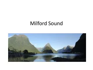
Milford Sound
Milford Sound. Location of Milford Sound. Milford Sound is a fjord (drowned glacial valley) in the Southland region in the southwest of the South Island

Milford Sound
E N D
Presentation Transcript
Location of Milford Sound • Milford Sound is a fjord (drowned glacial valley) in the Southland region in the southwest of the South Island • Milford Sound lies within Fiordland National Park; a sensitive landscape of unspoiled wilderness commanding World Heritage Area status. • Milford Sound is a remote isolated location to the west of Queenstown but divided from these more populous areas of Southland by the Southern Alps dividing range. • Latitude • Longitude
Activity 1 • On your blank NZ map show ….. The region of Southland The Southern Alps Queenstown Milford Sound Label the latitude line and longitude line running through Milford Sound
Activity 2 • Produce a climate graph for Milford Sound using both the average high and average low in degrees celsius and the monthly rainfall in mm’s. • Write generalisations to describe the climate in Milford Sound that discuss • Temperature range • Total annual rainfall • Seasonal fluctuations
Climatic characteristics • Heavy rainfall (6761mm p.a.) • Orographic rainfall due to effect of mountains • Wettest inhabited spot in NZ • Cold winter temperatures even though at sea level and moderated by the sea. • Mild / Cool summer temperatures • Regarded as a subalpine climate (just below freezing and below the snowline
Characteristics of Fiordland Indented coastline Fiords (drowned glacial valleys) Broad U-shaped glacial valleys Steep rugged mountain ranges (part of the Southern Alps) Alpine regions (above snowline) Sheer rock faces rising to 1200m Clad in native rainforests in subalpine areas.
How was this environment formed? And how did it develop these characteristics
What processes have produced the Fiordland landscape Five key physical processes have all played a role • Mountain building • Glaciation (see separate powerpoint) • Physical weathering: particularly freeze – thaw weathering in subalpine regions • Climate change • Sea Level fluctuations
Milford Sound A gem of a place… • Milford Sound is often described using superlatives like………. • A National treasure • The Jewel in Fiordland’s tourism crown • The Goose that lays the golden egg. • Which of these superlatives suggests Milford Sound is of… • i) environmental importance • ii) economic importance • iii) regional significance • iv) national significance
Visitor numbers to Milford Sound • Only 20% of NZ’s 2.5 million visitors made it to Milford Sound • 550,000 visitors per year to Milford Sound • 54% of tourists to South Island travel the Milford Road • 60% of visitors travel by coach • 50 coaches and hundreds of private coaches daily • 90% of visitors are day trippers • Projected growth to 750,000 visitors (by 2012?)
Access by air • Numbers of tourists arrive via small planes or helicopters at Milford Sound airport, or use them to overfly the Sound • a concession system limits the number of flights in the Fiordland area and the number of operators to 2004-2005 levels. • In 2004 Milford Sound Airport had approximately 16,000 aircraft movements, most associated with flights to and from Queenstown • 25 aircraft operated here during peak times of the day in 2004.
Difficult Access by sea • Entry to the sound was considered treacherous by Captain Cook • Exposed rugged coastline • Access by sea is limited due to the vast distance from other safe ports on the west coast. • Cruise ship accessible.
Access overland • SH 94 Milford Road is the only access road and is over a difficult yet very scenic mountain road. • The third most dangerous section of State Highway in NZ with injury crash rates 65% higher than the rest of NZ’s network • Avalanche prone in winterand carrying snow chains is mandatory during snow conditions. • Road requires Avalanche control programme • Road lacks passing lanes • Road has a number of ‘One lane bridges’ • Homer tunnel is one way during summer peak periods as it is too narrow for coaches to pass.
Journey by coach using present route to Milford Sound • Departure from Queenstown • Stopover in TeAnau • 304km one way journey by road • Journey time 5 hours one way • Peak demand in Milford Sound between 11a.m – 3p.m • Nightmare trip for parents with young children
Possible Alternative Solutions To the issue of difficult access to Milford Sound
Milford Dart Tunnel Proposal • A10.2 km tunnel through the mountain range with portals at either end. • A 1 kilometre extension to the Routeburn Road to link up to the tunnel portal • A 50metre road from the tunnel exit to the Hollyford road • at least 200,000 passengers per year needed to be commercially viable. • cost around NZ$170 million.
Advantages • Improved connectivity will cut travel distances from 304 km one-way to only 125 km. • travel time reduced from 5.5 hours to 2 hours • Spread of peak demand across the day • Would avoid having to cap visitor numbers • Congestion on Milford Road reduced by spreading peak demand • Benefits for boat operators • Tourists overcome reluctance from distance resistance potentially increasing visitor numbers • Visitor experience improved
Criticisms • the location of both entrances are in national parks, Fiordland National Park in the west and Mount Aspiring Park in the east. • Department of Conservations's general policy forbids the construction of new roads in National Parks. • The disposal of up to 250,000 cubic metres of spoil from the tunnel excavation is also considered problematic • Why carve up more national parks when there is already access?
Criticisms • Queenstown maintaining dominance of tourist market • New tourism will bypass TeAnau • Glenorchy may receive no direct benefit. • It will lead to unsupportable traffic demands on the aging Homer Tunnel. • Private ownership - Controlled by developers and current operators and not able to be used by all. • Birdlife habitats disturbed by road.
Fiordland Link Experience • combine a number of innovative transport options into one trip that includes • A 20km trip in a 25-m catamarans(240 capacity) across Lake Wakatipu to Mt Nicholas station • Followed by a 45km trip in an all-terrain coach on balloon tyres to the Kiwi Burn swing bridge terminal • Followed by a 41km 35 minute monorail and mountain bike track through the beech forest of the Snowdon Forest Conservation Area connecting to TeAnau Downs • joining up with a bus park and ride facility on the existing road to Milford Sound
Fiordland Link Experience proposal • Cost $132 million • 220 000 two way passengers needed for viability
Advantages • the proposal does not touch upon any National Parks • cuts the travelling time to the Sound by about one hour each way • the construction of the monorail and operation process is considered to be very ecologically sustainable • balloon tyres on the all terrain coach reduce impact on the road.
Criticisms • Still relies on coach service on SH 94 to Milford Sound through Homer tunnel. Can this infrastructure cope with increased demand • Time savings are less significant compared with Milford Dart tunnel proposal. • Peak demand is spread but not sufficiently • TeAnau is bypassed and service providers in TeAnau lose business • Potentially vulnerable to weather.
Major tramping tracks Milford Track Routeburn track Rees Dart Track Greenstone/Caples circuit