Download
1 / 12
120 likes | 279 Vues
SAR related activities at Christian Michelsen Research. Kjell Røang. SARA (Search And Rescue Application). Decision support tool for the Joint Rescue Coordination Centres in Norway Operative since 2000

E N D
SAR related activitiesat Christian Michelsen Research Kjell Røang
SARA (Search And Rescue Application) • Decision support tool for the Joint Rescue Coordination Centres in Norway • Operative since 2000 • Primary function is to aggregate and present all relevant information about real and potential emergency incidents, including location-based information on electronic maps • First SW to present results from LeeWay simulations
What is web mapping (WMS) • Standard for transferring map images over Internet • Standardized by Open Gis Consortium (OGC) • First version 1.0.0, 2000-04-19 • Current version 1.3, 2005-08-02 (also ISO/DIS 19128) • Uses HTTP Get and parameters as ”query string” • Transfers the map as image • e.g. As PNG, JPEG, GIF, SVG • Three different requests: • GetCapabilities (What is available) • GetMap (Map image) • GetFeatureInfo (Info about a position on the map) • Standard handling of coordinate systems (CRS) • Handles also time and elevation
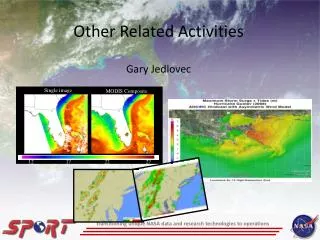
MetOc server • Developed for the Norwegian Defence Research Establishment in collaboration with Met.no • WMS server supports grid data (GRIB), particle simulation results (oil drift, ship drift), observations (scatterometer, altimeter) • Plot time series profiles and cross-sections • Exports and imports GRIB data to and from other servers • Supplies applications with XML data services (profiles, time series, cross section)
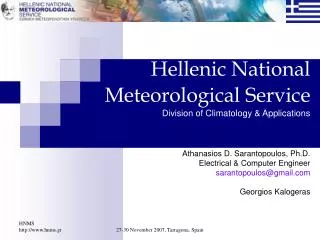
AIS server • Handles multiple AIS sources • Web browser as client (multiple browser support) • Shows traffic info as a map or a table • User defined filters (Norwegian pilots, tankers north of 62) • Multiple custom defined background maps • Support WMS foreground maps • Exports data directly to other applications • Integrated database for historic data • “Smart links” to other web applications