Download
1 / 56
600 likes | 771 Vues
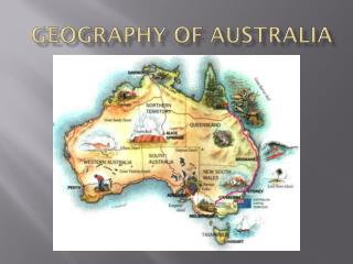
RECORD FLOODING IN AUSTRALIA:. DECEMBER 10 – JANUARY ?, 2011. Walter Hays, Global Alliance for Disaster Reduction, University of North Carolina, USA. GREAT QUEENSLAND FLOOD INUNDATES 22 TOWNS, DISPLACES 200,000, KILLS 20 +, AND CAUSES LOSSES OF OVER $5 BILLION IN AUSTRALIA .

E N D
RECORD FLOODING IN AUSTRALIA: DECEMBER 10 – JANUARY ?, 2011 Walter Hays, Global Alliance for Disaster Reduction, University of North Carolina, USA
GREAT QUEENSLAND FLOOD INUNDATES 22 TOWNS, DISPLACES 200,000, KILLS 20 +, AND CAUSES LOSSES OF OVER $5 BILLION IN AUSTRALIA
RECORD FLOODING IN AUSTRALIA:NEW SOUTH WALESROCKHAMPTONTOOWOOMBABRISBANE DECEMBER 10 – JANUARY ?, 2011
QUEENSLAND: WIDESPREAD IMPACTS • Socioeconomic impacts for 200 thousand people included: industrial slow-down, evacuations, aplague of snakes and crocodiles, health care problems, missing persons, deaths, and losses of 5+ Billion.
WORST FLOODING IN A DECADE REACHES CITY AFTER CITY Floodwaters drained slowly towards the country's northeast coast, filling bulging rivers and inundating at least 22 towns and cities in the cattle and fruit and vegetable farming region.
THE FIRST PHASE OF RECORD FLOODING BEGAN IN DECEMBER DECEMBER 10, 2010
EVACUEES IMPACTED • The time evacuees spent in evacuation centers was extended because the nature and extent of flooding grew worse—not better—over time.
THE SECOND PHASE OF FLOODING HAPPENED IN JANUARY AN AREA OF FLOODING THE SIZE OF FRANCE AND GERMANY (OR, TEXAS AND NEW MEXICO) COMBINED WAS CREATED IN QUEENSLAND
ROCKHAMPTON HIT HARD • Rockhampton, a town of 77,000 people 370 miles north of Brisbane, lies close to the coast, on the Fitzroy, one of Australia's largest river systems.
ROCKHAMPTON HIT HARD • All main routes to the south, north and west of the city were cut off by the rising water, rail lines and the airport runways were submerged, and floodwaters stretched for several miles in each direction.
W ILDLIFE AFFECTED • The local wildlife was caught off-guard by the flooding; bewildered and hungry kangaroos moved to high ground, and cattle were left lost and confused by the excessive water that inundated everything.
COAL MINING INFRASTRUCTURE AFFECTED • Australia's coal industry may face months of disruption because key rail and road links were washed away during the flooding, and repairs of some infrastructure may take more than a year to complete.
THE THIRD PHASE OF FLOODING WAS TRIGGERED BY A FLASH FLOOD JANUARY 11, 2011
FLASH FLOOD IN TOOWOOMBA • The flash flood, which brought a one kilometer wide wall of water into Toowoomba, was triggered by a freak storm — with up to 150 millimeters (6 inches) of rain in half an hour.
IMPACTS • Cars were transformed into “boats” and became scrap metal as they collided with infrastructure; giant metal industrial bins were tossed about as if made of paper; and houses were torn off foundations.
THE FOURTH PHASE OF FLOODING BEGINS IN BRISBANE JANUARY 11 AND FOLLOWING
BRISBANE • The city is protected by a large dam built upstream after floods devastated the downtown in 1974, but the reservoir was full, so officials had no choice but to release water, which caused flooding before the “FLOOD”.
BRISBANE • MORE than 50 suburbs were flooded as the Brisbane River rose to 4.5 m or more above flood stage, with some areas being completely inundated.