Data Sharing
Data Sharing. We all need data There are a huge number of different types of data Needs: Right theme Right Area of Interest (AOI) Right precision and accuracy Compatible format. Challenges. Performance: Local will always be faster GIS datasets can be huge Projection on the fly is slow

Data Sharing
E N D
Presentation Transcript
Data Sharing • We all need data • There are a huge number of different types of data • Needs: • Right theme • Right Area of Interest (AOI) • Right precision and accuracy • Compatible format
Challenges • Performance: • Local will always be faster • GIS datasets can be huge • Projection on the fly is slow • Formats: • New ones are typically too complex • Documentation • Typically the data is available with little documentation • Little or none on accuracy and precision
US Datasets • National Hydrology Dataset (NHD) • National Elevation Dataset (NED) • Digital Raster Graphics (DRGs) • Digital Line Graphics (DLGs) • Digital Ortho-Quarter Quads (DOQQs) • NOAAs new electronic charts? • NationalAtlas.gov
Digital Orthophoto Quads • DOQs or DOQQs • aerial photographs • camera orientation, terrain info. • raster images at 1m resolution • 6m positional accuracy at scale of 1:12000
Vector Data Formats • Point-Specific Formats • Tab-delimited Text • Comma separated values • General Vector Formats • Shapefiles: Really popular • Coverages: Going away? • SDTS: Future uncertain at best? • Scalable Vector Graphics: Not geo-referenced • KML: Widely used, becoming a GIS standard
Raster Formats • Tagged Image File Formats: TIFF • ASCII Grid: Widely used • Imagine: IMG • Ersi Grid: Being replaced by IMG? • JPG: Georeferenced with world file and prj • BIL, BIP, BSQ: and other “binary” formats • All have a “header” file (HDR)
Hierarchical Data Formats • Hold the promise of a single “self-describing” data file • So far the promise has not been met • NetCDF converters now in ArcGIS • Examples: • Hierarchical Data Format: HDF • Network Common Data Form: netCDF
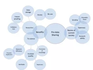
Promise of the “Cloud” • What is the cloud? • Lots of servers on the Internet providing “services” • Promise: • Universal access to data • High-performance • High-quality • Reality: • Lots of problems with compatibility • Typically slow • Questionable to undocumented quality
The Cloud • Esri’s Backgrounds • Great if you use the background’s spatial reference and have strong Internet connection • Problems: • Cut-off labels • Projecting on the fly • Slow Internet connection
Shared Storage Successes • Shared network drive • Can be on a workstation • Define the folder organization! • Make sure it is backed up • DropBox for Teams • Maintains local copies • Trying it out with OSU/DOE research team
Types of GIS Data Websites • Map-based • Can be hard to use • Processing data takes time and lots of complexity • See NationalMap, EarthExplorer • Right click to “save target as” • See NationalAtlas.gov
Metadata • ISO 19115:2003 • Geographic information - metadata • The Federal Geographic Data Committee (FGDC) • Content Standard for Geospatial Metadata • Being superseded by North American Profile (NAP) of ISO 19115:2003 • ISO/TS 19139:2007 • XML Implementation of ISO 19115
ArcGIS • Maintains their own metadata format • Import/Export to and from other formats • ArcToolbox -> Conversion Tools -> Metadata
Jim’s Recommendation • Use and contribute to a “Directory of GIS Web Resources” • See ibis.colostate.edu • When publishing data: • Add at least the required metadata (including accuracy and precision) • Publish on simple web page with links to zipped data in common file formats