Download
1 / 48
490 likes | 970 Vues
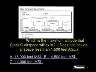
#4530. Which is the maximum altitude that Class G airspace will exist? ( Does not include airspace less than 1,500 feet AGL.). A- 18,000 feet MSL. B- 14,500 feet MSL. C- 14,000 feet MSL. Sorry that is Incorrect. Go Back and Try Again. That’s Right!!! Next Question.

E N D
#4530. Which is the maximum altitude that Class G airspace will exist? ( Does not include airspace less than 1,500 feet AGL.) A- 18,000 feet MSL.B- 14,500 feet MSL. C- 14,000 feet MSL.
Sorry that is Incorrect. Go Back and Try Again.
That’s Right!!! Next Question
#4531. What is generally the maximum altitude for Class B airspace? A- 4,000 feet MSL.B- 10,000 feet MSL. C- 14,500 feet MSL.
Sorry that is Incorrect. Go Back and Try Again.
That’s Right!!! Next Question
#4528. What is the floor of Class E airspace when designated in conjunction with an airport which has an approved IAP? A- 500 feet AGL.B- 700 feet AGL. C- 1,200 feet AGL.
Sorry that is Incorrect. Go Back and Try Again.
That’s Right!!! Next Question
#4476. What are the vertical limits of a transition area that is designed in conjunction with an airport having a prescribed instrument approach procedure? A- Surface to 700 feet AGL. B- 1,200 feet AGL to the base of the overlying controlled airspace. C- 700 feet AGL or more to the base of the overlying controlled airspace.
Sorry that is Incorrect. Go Back and Try Again.
That’s Right!!! Next Question
#4538. When should pilots state their position on the airport when calling the tower for takeoff? A- When visibility is less than 1 mile. B- When parallel runways are in use. C- When departing from a runway intersection.
Sorry that is Incorrect. Go Back and Try Again.
That’s Right!!! Next Question
#4443. What is the significance of an ATC clearance which reads “..CRUISE SIX THOUSAND..”? A- The pilot must maintain 6,000 until reaching the IAF serving the destination airport, then execute the published approach procedure. B- It authorizes a pilot to conduct flight at any altitude from minimum IFR altitude up to and including 6,000. C- The pilot is authorized to conduct flight at any altitude from minimum IFR altitude up to and including 6,000, but each change in altitude must be reported to ATC.
Sorry that is Incorrect. Go Back and Try Again.
That’s Right!!! Next Question
#4646. When en route on V448 from YKM VORTAC to BTG VORTAC, what minimum navigation equipment is required to identify ANGOO intersection? Fig 47 A- One VOR receiver. B- One VOR receiver and DME. C- Two VOR receivers.
Sorry that is Incorrect. Go Back and Try Again.
That’s Right!!! Next Question
#4496. What is indicated by the localizer course symbol at Jefferson County Airport.?Fig. 87 A- A published LDF localizer course. B- A published SDF localizer course. C- A published ILS localizer course, which has an additional navigation function
Sorry that is Incorrect. Go Back and Try Again.
That’s Right!!! Next Question
#4541. In the case of operations over an area designated as a mountainous area where no other minimum altitude is prescribed, no person may operate an aircraft under IFR below an altitude of A- 500 feet above the highest obstacle. B- 1,000 feet above the highest. C- 2,000 feet above the highest obstacle.
Sorry that is Incorrect. Go Back and Try Again.
That’s Right!!! Next Question
#4545. ATC may assign the MOCA when certain special conditions exist, and when within A- 22 NM of a VOR. B- 25 NM of a VOR. C- 30 NM of a VOR.
Sorry that is Incorrect. Go Back and Try Again.
That’s Right!!! Next Question
#4432. The MEA ( Minimum En Route Altitude) assures acceptable navigational signal coverage and A- DME response. B- radar coverage. C- meets obstacle clearance requirements.
Sorry that is Incorrect. Go Back and Try Again.
That’s Right!!! Next Question
#4370. What is the minimum crossing altitude over the BOZEMAN VORTAC for a flight southeast bound on V86? A- 8,500 feet MSL. B- 9,300 feet MSL. C- 9,700 feet MSL.
Sorry that is Incorrect. Go Back and Try Again.
That’s Right!!! Next Question
#4435. Reception of signals from an off-airway radio facility may be inadequate to identify the fix at the designated MEA. In this case, which altitude is designated for the fix? A- MRA. B- MCA. C- MOCA.
Sorry that is Incorrect. Go Back and Try Again.
That’s Right!!! Next Question
#4400. For operations off established airways at 17,000 feet MSL in the contiguous United States (H) Class VORTAC facilities used to define a direct route of flight should be no farther apart than (Hint - see legend 27) A- 75 NM. B- 100 NM. C- 200 NM.
Sorry that is Incorrect. Go Back and Try Again.
That’s Right!!! Next Question
#4366. What is the maximum altitude that you may conduct IFR flight on V-86 between BOZEMAN and BILLINGS VORTACS? Fig 78 A- 14,500 feet MSL. B- 17,000 feet MSL. C- FL 180.
Sorry that is Incorrect. Go Back and Try Again.
That’s Right!!! Next Question
#4078. Where are the compulsory reporting points, if any, on a direct flight not flown on radials or courses of established airways or routes? A- Fixes selected to define the route. B- There are no compulsory reporting points unless advised by ATC C- At the COP (changeover point).
Sorry that is Incorrect. Go Back and Try Again.
That’s Right!!! Move to the next section!!!