Stream Development and Longitudinal Stream Profiles
Stream Development and Longitudinal Stream Profiles. OBJECTIVE. Look at factors that affect stream development Determine how streams vary by region and difference in factors Ultimately be able to compare stream profiles and determine anomalous segments in profile. OUTLINE .
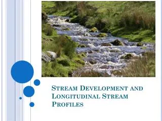

Stream Development and Longitudinal Stream Profiles
E N D
Presentation Transcript
OBJECTIVE • Look at factors that affect stream development • Determine how streams vary by region and difference in factors • Ultimately be able to compare stream profiles and determine anomalous segments in profile
OUTLINE • Longitudinal profiles and what controls stream development • Profiles by region • Methods of obtaining stream profiles • Comparing stream profiles
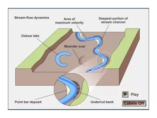
Longitudinal stream profiles • Shows distance vs. elevation of a stream
LONGITUDINAL STREAM PROFILES • Changes on tectonic conditions, climate, or geology cause changes in profile (Cherkauer, 1972). • The main factors that affect its slope are discharge, drainage area, and size of material in the stream bed (Hack, 1957). • Typical profile is concave-up
Susquehanna river • Convex profile • Little uplift • Changes in base level and geology play a more important role than uplift. • Carlston (1969) found 8 streams draining to Atlantic to be convex Ydtalk.com
Profiles in Maryland and Virginia • Shorter streams that help show variation in geology • Schist & sandstone slopes decrease more gradually compared to shale or less resistant units (Hack, 1957)
Texas profiles • Most profiles in TX have a long and concave profile • Some exceptions are nearly linear (slightly concave)- Rio Jemez and Matthole River. • Constant incision rate • Not very tectonically active Tinkler, K.J., 1998
Profile segments • Not all profiles follow one pattern • Streams can be made up of segments based on differences in slope and shape
Arizona Streams-segmented • Steep upstream (concave) • Due to greater rate of change of particle size and drainage area, and higher width to depth ratio of stream • Straight line downstream • Ephemeral streams- exists only after ppt (Cherkauer, 1972)
Glacial Profiles • Wide and low gradient floors. • Profiles characterized by steps shortly after tributary joins main glacier (MacGragor et al, 2000)
Making Stream Profiles • Plot of distance on x-axis vs. elevation above sea level on y-axis • Can infer from topographic maps (Hack, 1957) or DEMs (Snyder et al, 2000) • Survey in the field • Once full profile is acquired, it can be broken up into many segments based on shape
Stream-Gradient Index • Relates the slope of a stream to its length (Hack, 1973) • Allows you to compare different streams • Can determine small knickzones/irregularities • SL= stream-gradient index • ∆H= Change in elevation • L= length of the Stream • ∆L- Length of the specific reach of stream
Stream Gradient Hack, 1957
Stream Gradient • Hack (1957) developed this formula based on profiles in humid regions on the East Coast • Still useful because easy to calculate
Conclusion • Changes on tectonic conditions, climate, or geology cause changes in profile • Different regions show different profiles • A single stream can have many segments • Stream-gradient index is a useful calculation to compare profiles
REFERENCES CITED • Anderson, J.K., Wondzell, S.M., Gooseff, M.N., Haggerty, R., 2005, Patterns in stream longitudinal profiles and implications for hyporheic exchange flow at the H.J. Andrews Experimental Forest, Oregon, USA: Hydrological Processes, v. 19, p. 2931-2949. • Carlston, C.W., 1969, Longitudinal slope characteristics of rivers of the midcontinent and the Atlantic east gulf slopes: International Association of Scientific Hydrology Bulletin, v. 14, no. 4, p. 21-31. • Cherkauer, D.S., 1972, Longitudinal profiles of ephemeral streams in southeastern Arizona: GSA Bulletin, v. 83, p. 353-366. • Goldrick, G., Bishop, P., 2007, Regional analysis of bedrock stream long profiles: evaluation of Hack’s SL form, and formulation and assessment of an alternative (the DS form): Earth Surface Processes and Landforms, v. 32, p. 649-671, doi 10.1002/esp.1413. • Hack, J.T., 1957, Studies of Longitudinal Stream Profiles in Virginia and Maryland: U.S. Geological Survey Professional Paper 294-B, p. 42-97. • Hack, J.T., 1973, Stream-profile analysis and stream-gradient index: Journal Research U.S. Geological Survey, v. 1, no. 4, p. 421-429. • Larue, J.P., 2011, Longitudinal Profiles and Knickzones: the Example of the Rivers of the Cher in the Northern French Massif Central: The Geologists’ Association, v. 122, p. 125-142. • MacGregor K.R., Anderson, R.S., Anderson, S.P., Waddington, E.D., 2000, Numerical simulations of glacial-valley longitudinal profile evolution, v. 28, no. 11, p. 1031-1034. • Pazzaglia, F.J., Gardner, T.W., Merrits, D.J., 1998, Bedrock Fluvial Incision and Longitudinal Profile Development Over Geologic Time Scales Determined by Fluvial Terraces: Rivers Over Rock: Fluvial Processes in Bedrock Channels, p. 207-235. • Rosgen, D.L., 1994, A classification of natural rivers: Catena, v. 22, p. 169-199. • Snyder, N.P., Whipple, K.X., Tucker, G.E., Merritts, D.J., 2000, Landscape response to tectonic forcing: Digital elevation model analysis of stream profiles in the Mendocino triple junction region, northern California: GSA Bulletin, v. 112, no. 8, p. 1250-1263. • Woodside, J., Peterson, E. W., and Dogwiler, T., in review, Longitudinal profile and sediment mobility as geomorphic indicators within a fluviokarst stream system: Journal of Cave and Karst Studies. • Zimmerman, A.E., Church, M., Hassan, M.A., 2008, Identification of Steps and Pools from Stream Longitudinal Profile Data: Geomorphology, v. 102, p. 395-405.