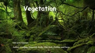
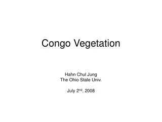
Congo Vegetation
This resource provides a comprehensive analysis of various vegetation types in the Democratic Republic of the Congo (DRC), including flooded forests, semi-deciduous forests, and savannas. It incorporates diverse data sources, including satellite imagery and vegetation maps from the University of Maryland and other references dating back to 1958. The focus is on understanding land cover characteristics and monitoring seasonal forest ecosystems. Key resources detail the phyto-geography and vegetation classifications used for ecological assessment and land management in Central Africa.

Congo Vegetation
E N D
Presentation Transcript
Congo Vegetation Hahn Chul Jung The Ohio State Univ. July 2nd, 2008
http://www.geog.umd.edu/carpe/gisthemes.html Vegetation Maps Edaphic forest (D.R. Congo) Reference: Devred, R., 1958, La vegetation du Congo Belge et du Ruanda-Urundi, Bulletin de la Societe Royale Botanique de Belgique, (65), 409-468. (scale – 1:5,000,000) ********* Flooded forest (Congo) Equatorial, semi-deciduous, and littoral forest Floating prairie Savanna Reference: B. Descoings, 1969, "Phytogeography of Congo", Office de la Recherche Scientifique et Technique Outre-Mer, Bondy, France. (scale - 1:2,000,000)
http://www.geog.umd.edu/carpe/gisthemes.html Vegetation Map from AVHRR, 1982 -1987(from U.Maryland) Reference: N. Laporte, C. Justice, M. Heinicke, B. Lawrence, 1997, "The Use of Time-Series Satellite Data for Characterization and Monitoring of the Seasonal Forests and Savannas of Central Africa"Executive Summary, Biodiversity Support Program, Washington, DC, September1997. Pixel resolution 6.5 km
http://www.geog.umd.edu/carpe/gisthemes.html Vegetation Map from AVHRR, 1990’s(from U.Maryland) Reference: N. Laporte and M. Heinicke,C. Justice , S. Goetz, 1997, "A New Land Cover Map of Central Africa Derived from Multiresolution, Multitemporal AVHRR Data", IJRS Pixel resolution 1or 7 km
http://edc2.usgs.gov/glcc/fao/forest_cover_image.php Global Forest Cover (GFC)from USGS Closed forest 1 km / AVHRR dataset Open or fragmented forest Other wooded land Other land cover water
http://edc2.usgs.gov/glcc/fao/forest_cover_image.php Africa Land Cover Characteristics Data Base from USGS • Derived Data Sets (1 km / AVHRR dataset) • Africa Seasonal Land Cover Regions Legend (197 legends) • I reduce them to 7 classes to compare other data set. (SLCR) • 2. Global Ecosystems Legend (96 legends) • 3. IGBP Land Cover Legend (17 legends) • 4. USGS Land Use/Land Cover System Legend (24 legends) • 5. Simple Biosphere Model Legend (20 legends) • 6. Simple Biosphere 2 Model Legend (11 legends) • 7. Biosphere-Atmosphere Transfer Scheme Legend (20 legends) • 8. Vegetation Lifeforms Legend (8 legends)
1 2 3 1 (Field mapping) 2 (SLCR) 3 (GFC) Flooded forest Equatorial, semi-deciduous, and littoral forest Floating prairie Closed forest Open or fragmented forest Other wooded land Other land cover water
1 2 3 1 (Field mapping) 2 (SLCR) 3 (GFC) Edaphic forest (D.R. Congo) ********* Flooded forest (Congo) Floating prairie Closed forest Open or fragmented forest Other wooded land Other land cover water
TOPEX cycle 168 pass 165 TOPEX cycle 173 pass 165