Download
1 / 21
210 likes | 332 Vues
Geographic Information Systems (GIS) are vital for the collection, management, analysis, and dissemination of spatial data. They integrate software, hardware, data models, and trained personnel to create detailed representations of geographic phenomena. GIS involves two primary data models: raster and vector, which help in understanding spatial relationships and conducting analyses like topology creation, overlay functions, and statistical evaluations. As GIS technology evolves, its applications in various fields will expand, offering innovative solutions to geographical challenges.

E N D
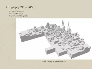
Geography 241 – GIS I Dr. Patrick McHaffie Associate Professor Department of Geography Cook County, % population < 5
What is a GIS? Geographic Information System - collection, organization, maintenance, analysis, and output of spatially-referenced information. Two important components - What, and Where
We usually understand GIS to be computer-facilitated system • GIS is NOT only software/hardware • Also includes: • Trained personnel • Supporting Institution • Protocols for use
GIS Hardware Typical of most computer systems, with a little more storage, a few added tools for input/output. Coordinate input devices are the primary “specialized” hardware. Digitizing Tablets GPS receivers.
INPUT ANALYSIS STORAGE OUTPUT Digitizing Graphic editing, error correction: sliver removal, data sanitation, Tabular data entry and editing Data reduction Text conversion Graphic analysis capabilities - topology creation, reclassification, buffer, overlay, network, neighborhood functions, coordinate management Database manager Statistical functions Map composition Color palette generation Symbol generation, editing Graphic overlay Screen query Geographic query GIS Software
What is in it for me? Take a sheet of paper, put your name and major at the top. Then, In a five minute free write, answer the question: How can you imagine you might be using GIS and other Geotechnology in 5 years?
phenomena that exist computer representation An abstraction, relevant phenomena and properties
REPRESENTATION AND DATA STRUCTURES Coordinates and Attributes
Many objects for a theme, with properties recorded for each object
REPRESENTATION AND DATA STRUCTURES • Most common data models define thematic layers • Typically, layers, one layer for each distinct view of a theme
Vector Topology Topology – geometric properties that to not change with shape: Adjacency, connectivity, containment
Rasters – Discrete or Continuous Features discrete continuous
Raster – The Mixed Pixel Problem Landcover map – Two classes, land or water Cell A is straightforward What category to assign For B, C, or D?
Summary • GIS are systems for the creation, maintenance, analysis, and conveyance of spatial data • We represent abstractions of our world into spatial and attribute components using data models and data structures • Two major data models – raster and vector