Enhanced Visibility Analysis for Protected Areas Using Satellite & Ground-Based Data
This research introduces a novel method to analyze sources of visibility impairment in Class I areas by integrating satellite and ground-based measurements. By leveraging various datasets, including IMPROVE surface monitors, NPS webcam images, EPA PM2.5 data, and satellite imagery, a comprehensive understanding of pollutant sources impacting protected sites is achieved. The study employs tools like the HYSPLIT model and NASA MODIS images to enhance visibility assessments in environmentally sensitive regions. This innovative approach offers valuable insights into the dynamics of visibility degradation and aids in identifying potential mitigation strategies for preserving air quality in pristine locations.

Enhanced Visibility Analysis for Protected Areas Using Satellite & Ground-Based Data
E N D
Presentation Transcript
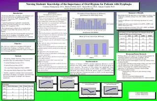
Visibility Analysis of Class I Areas Using Multiple Satellite Products & In-Situ Ground Based Measurements Nikisa Jordan(1), Jill Engel-Cox(2,1), Raymond Hoff(1), Kevin McCann(1), Kamonayi Mubenga(1) (1)CREST, Joint Center for Earth Systems Technology, University of Maryland Baltimore County, 1000 Hilltop Circle, Baltimore, MD, 21250 email: njordan1@umbc.edu (2)Battelle Memorial Institute, 2101 Wilson Boulevard, Suite 800, Arlington, VA 22201email: engelcoxj@battelle.org
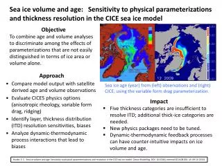
Objective • Current methods & tools for studying visibility impairment involve • Ground-based back trajectory receptor models • Surface point measurements • This research offers a new approach of studying the sources of visibility degradation to Class I areas • Satellites can provide a better understanding of the pollutant source and, potentially, its concentration in protected sites. • Suites of satellite and ground-based measurements were used to provide an enhanced understanding of pollutant sources to protected areas
Data Used • In-Situ • IMPROVE surface monitors • National Park Service (NPS) Webcam images • EPA PM2.5 data was used in addition to IMPROVE aerosol data • NOAA Air Resources Laboratory (ARL) (HYbrid Single-Particle Lagrangian Integrated Trajectory) HYSPLIT model • Spaceborne • NASA MODerate Resolution Imaging Spectroradiometer (MODIS) true color images • NASA MODIS Aerosol Optical Depth (AOD) • NOAA GOES Aerosol & Smoke Product (GASP) AOD • NOAA Hazard Mapping System (HMS) Fire and Smoke Product
* Modified from Source: EPAhttp://www.epa.gov/air/visibility/monitor.html