Download
1 / 29
310 likes | 486 Vues
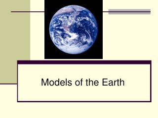
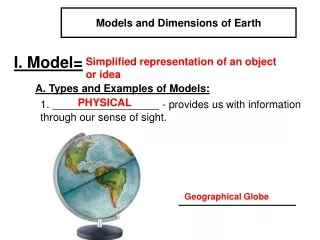
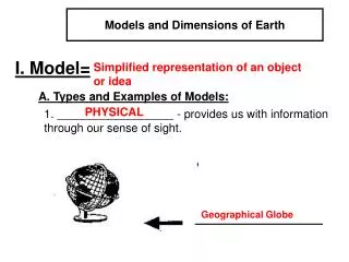
Models and Dimensions of Earth. I. Model=. Simplified representation of an object or idea. A. Types and Examples of Models:. PHYSICAL. 1. __________________ - provides us with information through our sense of sight. Geographical Globe. Models and Dimensions of Earth. Mechanical.

E N D
Models and Dimensions of Earth I. Model= Simplified representation of an object or idea A. Types and Examples of Models: PHYSICAL 1. __________________ - provides us with information through our sense of sight. Geographical Globe
Models and Dimensions of Earth Mechanical 2. __________________ - a physical model with moving parts so that it can perform the functions or movements as the original model. Model Electric trains
Models and Dimensions of Earth Mathematical model 3. __________________ - mathematical relationships expressed by symbols, formulas, and equations. Equations
Models and Dimensions of Earth Graphic model 4. __________________ - a graph to provide a “picture” of a relationship of symbols, formulas, and equations. Temperature vs. Month Graph
Models and Dimensions of Earth Mental 5. __________________ - models that can only exist in someone’s mind. Water is made of 2 Hydrogen and 1 Oxygen molecules
II. Shape of Earth Oblate spheroid Flattened sphere • ________________ - _________________ • ______________________ • ______________________ • Diagram of an __________________________ Flattened at the poles Bulging at the equator Oblate spheroid NOT TO SCALE Polar diameter Equatorial Diameter
greater 4. Earth’s equatorial circumference is ______________ than its polar circumference. a. Equatorial circumference - ___________________ b. Polar circumference - ______________________ 24,900 miles 24,860 miles
B. Causes of Earth’s Shape 1. _____________________ an inward pulling force. This force pulls equally in all directions and causes earth to be _______________________. Gravity an oblate sphere . Key___________ = force of gravity
Centrifugal Force 2. ________________- an apparent outward force caused by the spinning (or rotating) of earth on its axis. This force causes earth to _________________. a. The faster the rotational speed, the ____________ the centrifugal force. b. (1) How long does it take each location to make one complete rotation? X___________ Y___________ Rotate faster 24 hours 24 hours X Y
(2) Which location, X or Y, travels a greater distance to make one complete rotation? ____________ (3) At which location, X or Y, is the rotational speed greater? _____________ (4) At which location, X or Y, is centrifugal force greater? _____________ c. Therefore, the greater centrifugal force causes earth to bulge at the __________________________. Location X Location X Location X Equator X Y
C. Evidence of Earth’s Shape • Photographs from space reveal that Earth is • _______________________ • 2. Observations of ships on the horizon Round The gradual “appearance” or “disappearance” of a ship over the horizon is evidence that earth’s surface is ____________________. Curved
3. Observations of an Eclipse of the Moon (as viewed from Earth) a. As viewed from space: As the moon orbits Earth, and travels from position 1 to position 2, it passes through ______________________________________. Earth’s shadow
b. As viewed from Earth: c. Earth’s shadow on the moon (full moon) during a lunar eclipse provides evidence that Earth is __________________________. Curved
4. Measurement of Gravity a. b. The shorter the distance between two objects, the greater the gravitational force. Therefore a person or object that is closer to the center of Earth (the center of gravity) would weight more than when the person or object is farther from the center of gravity.
c. (1) If Earth is an “oblate spheroid”, where on the surface of Earth would a person be closer to the center of Earth? _________________________ (2) Where on the surface of Earth would a person weigh the most? _________________________ d. Under what circumstance would a person weigh the same everywhere on Earth? At the poles At the poles If Earth was a perfect sphere.
5. Observation of North Star, Polaris • The altitude of Polaris changes as an observer moves north or south (in the Northern Hemisphere); • this is because Earth is _____________, and its surface is _____________________. • (Altitude is the height, measured in degrees that a heavenly body is above the horizon of the observer). a sphere curved
90 ° North 90 ° 60 ° North 60 ° 30 ° North 30 ° 0 ° 0 °
c. Canada 60 ° N Alt. of Polaris 60 ° North Pole 90 ° N Altitude of Polaris = 90 ° 60 90 Equator 0° Alt. of Polaris 0° Atlanta 30 ° N Alt. of Polaris 30 ° 0 30
d. Summary: Altitude of Polaris = Latitude As latitude increases altitude of Polaris increases. NORTH STAR- POLARIS e. Locating the North Star
IV. Latitude and Longitude • Latitude- • Parallels- • Equator- • North/South Pole- The angular distance North or South of the equator. Lines that measure latitude that never touch. Reference line for 0° latitude. Midway between both poles. Highest possible latitude, 90° North, 90° South 90°North 60° North Arctic Circle 30°North Tropic of Cancer 0° Equator 30°South Tropic of Capricorn 60° South Antarctic Circle 90°South
IV. Latitude and Longitude • B. Longitude- • Meridians- • Prime Meridian- • International Date Line- The angular distance East or West of the Prime Meridian. Lines of longitude that connect from pole to pole. Reference line for longitude 0°, that goes through Greenwich England. Largest possible longitude, 180°
120 ° West 30 ° North 45 ° South 75 ° East 0 ° 135 ° West 135 ° East 45 ° North 70 ° South 165 ° West
45 ° South 180° 45 ° North 75 ° West 70 ° North 0 ° 15 ° South 15 ° East 20 ° South 45 ° West
North America South America Europe Asia Africa Australia Antarctica
Atlantic Pacific Indian Antarctic Arctic
6 AM • D. Earth’s Time Zones • As Earth rotates on its axis, half of earth is facing the sun and is experiencing daylight; the other half is in darkness and is experiencing night. • 2. When the sun is directly over a certain meridian, it is 12 noon at any location at or near that meridian. 12 Noon 12 AM 6 PM Right Hand Rule
Rate of Earth’s rotation ? 3. Think: Earth is a sphere/degrees in a circle = Time/ Hours to make one complete rotation = 4. a. Number of time zones on Earth = b. Approximate width of each time zone = 360° = 15°/hr 24 hours 24 time zones 15°
5. a. If it is Wednesday, and you cross the International Date Line going west, it would then be _________________ b. It is Tuesday, and you cross the International Date Line while traveling east, it would then be _________________ International Date line- Day change Tuesday Wednesday
6. • How many time zones are there in the continental U.S.? • _________________ • b. Is it earlier or later in California than New York? • _________________ • c. If it is 8:00 EST, what time is it in PST? • _________________ • d. It is 6:00 MST, what time is it in EST? • ____________________ 4 time zones Earlier 5:00 8:00