Download
1 / 26
260 likes | 417 Vues
Physical Description Southwest Asia/Eastern Mediterranean/North Africa Unit 6. SSWG3 The student will describe the interaction of physical and human systems that have shaped contemporary North Africa/Southwest Asia.

E N D
Physical DescriptionSouthwest Asia/Eastern Mediterranean/North AfricaUnit 6 SSWG3 The student will describe the interaction of physical and human systems that have shaped contemporary North Africa/Southwest Asia. a. Describe the location of major physical features and their impact on North Africa/Southwest Asia. b. Describe the major climates of North Africa/Southwest Asia and how they have affected the development of North Africa/Southwest Asia. c. Analyze the impact natural resources, especially oil, have on North Africa/Southwest Asia. d. Analyze the impact of water supplies on the growth of population centers. f. Explain why this region contains areas on two different continents.
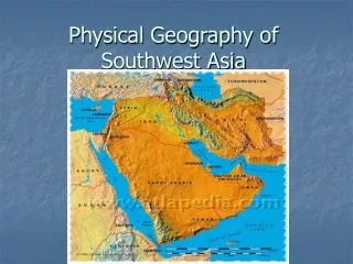
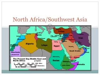
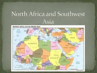
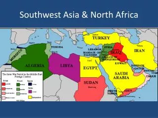
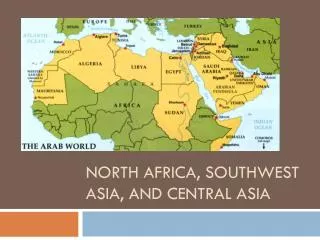
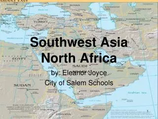
3 Regions of the Middle East 1. Persian Gulf and Interior • Mesopotamia • Includes Saudi Arabia, Bahrain, Kuwait, Oman, Qatar, the United Arab Emirates, Yemen, Iraq, Iran, and Afghanistan 2. Eastern Mediterranean • Israel, Jordan, Lebanon, Syria, Turkey, and Cyprus 3. North Africa • Egypt, Algeria, Libya, Morocco, Tunisia
Persian Gulf & Interior/Landforms • Arabian Peninsula makes up majority of region • Tectonic forces shaped landforms • Collision of plates created rugged mountains, upland plateaus & valleys • has earthquake activity • Mountains provide water to valleys below • Hindu Kush mountain range is largest in region • Part of Himalayas (world’s largest mountains) • Peaks over 24,000 feet
Hindu Kush mountain fighting • http://www.youtube.com/watch?v=CoUq9x8ZBD4
Bodies of Water/Persian Gulf & the Interior • Tigris & the Euphrates (1) • Mesopotamia—land between the rivers • Important water source for early civilizations and modern-day Iraq
Bodies of water continued • Persian Gulf (2) • Forms border of 3 major countries --Iraq, Iran, Saudi Arabia • Serves as extension of Arabian Sea & the Indian Ocean • Sometimes called Arabian Gulf • Contains many oil & natural gas reserves
Climate/Persian Gulf & the Interior • Most of area contains arid/dry climate • Many deserts • Saudi Arabia has hottest temperatures in the world • Up to 114 degrees in the summer • Wealthy people head to mountains to avoid heat • Iran and Saudi Arabia have mountain resorts • Water ski in mountains
Natural Resources/Persian Gulf & the Interior • Oil and water are most important resources • World’s largest oil fields • Surface water rare • Farmers irrigate fields with canals • Oasis: area where spring bubbles to the surface • Turned into wells • Desalinization: process of turning salt water into fresh water • Very expensive and takes lots of power • Saudi Arabia is the largest producer
5 Hazards to Development in Persian Gulf and Interior 1. Earthquakes caused by earth’s plates moving apart 2. Some areas have salty soil where no plants can grow 3. Most wild animals have been hunted and endangered • Hyenas, leopards, lions, tigers, wild camels, donkeys 4. Area lacks important natural resources except oil 5. Religious conflict and war
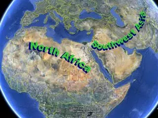
Eastern Mediterranean/Landforms • Region lies on 2 continents • Turkey in Asia and Europe • Includes Pontic and Taurus Mountains • Pontic Mountains: North • Taurus Mountains: South • Area has many plateaus, hills, and valleys
Negev Desert/Landforms • Israel’s driest region • National Water Carrier • Carries water from Lake Kinneret to Israel’s Negev Desert/other parts of Israel • uses drip irrigation to grow crops in the desert • Drip irrigation: Process by which pipes placed near plant roots drip only as much water as the plants need to grow
Bodies of Water/Eastern Mediterranean • Jordan River (1) • Flows south to the Dead Sea • Dead Sea (2) • Lowest point on any continent • Lies between Israel & Jordan • Over 1,300 feet below sea level • So salty no fish or animals can survive • Swimmers will not sink
Bodies of water continued Dead Sea Continued • Israelis built processing plants to extract minerals • Extract 2 minerals: Potash & Magnesium • Potash: mineral used to make fertilizers, explosives, table salt, glass, soap • Magnesium: light metal important in aircrafts
Dead Sea video clip • http://www.youtube.com/watch?v=OEArUTI7Moo • http://www.youtube.com/watch?v=aTcyACmiaho
Climate/Eastern Mediterranean • Dry and Middle-Latitude climates Climate depends on: 1. Distance to Mediterranean Sea 2. Elevation 3. Rainfall • Perfect for forests, but many cut down
Natural Resources/Eastern Mediterranean • Turkey has coal, copper, and iron • Area has some oil and natural gas deposits • Potash, Magnesium, and spa minerals from Dead Sea
3 Hazards to Development/Eastern Mediterranean 1. Turkey lies on many tectonic faults • Lots of earthquakes 2. Deforestation caused by centuries of farming, herding, shipbuilding, and firewood 3. Religious conflict and war between Israel and surrounding countries
Landforms/North Africa • Sahara Desert • World’s largest desert • Size of United States • Extends across all of North Africa • Natural barrier between North Africa and rest of continent • Highest temperature ever recorded on earth • 136 degrees
Bodies of Water/North Africa • Nile River • Flows northward for 4, 187 miles • Empties into the Mediterranean Sea • Nile Delta • Delta: land formed by soil in the water that is dropped as the river slows & enters the sea • fertile • The fellaheen or Egyptian farmers grow crops in the delta w/out the aid of modern machinery • About 99% of Egypt’s population lives in the Nile Delta • 5,000 people per square mile
Nile River/North Africa continued • Flooding of the Nile --long tradition • Refreshes soil in the fields of the delta • Nile River is no longer flooded ---Why? • 1970---completion of the Aswan High Dam • Nile waters dammed in a reservoir to provide water for agriculture year round • Reservoir: artificial lake • PROBLEM: • Farmers forced to chemically fertilize crops b/c no flooding resulted in loss of fertilization
Climates/North Africa • Mediterranean climate found along N. Africa’s coast • Warm, dry summers/mild rainy winters • Arid climate covers most of N. Africa • Hot dry wind called a harmattan sweeps across N. Africa • Violent sandstorms caused by winds can block sunlight for days
Natural Resources/North Africa • Oil and natural gas are most valuable • Oil found in every country • Libya has largest oil reserves • Morocco is the largest exporter of sardines • 350,000 tons of sardines a year
Hazards to Development/North Africa 1. Desertification: transformation of fertile land into a desert usually caused by overuse • Oil refining pollution 2. Polluted water from fertilizer • Killing most of fish