Requirement for atmospheric corrections
110 likes | 233 Vues
This document details the requirements for atmospheric corrections on TOA reflectance, focusing on Rayleigh, ozone, and water vapor corrected reflectance through linear stretch images. It emphasizes the need for robust validation methods using various validation systems, including SP and MOD08, highlighting the importance of a comprehensive web-based GIS framework. The text discusses the manipulation of high-level data, the need for user-friendly interfaces, and the significance of integrating satellite data with ground observations to enhance accuracy and network scalability in environmental monitoring.

Requirement for atmospheric corrections
E N D
Presentation Transcript
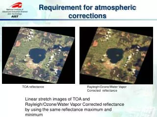
Requirement for atmospheric corrections TOA reflectance Rayleigh/Ozone/Water Vapor Corrected reflectance Linear stretch images of TOA and Rayleigh/Ozone/Water Vapor Corrected reflectance by using the same reflectance maximum and minimum
Surface reflectance and Top of the atmosphere Image from: http://www.profc.udec.cl/~gabriel/tutoriales/rsnote/cp9/cp9-2.htm
Mar. Apr. May Jun. Jul. Aug. Sep. Oct. Nov. Dec. Jan. Feb. TKY TGF MSE RHN PEN Equipments ADFC SP HSSR http://www.pheno-eye.org
Previous System Framework PMS PSS Web Page Input Query DB • Time consuming and need high level user experience. • Lack of Robustness and scalable • Not convenience for sharing among communities PEN Observation System PEN DB & Backup SP ADFC Manipulating (filter, average etc.) HSSR Data Gathering Query value at pixel Validation and Plotting Site B Site D Site C MODIS MOD08 Daily image Correction On developing
OGC System Framework WMS,WMS-T SOS PSS 52NorthSOS Mapserver PEN Observation System SP ADFC Overpass time scene MODIS MOD08 Daily image HSSR GetObservation [During MODIS overpass time from start to end] JSON GetFeatureInfo [MODIS value from start to end] JSON GetObservation ADFC WPS R rpy2 simplejson Etc.. • PyWPS • Validation process • Least Square Fitting process Execute [station,start,end,product] JSON Client
Conclusion • Comprehensive web-based GIS system framework enabled • Based on various open standards of OGC specifications • Using FOSS • Mapserver, 52North SOS, PyWPS • OpenLayers, jQuery, • Assimilation of sensor observation data and satellite image • Wider area, More accuracy, Reasonable cost • Validation of aerosol properties from Satellite estimation with ground based sites • Improve the following product which relied on satellite image “surface reflectance”
Future Development • Increase atmospheric observation network • Skynet • Improving performance • Distributing ground site data source • More than two million records for two station and four years • WMS-T full supported with Mapserver • MOD03 overpass time to MOD08 Global dataset • Possible to error 5 minutes observation • Satellite image product validation • GLEON (Global Lake Ecological Observatory Network) • Lake monitoring : SST, Chl. A : MODIS Ocean product • CO Flux monitoring : Asiaflux / Japanflux • Water Column Correction • CREON (Coral Reef Environmental Observatory Network) • Validation with higher satellite image resolution • ASTER, FOMARSAT