Download
1 / 25
250 likes | 382 Vues
Update on GPS/SCIGN REASoN CAN GPS Data Products for Solid Earth Science (GDPSES). Sponsored by NASA F Webb, Y Bock, D Dong, B Newport, P Jamason, M Scharber, S Kedar, L Prawirodirdjo, P Fang, R Chang, G Wadsworth, N King, K Stark, R Granat, S Owen, D Argus Jet Propulsion Laboratory

E N D
Update onGPS/SCIGNREASoN CANGPS Data Products for Solid Earth Science(GDPSES) Sponsored by NASA F Webb, Y Bock, D Dong, B Newport, P Jamason, M Scharber, S Kedar, L Prawirodirdjo, P Fang, R Chang, G Wadsworth, N King, K Stark, R Granat, S Owen, D Argus Jet Propulsion Laboratory Scripps Institution of Oceanography
Overview • Background • Portal development • Combined product • New IT Effort • Web service development • REASoN Data Portal/GPS Explorer • Geophysical Resource Web Services (GRWS) http://reason.scign.org
SCIGN REASoN • NASA Funded project • Going forward • 2 years left • Goals • Generate higher level products from SCIGN data for use by the SCIGN community • Apply modern IT methodology within SCIGN to: • Produce and disseminate higher-level data products to a larger community of • Scientists • Government agencies (Federal, State, and Local) • Surveyors • GIS professionals • Build on current capabilities within SCIGN for data archiving, information systems, and data analysis to disseminate data products: • Geodetic position time series • Crustal motion models • Strain rate maps • Geologic fault models • Near-real-time earthquake response information • Geodetic reference systems for precise GIS and surveying • Improve capabilities in • Archiving • End-user interfaces • Delivery mechanisms • Data modeling • Open source project based on a redundant, multi-tiered “Virtual Archive” for GPS applications. http://reason.scign.org
Focus • Portal development • Web service development for • Meta data • Data exchange • Combined solution generation • Coordinates from analysis centers • Time Series Calibrations • Time series “jumps” • Velocities (July ’06) • Strain map (early FY07) • Verification and validation of solutions • Product delivery • At web site using standard http pick-up • Via web services http://reason.scign.org
Portal development • Our philosophy • Produce a portal with products that are quantitatively publication quality that we would use for our own research. • Portlet environment • Map server • Interactively browsing and selecting meta-data • SOMI environment • for users to overlay temporal and spatial data sets on • Time series • Interactive exploration • Products • Unfiltered • Filtered • Raw Time series • JPL, SIO, PBO • Combined (JPL, SIO) • Time Series Calibrations • “Jump files” http://reason.scign.org
SOMI http://reason.scign.org
Time Series Tool http://reason.scign.org
Geophysical Resource Web Services (GRWS) • A Workflow for GPS-Derived Data Products http://reason.scign.org
GRWS Analysis Distributed Analyses Scalable provider tier Common product formats Fast re-processing Network reconfiguration http://reason.scign.org
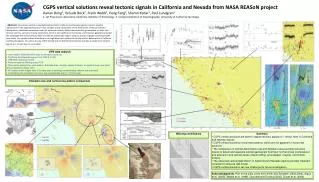
GRWS Analysis JPL/SIO combination includes nearly complete set of Western North America sites over the last decade+
GRWS Centralized Storage Oracle RDBMS Common data models Well-defined integrity constraints
GWRS Exploration Time Series CRTN Visualization Extraction Subscription User notification Summarization Education
GPS Explorer SOMI v5.0 http://reason.scign.org
GPS Explorer SOMI v5.0 http://reason.scign.org
GPS Explorer SOMI v5.0 http://reason.scign.org
GPS Explorer SOMI v5.0 http://reason.scign.org
GPS Explorer SOMI v5.0 http://reason.scign.org
GRWS Now serving • Over 10 years of data for ~500 western US CGPS stations. • Dynamic, web-accessible source for vetted GPS solution “input” metadata in XML format. • Rigorous weekly GPS combination using ‘st_filter’ of data from (1) and metadata from (2). • Sophisticated TimeSeries Applet with full suite of combination components from (3). • Advanced online spatio-temporal visualization tool (SOMI) to be incorporated into ongoing portal development. http://reason.scign.org
GRWS Currently developing • Additions to Service Oriented Architecture for combined GPS solution product delivery, registration, request & retrieval • Web-accessible components for portal development • Prototype framework for GPS Explorer, a public portal for online GPS-related analysis, science, teaching and discovery • Machinery to enable complete, on-demand re-processing • Public, queryable project metrics and usage interface http://reason.scign.org
REASoN Data Portal http://geoappdev01.ucsd.edu:8080/scignDataPortal/coordQuery.jsp http://reason.scign.org
GRWS Moving towards Full automation of... • Outlier removal • Quality reporting • Regional filtering • Spatial coherence detection • Integration with modeling databases (QuakeSIM) • Velocity & strain map generation • Sub-daily and real-time solutions and the public release of GPS Explorer. http://reason.scign.org
New NASA IT Effort • Merge three related projects under one frame work (2006-2008+) • SCIGN-REASoN (2004-2008) • Combination, validation, archive, and delivery of high-level data products and data mining capabilities from space geodetic measurements, specifically continuous GPS (CPS) observations. • QuakeSim (2003-2006) • Development of linked Web service environments for supporting high performance models of crustal deformation from a variety of geophysical sensors, including GPS and seismic instruments. • SENH-Applications GPS/Seismic integration (2003-2005) • Development of a prototype real-time GPS/seismic displacement meter, for use by local agencies responsible for seismic hazard mitigation and monitoring of critical infrastructure. http://reason.scign.org
Modeling and On-the-fly Solutions for Solid Earth Sciences (MOSES): 2006-2009 http://reason.scign.org
Summary • Web service and portal developments • Moving forward • Developing components and tools • Combination • Moving forward • Web services are being tested and integrated as they become available • Processes for verification and validation of solutions are maturing • Combined solution generation • At will • Coordinates are being posted/delivered • Velocities (July ’06) • Integration of other center’s solutions are being considered • Looking beyond REASoN Program • MOSES project • GRWS development http://reason.scign.org/ http://reason.scign.org