Download
1 / 46
460 likes | 621 Vues
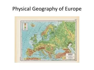
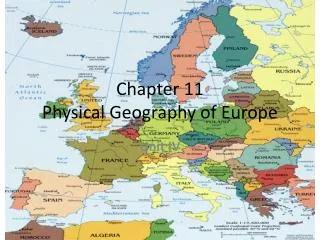
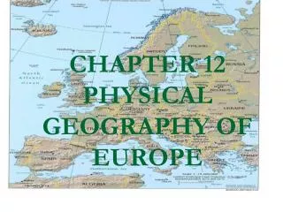
Physical Geography of Southern Europe. 4.1. How many peninsulas do you see?. Peninsulas. Peninsula- (Q1.1) land surrounded by water on 3 sides (Q1.2) Europe is a large peninsula jutting out of Asia, and is made up of numerous smaller peninsulas Southern Europe is made up of 3 peninsulas

E N D
Peninsulas • Peninsula- (Q1.1) land surrounded by water on 3 sides • (Q1.2) Europe is a large peninsula jutting out of Asia, and is made up of numerous smaller peninsulas • Southern Europe is made up of 3 peninsulas • (Q2.1) Iberian- Spain, Portugal • (Q2.2) Italian- Italy • (Q2.3) Balkan- Greece
Features • Southern Europe also known as (Q3) Mediterranean Europe • All three regions have (Q4.1) long coastlines along the Mediterranean Sea • (Q4.2) Are covered with rugged mountains
Mountains of Southern Europe • Mountains dominate landscape, (Q5) have made farming and travel difficult in the region • Four major mountain chains • (Q6.1) Pyrenees- form boundary between France and Spain • (Q6.2) Apennines- run along the Italian Peninsula • (Q6.3) Alps- highest mountains in Europe, in Northern Italy • (Q6.4) Pindus- cover most of Greece
Mountains Continued • (Q7.1) Mountains extend into the seas, rise up to form islands- 2000 in the Aegean Sea • (Q7.2) Crete- large mountain island south of Greece • (Q7.3) Sicily- large mountain island at southern tip of Italy
Other Seas • Mediterranean is made up of numerous other seas • (Q8.1) Adriatic Sea- east coast of Italy • (Q8.2) Ionian Sea- southwest of Greece • (Q8.3) Aegean Sea- east of Greece • Seas have been important because they (Q9)provide food and easy travel for Southern Europeans
The Plains • (Q10.1) Flat plains lie along the coast line and in river valleys, most people live here • (Q10.2) This is where most farming happens
2 Major Rivers • Are many rivers in region • 2 Major • (Q11.1)Tagus- longest river in the region • crosses the Iberian Peninsula • (Q11.2)Po River- starts in Northern Italy- • One of most fertile areas in Southern Europe • Most densely populated area in Southern Europe
Climate • Region is famous for its Climate • Is actually called Mediterranean Climate • (Q12) Warm, sunny, generally mild • Hot, dry summers, rain during mild winters • Climate allows for a (Q13.1) variety of crops to be grown: citrus, olives, grains • (Q13.2) Helps lead to tourism
Children of the Sea • (Q14.1) Seas provide for fishing industry- food and jobs • (Q14.2) Largest Cities are port cities • Trade has been vital to the region since the beginning of time