Groundwater
Groundwater. In any area, most rocks below a particular depth are saturated. Hydraulic head combines pressure and elevation to give a useful variable that controls water flow. Water flows at different rates through different materials: larger holes-> faster flow; more holes ->faster


Groundwater
E N D
Presentation Transcript
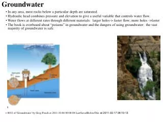
Groundwater • In any area, most rocks below a particular depth are saturated. • Hydraulic head combines pressure and elevation to give a useful variable that controls water flow. • Water flows at different rates through different materials: larger holes-> faster flow; more holes ->faster • The book is overboard about “poisons” in groundwater and the dangers of using groundwater: the vast majority of groundwater is safe. v 0032 of 'Groundwater' by Greg Pouch at 2011-10-04 00:00:09 LastSavedBeforeThis at 2011-02-17 08:10:13
Groundwater 3 Why Groundwater is Important Fluid Flow 4 Fluid flow > Hydraulic Head 5 Fluid flow > Darcy’s Law Description and Movement of groundwater in the subsurface 6 Vertical Distribution of Subsurface Water 7 Hydraulic Properties of Rocks and Soils 8 Rates of flow 9 Water table and topography Use of groundwater 10 Use of groundwater 11 Water Use > Quality 12 Geologic action by groundwater
Why Groundwater is Important • Direct Use of groundwater • About half the domestic water use in US is from groundwater. Varies regionally. • Why groundwater is good • much less subject to seasonal variations in availability than surface water • slow movement leads to high biological purity • temperature is remarkably constant • available virtually everywhere if you go deep enough • Stream flow usually comes from groundwater discharge, which means the other half of the water supply is from groundwater indirectly • Groundwater influences • weathering, • erosion, • mass wasting, • soil processes, • … • My PhD dissertation was on "Exploration for Shallow Groundwater in an Arid Environment using Directed Factor Analysis of Landsat Scanner Data"
Y h z Fluid flow > Hydraulic Head • At equal pressure (zero pressure), water flows towards lower elevation (downhill), but consider plumbing. • At equal elevation, water flows towards lower pressure. (Pipe to faucet), but consider swimming pool • Therefore, neither pressure nor elevation completely controls water flow, but they're both involved. • Hydraulic Head extends the elevation to include pressure. h = z + = z + P/g where • h is hydraulic head above some datum, such as sea level, • z is the elevation of the point of measurement, • is the pressure expressed as depth of water, • P is pressure • is the density of water • g is the acceleration of gravity. Using atmospheric pressure as P=0 and sea level as z=0, hydraulic head is the elevation at which water stands in a tube open at the bottom (sampling point) and top. Water (of like composition) flows from high to low hydraulic head. Open-channel flow and plumbing examples both work with h If you measure water level in a well, the elevation is the hydraulic head. The hydraulic head in an open body of water is the elevation of the water surface. As you go deeper in a body of water, the elevation decreases and the pressure increases. • Piezometric surface: a surface of hydraulic head in a connected zone. The water table is the piezometric surface in the top unconfined zone. • Water table surface where pressure is zero. When you’re digging, the water table is the level at which water will stand in a hole. There may be saturated material above it.
Fluid flow > Darcy’s Law • Hydraulic gradient h/l is the change in hydraulic head with respect to distance. It is a lot like the slope of the water table or other piezometric surface • Darcy’s law : q=Q/A =-K(h2-h1)/L= -K h/l • q is water flux in m/s, • h is the change in hydraulic head (m), • l is the distance over which it occurs (m), and • K (hydraulic conductivity) is a material constant (m/s). Darcy’s law is an empirical observation, and appears to apply over most common ground and soil water situations. At high gradients and velocities (such as in caves), turbulence becomes important and this breaks down. At low enough gradients, water might not move at all (but how do you show that?) • Effective velocity • q is flux, not actual velocity. • v=q/ v is effective velocity, and is porosity as a fraction (0 to 1) • Suppose over the course of an hour, 0.25 inches of hail falls. There was not a slow-moving parade of hail which advanced 0.25 inches/hour. The raindrops occupy a small area but move quickly at some average velocity, but the flux of water is 0.25 inches/hours tells you how much hail came down. On the other hand, figuring out whether you would get hail damage would require knowing how fast the hailstones were moving (and how big they were, which is where this analogy breaks down.). You can also consider the flux of cars going past some point on road, compared with the velocity of the cars. Both are important, and both LOOK like speeds.
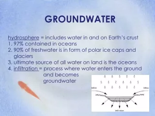
Vertical Distribution of Subsurface Water Subsurface water can be divided into zones, based on hydrologic parameters. One important division is saturated vs. unsaturated (with water). Water flows more slowly in an unsaturated medium under a set of gradient and material conditions than it would in a saturated medium, because the large pores drain first, and water flows fastest in the large pores. • Saturated: all pore space is filled with water • Unsaturated: some pore spaces have air and flow velocities are low. Another important division is based on the pressure of the water, because this controls whether or not water will flow into a well or house or other air-filled space.. Pressure measured relative to atmospheric pressure is called gage pressure. Negative gage pressure (suction) indicates absolute pressure below atmospheric. Positive gage pressure indicates absolute pressure above atmospheric. Water can flow horizontally from a material under positive gage pressure to an area of zero gage pressure. • Phreatic: water has positive (gage) pressure. Below the water table. • Vadose: water has negative (gage) pressure. Above the water table. • Water table is boundary between vadose and phreatic zones: gage pressure is zero at water table. • Capillary fringe is in equilibrium with water table. It lies entirely in the vadose zone and includes both saturated and unsaturated parts. The water table is very easy to find. However, water will slowly flow (mainly by evaporation) into an area in contact with the saturated part of the capillary fringe, so allowance needs to be made in siting buildings. • Artesian piezometric surface is above the top of the aquifer. • Flowing means that the piezometric surface is above the land surface. • In the near subsurface, groundwater is fresh. As it flows along it picks up ions from weathering, and becoming saltier. • In the deep subsurface, most groundwater is brine (about 10X saltier than seawater.) and seems to be not in flow, unless disturbed.
Hydraulic Properties of Rocks and Soils • Porosity fraction of rock occupied by pore space. Easy to determine. Varies from as little as 0.5% in unweathered igneous rocks to as much as 50% in some soils. 10-30% is common in sediments. • Hydraulic conductivity K Material 'constant' in Darcy’s law that influences speed of flow. Hard to measure. Varies tremendously (8 orders of magnitude easily). The variation in permeability is, ultimately, the main employment of geologists. • Storativity is the ratio of depth of water released to drop in head If this is close to a porosity (0.2), it’s called specific yield and indicates unconfined conditions. If it’s close to the compressibility of water (0.00005), it indicates confined conditions. • Unconfined water release is due to gravity drainage. Usually, only the uppermost aquifer is unconfined, unless you have a perched water table. • Confined water release is due to expansion of water and formation. Typically involves an “impermeable” confining layer • Specific yield is the volume fraction of water released from the material when it is drained. • Specific retention is the amount still held in storage • A pump test involves pumping from a withdrawal well and observing the declines in head (and there's lots of differential calculus involved): this is how we measure hydraulic parameters, but it's expensive, and not as useful as it seems since the mathematical models are over-simplified and many possible combinations of properties can give rise to the same observations. • Mapping permeability distributions is essential to understanding, using, and protecting groundwater. This is done by correlating well logs, drilling, and geophysics. • Permeability distribution also controls the occurrence of oil and hydrothermal-related ore deposits. • Most professional activity by a geologist centers on mapping permeability distributions.
Rates of flow • Typical bulk groundwater flow rates range from 0.01 m/yr to 100 m/yr, mostly in the low range. Because much groundwater flow is channeled, the actual rates of flow are often much higher or lower. • Permeability varies tremendously. Clean sandstone may have K=0.1 m/s, while clay can have K=1E-10 m/s. • Most of the movement happens in the most permeable materials, and the bulk of most materials act as storage. (It’s sort of like roads and parking lots/street parking). These are situational terms. • Aquifer a layer that yields sufficient water to be worth pumping. Should be permeable. • Aquitard the opposite of an aquifer, it does not yield enough water to be worth pumping. • Because a unit worth pumping is an aquifer, it's rare bordering on impossible to NOT be above an aquifer.
Water table and topography • Spring: place where the water table intersects the land surface and water flows out. Usually this is a seep if slow enough. Most stream beds are springs. • The water table outcrops at lakes, ponds, most streams • Streams can get water from or put water into the groundwater system. Usually, streams get water from groundwater. In deserts, upland streams (gullies, wadis, and alluvial fans) lose water to the subsurface, which then flows out at the main stream. Water table is almost always closest to the surface at streams, under natural conditions
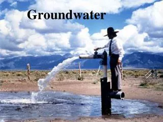
Use of groundwater • About half the domestic water use in US is from groundwater. Varies regionally. • Why groundwater is good • much less subject to seasonal variations in availability than surface water • slow movement leads to high biological purity • temperature is remarkably constant • available virtually everywhere if you go deep enough • Drawdown: depression of a piezometric surface (including water table) due to pumping. Since pumping water out means lifting it, this is important. • Cone of depression is lowering of piezometric surface due to pumping around a well. Much more depressed near the well and less depressed further away. For a given amount of water withdrawal, the shape (width vs. depth) depends on hydraulic conductivity, storativity, and layer thickness. Other things being equal, a higher-permeability aquifer will have a broader, shallower cone of depression. A higher-storativity aquifer will also have a broad, shallow cone of depression. A thicker aquifer has a broader, shallower cone of depression. (This is part of why pump tests are hard to interpret.)
Water Use > Quality Groundwater picks up dissolved weathering products, and sometimes deposits them. Metals present in the rock the water flows through can end up in the water. Mostly, water picks up calcite and dolomite, but also Na, minor Cl, SO4, and some potassium. In some areas, there can be other elements found in small quantities chemically but that are significant biologically, like arsenic and lead. • Potential Problems The book greatly exaggerates the severity of problems associated with ground water. The vast majority of groundwater is safe to drink. Most really un-drinkable water is associated with the immediate vicinity of gas stations or other hydrocarbon storage facilities, or military bases. • Declining water levels • Saltwater contamination from brines or seawater below • Subsidence (rare, usually only occurs in young, unconsolidated sediments that have not been dried before) • Groundwater contamination (biologic and chemical)
Geologic action by groundwater • Weathering and cementation In the course of its travels, groundwater can dissolve and precipitate a lot of material, mainly calcite and quartz. Most cementation of sediments occurs due to mineral deposition by groundwater. It also plays a large role in fossil formation and preservation. Groundwater is why there are sedimentary rocks and why weathering happens not only at the surface. • Karst: Erosion by groundwater (book covers this well) Calcite is soluble in acidic water, and since water is acidic from CO2 in the atmosphere and soil, the groundwater dissolves limestone and dolomite. This widens any joints the water is flowing through, resulting in more water flowing through, etc, until you have a cave, which eventually collapses, leaving a sinkhole. At the land surface, the areas that haven’t collapsed are left behind, and often form haystacks (circular hills). Vanishing streams and spectacular springs are common.
Groundwater • Rocks contain pores, mostly filled with water. Near the surface, some are filled with air. • The water table defines the boundary between saturated 'rock' with pressure above and below atmospheric pressure. In the saturated capillary fringe, the 'rock' is still saturated, but held in tension. Very deep groundwater has lots of salt (10X seawater), and is called brine. • Water flows from high to low hydraulic head (combines pressure and elevation), usually according to Darcy's Law. Permeability influences how fast water flows through 'rock'. Water flows at different rates through different materials: larger holes-> faster flow; more holes->faster flow • Groundwater • feeds streams, • moves calcite and silica cement for lithification, • corrodes carbonates to produce karst terrain • Directly provides half the US's drinking water supply