Download
1 / 52
600 likes | 828 Vues
General Description of coastal hydrodynamic model. Waves WAVEWATCH III. l -> k-l, k- e. Characteristic of a coastal Hydrodymic model. Bathymetry. Tide. Wind. Mesoscale circulation. WRF. Currents. Turbulence. Sediment transport Mud Model Sand Model.

E N D
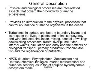
General Description of coastal hydrodynamic model
Waves WAVEWATCH III l -> k-l, k-e Characteristic of a coastal Hydrodymic model Bathymetry Tide Wind Mesoscale circulation WRF Currents Turbulence Sediment transport Mud Model Sand Model
Necessity of the data and measurements A coastal model must represent the reality as soon as possible. It’s link to the other objectives developed on the study area. From the different point of view we need: Define the forcing Collecting existing data Initiate a strategy of measurement
Example of strategy of measurement Meteorological stations Tide recorders Currentmeter moorings CTD profiling Doppler profiling Wavemeter
Tide analysis from tidegauge Amplitude in m. Phase in degree
Tide analysis from classical currentmeters Amplitude in m.
2. Residence times Lagrangian Tracors
2. Residence times e-flushing time Method: concentration of one tracer Case : trade wind de 8 m/s + marée Evolution of the concentration in 1 point(example) Simulation without tide
2. Residence times Jouon, Douillet, Ouillon & Fraunié, 2006, Continental Shelf Research, 26, 1395-1415
3. Dissolved transport Tide Bottom
3. Dissolved transport Tide Surface
3. Dissolved transport Trade W Bottom
3. Dissolved transport Tide Bottom
4. Particle Dynamics C : Suspended Sediment Concentration of a given grain size / population u, v, w : water velocity provided by the hydrodynamic model Kh : horizontal diffusivity Kz : vertical diffusivity from kinematic turbulent viscosity Mathematical model General equation of suspended particle transport In Open boundary conditions Out Surface boundary conditions
4. Particle Dynamics cd, ce : critical shear stresses for deposition and erosion ke : erosion rate coefficient Mathematical model : cohesive particles (Mud) Fall velocity (Ds < 100 m) : Stokes’ formula where Bottom boundary condition Deposition (Krone, 1962) Erosion (Parthéniades, 1965) where : shear stress provided by hydrodynamic modelling cd, ce : critical shear stresses for deposition and erosion ke : erosion rate coefficient
4. Particle Dynamics Ex: Dumbea Bay Application to the southwest lagoon of New Caledonia : Particle Diameter 3 coarse kinds of sea bottom (Chardy et al., 1988)
4. Particle Dynamics Application to the southwest lagoon of New Caledonia: Calibration Estimate of a global critical shear stress under tide + trade wind forcings averaged % of mud