Download
1 / 2
World War I Map – Schlieffen Plan
100 likes | 481 Vues
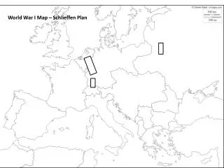
World War I Map – Schlieffen Plan. Map of Europe in 1914 Label the following on your map: Britain Shade Central Powers Red France Shade Allied Powers Blue Russia Italy Germany Ottoman Empire (Turkey) Diagram the German plan to attack France
Télécharger la présentation 
World War I Map – Schlieffen Plan
An Image/Link below is provided (as is) to download presentation
Download Policy: Content on the Website is provided to you AS IS for your information and personal use and may not be sold / licensed / shared on other websites without getting consent from its author.
Content is provided to you AS IS for your information and personal use only.
Download presentation by click this link.
While downloading, if for some reason you are not able to download a presentation, the publisher may have deleted the file from their server.
During download, if you can't get a presentation, the file might be deleted by the publisher.
E N D
Presentation Transcript
Map of Europe in 1914 Label the following on your map: Britain Shade Central Powers Red France Shade Allied Powers Blue Russia Italy Germany Ottoman Empire (Turkey) Diagram the German plan to attack France Austria-Hungary Label percentages and provide troop movements Bulgaria Switzerland Spain Denmark Sweden Netherlands Finland Atlantic Ocean Mediterranean Ocean English Channel North Sea Baltic Sea Aegean Sea Adriatic Sea Black Sea Marne River Paris


More Related