Download
1 / 5
50 likes | 167 Vues
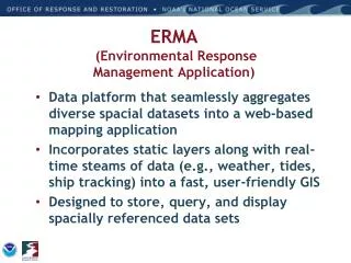
ERMA (Environmental Response Management Application) is a powerful open-source web-based tool designed to facilitate the integration, visualization, and analysis of diverse environmental data. It enhances communication and coordination in response efforts and situational awareness, providing real-time updates on weather, hazardous materials, and protected resources. With secure server access, users can download and upload data, access various datasets, and visualize current incidents through animated layers. ERMA supports environmental recovery, restoration, and response planning across different regions including the Caribbean, Gulf of Mexico, and Arctic.

E N D
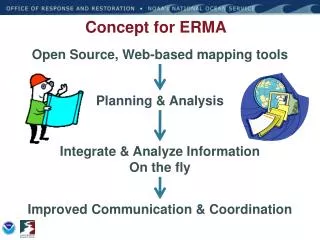
Concept for ERMA Open Source, Web-based mapping tools Planning & Analysis Integrate & Analyze Information On the fly Improved Communication & Coordination
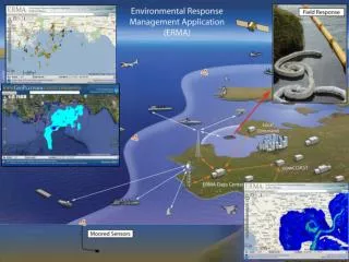
Output to User Download/Upload Source Feature Server Tools ERMA Architecture ESI & IPaC Query AIS Ship Search Open Layers Web Mapping Service (Feature) • External GIS Data • ENCs/ RNCs • Real Time Weather Obs • Buoys • NAIS/ AFF/AMOC Secure Server Authentication Data Layer Management Access Privileges • Response datasets from SFTP • Trajectories • Satellite Interpretations for oil • SCAT Results • Overflight Planed & Obs • Booms plans/derived from imagery • Protected Resource Impact • Field sampling (subsurface, analytical chemistry, etc.) • Platform observations MapServer • Base Public datasets • ESI • Landuse • Bathymetry • Regional Monitoring • Habitat Classifications • Restoration • Bioresource Base data PostGres/ PostGIS Data Base (Full Backup routinely)
Site Overview • Weather & Buoys Observations • Real-time feeds • Hurricane/Storms • Remote-sensing Imagery • Resources at Risk • NOAA ESI data layers • Fisheries Closures • Local habitat and species datasets • Seafood Safety • Marine Protected Areas • Document & photo links • ESI and GRPs PDFs • Field Photos • External links • Secure access • Username/Password • Various levels of access (Public, Responder, NRDA, Trustee) • Background Layers • Google aerial, terrain, roads • Nautical charts • Incident information • Trajectories • Field teams, aircraft, and vessel tracking • Shoreline Oiling • Geographic Response Plans Priorities • Analytical Chemistry Data
Current ERMA Development • New England (SONS) • Caribbean – US territories, Groundings, Haiti • GOM & DWH MC252 • Puget Sound WA – Focus on climate change impacts • Pacific Islands – In development, FY ‘11 • Arctic – NOAA OCRM Energy Initiative • Lake Champlain – funded FY ‘11 • NJ/ NY Harbor w/EPA R2 • West Coast
ERMA Functionality and Applications • ERMA is designed to: • Assist with environmental response preparedness • Assist in coordinating response efforts and situational awareness • Can help to define the extent of potential impacts and NRDA • Assist in Recovery and Restoration • ERMA can: • Be accessed from anywhere you have an internet connection • Visualize data from a variety of sources complete with metadata (including field photos, linked scientific reports, etc.) • Tell a story or event history using animated layers • ERMA next steps: • Expand coverage/ funding partners • Serve from the cloud • 3-D visualization plug in • ????