Download
1 / 46
460 likes | 477 Vues
Explore the key features that characterize rivers, including discharge, velocity, channel configuration, gradient, and sediment movement. Understand the formation of stream valleys, channels, floodplains, and delta formations. Learn about different drainage patterns and how they shape river networks.

E N D
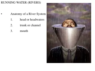
RUNNING WATER (RIVERS) • Anatomy of a River System 1. head or headwaters 2. trunk or channel 3. mouth
• 5 features that characterize all rivers • 1. discharge - volume of water flowing by a point in a given period of time
• 5 features that characterize all rivers 2. velocity i. laminar vs. turbulent flow
(1) in addition to velocity, the depth and viscosity of the water determines whether water flow is laminar or turbulent • (a) laminar - shallow and smooth channel, viscous and slow moving fluid • (b) turbulent - deep and rough channel, less viscous and fast moving fluid
• 5 features that characterize all rivers 3. channel configuration
• 5 features that characterize all rivers 4. gradient - slope of stream i. shape is concave upwards (why?)
ii. longitudinal profile - due to... (1) topography (2) climate (3) stream flow (4) resistance of rock to erosion (5) base level (a) ultimate base level? (b) intermediate base levels?
• 5 features that characterize all rivers 5. load - what it carries
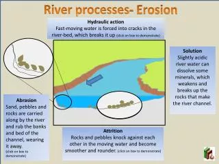
• Sediment Movement - dependent upon type of flow 1. Erosion and transport i. erosion occurs due to: (1) abrasion (2) chemical and physical weathering (3) undercutting
ii. transportation of sediment can be broken into: • (1) suspended load • (2) bed load • (a) competence - the size particles that a stream can move • (b) capacity - total volume of sediment that a stream can carry • (3) dissolved load
• Sediment Movement - dependent upon type of flow • 1. Erosion and transport • iii. saltation - a particle is picked up when turbulent forces are great enough, and dropped when they decrease slightly
• Sediment Movement - dependent upon type of flow • 1. Erosion and transport • settling velocity - speed at which particles settle to the bottom of a channel • v. Dunes and ripples - form at the bottom of a channel and represent sediments that are in transit (requirements ?) • (1) gentle slope faces upstream, and steep slope faces downstream
• Stream Valleys, Channels and Floodplains • 1. stream valleys are the entire area from the top of the slope on one side of the river to the top of the slope on the other • i. usually V-shaped
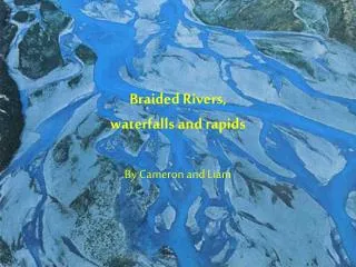
• Stream Valleys, Channels and Floodplains • 2. channels are the trough along the bottom of the valley that in which the stream flows • i. channels can have patterns that are nearly straight to extremely circuitous
• Stream Valleys, Channels and Floodplains • ii. most streams that flow across flat areas develop curves that are called meanders • (1) not well understood, but once they start they migrate across the floodplain due to differences in the streams flow and velocity in the channel
• Stream Valleys, Channels and Floodplains • (2) velocity is greatest on the outside of the bend, this cuts into the bank on the outside bend and the river migrates in that direction
• Stream Valleys, Channels and Floodplains • (3) at the same time, the slower flow around the inside of each bend allows the stream to deposit a part of its load on the point bar
• Stream Valleys, Channels and Floodplains • (4) oxbow lakes are created when a meander encounters its own course and cuts itself off from the rest of the river
• Stream Valleys, Channels and Floodplains • 3. floodplains are the flat area along either side of the channel onto which water overflows during a flood • i. produced by the migration of the river
3. floodplains are the flat area along either side of the channel onto which water overflows during a flood • ii. during floods, the overflowing water rapidly loses energy as it escapes from the channel thereby depositing sediments on the nearby floodplain
3. floodplains are the flat area along either side of the channel onto which water overflows during a flood • iii. the greatest amount of sediment is deposited adjacent to the channel thereby creating a natural levee
• Stream Valleys, Channels and Floodplains • 3. floodplains are the flat area along either side of the channel onto which water overflows during a flood • iv. if the natural levee get too big, it can constrict and confine the rivers course
NOTE: SINCE THE FACTORS THAT CREATE RIVER FEATURES ARE DYNAMIC, RIVERS CHANGE WITH TIME.....AND DISTANCE • v. examples: longitudinal profiles and recurrence intervals
• Drainage Networks 1. a ridge that separates two streams serves as a divide
• Drainage Networks 2. divides establish drainage basins 3. stream piracy
• Drainage Networks • 4. drainage patterns show the shape and interconnection of streams and tributaries that form a particular drainage network
5. types of drainage patterns • i. dendritic - most popular and resembles the root system of a tree (uniform bedrock)
5. types of drainage patterns ii. rectangular- faulting controls runoff
5. types of drainage patterns iii. trellis - folding controls runoff
5. types of drainage patterns iv. radial - mountains or hills control runoff
• Delta's • 1. all streams eventually empty into a large body of standing water and as the streams current dies, sediment is deposited
• Delta's • 2. as the stream becomes an obstacle to flow, the streams course changes and forms lobes of the delta
• Delta's • 3. the stream deposits its heaviest load near the mouth and carries the finer material out to sea