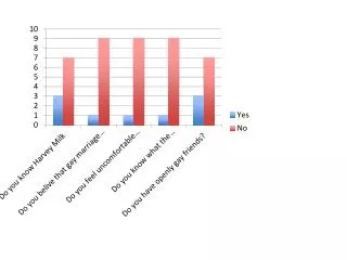
Electronic Chart
Electronic Chart. Solas Chapter V Regulation 27. Nautical chart and nautical publications Nautical charts and nautical publications, such as: sailing directions, list of lights, notices to mariners, tide tabels and other nautical publications necessary for the intended.

Electronic Chart
E N D
Presentation Transcript
Electronic Chart Per R. Bodin
Solas Chapter V Regulation 27 Nautical chart and nautical publications Nautical charts and nautical publications, such as: • sailing directions, • list of lights, • notices to mariners, • tide tabels • and other nautical publications necessary for the intended Per R. Bodin
Solas chapter V Regulation 2 Definitions 2. Nautical Chart or nautical publication is a special-purpose map or book, or a specially complied database from which such a map or book is derived, that is issued officially by or on the authority of a Government, authorised Hydrographic Office to meet the requirements of marine navigation. Per R. Bodin
Example hazards • Minor • Interruption to navigation information • Reduced ECDIS functionality • Increased navigation workload • Major • Severe disruption to navigation information • Loss of alarm functions • Unable to continuosly monitor vessel`s position • Difficulty in maintaining planned track • Critical • Total loss of navigational information • ECDIS failure Per R. Bodin
Electronic chart are here to stay • International legislation is complete • Revised equipment approval standards agreed and published • National legislation requirements are being refined • Paper chart sales are predicted to have peaked Per R. Bodin
Why og electronic • Integration with other sensors • Simplifies route planning • Effective route monitoring • Comprehensive recording • Simple application of updates • Updates by satcoms and telephone • More intelligent systems • Increased safety Per R. Bodin
ECDIS • IMO Performance Standar (1995) • Resolution A.817 (19) • IHO Transfer Standards for Digital Hydrographic Data • S57 Edition 3.1 (2000) • International Electrochnical Commission Ecdis Oerformance Standards, Methods of Testing and Required Test Results • IEC 61174,2nd Edition (2001) Per R. Bodin
RENCS • Regional Electronic Navigational Chart Co-ordinating Centres • In Europe there are two such centeres: • International Centere for ENCs • Primar - Stavanger Per R. Bodin
Electronic charts are here to stay • International legislation is complete • Revised equipment approval standards agreed and published • National legislation requirements are being refined • Paper chart sales are predicted to have peaked Per R. Bodin
Basic formats of electronic charts • Raster Chart • Data is ”dot” equivalent of printed image • Arranged in rectangular grid of pixels • Each pixel is geographically referenced • Vector Chart • Data is ”ordered” list of features • Data is geographically referenced • Data items have attributes Per R. Bodin
Terminology • Electronic Chart Display and Information System (ECDIS) • Specific vector shart system defined by IMO/IHO • Electronic Navigational Chart (ENC) • Official HO approved vector data for ECDIS • Raster Chart Display System • Raster chart system meeting IMO requirements • Raster Navigational Chart (RNC) • Official HO approved raster data for RCDS Per R. Bodin
Non-approved electronic charts • Electronic Chart System (ECS) • An electronic chart system which does not meet IMO`s standards or an approved system which is displaying data which does not meet ENC/RNC standards Per R. Bodin
Maritime Administrations Administrations have been taking a cautious approach to the use of electronic charts: • Legislation issues prior to revised SOLAS Ch. V • Unhappy with First Edition of IEC 61174 for Type approval of equipment • Limited ENC coverage • Wanted more RCDS experience • Wanted more experience regarding back-up • Experience has been gained though controlled use under IMO 15 regulations Per R. Bodin
Scenario for the immediate future Maritime administrations will: • Insist on full use of paper charts for ECS operation (as is presently the case) • Where there is adequate coverage of ENCs allow non-paper operation if back-up meets their requirements, eg by formal risk analysis or inspection • Allow RCDS operation, if ENCs are not available, with parallel use of (generally) smaller scale paper charts (in accordance with administrations`requirements or by formal risk analysis) Per R. Bodin
RCDS mode of operation In 1998 IMO MSC70 adopted amendments to the original ECDIS resolution: • Permits RCDS mode of operation when ENC data is not available • ”When operating in the RCDS mode, ECDIS equipment should be used together with an appropriate portfolio of up-to-date paper charts” • So called ”dual-fuel” operation Per R. Bodin
SOLAS Chapter V Regulation 19 Carriage requirements for shipborne navigational systems and equipment • 2.1 All ships irrespective of size shall have: • 4 nautical charts and nautical publications to plan and display the ship`s route for the intended voyage and to plot and monitor positions thoughout the voyage; an Electronic Chart Display and Information System (ECDIS) may be accepted as meeting the chart carriage requirements of this subparagraph; Per R. Bodin
Solas Chapter V • New Chapter V (Safety of Navigation) • Comes into force 1 July 2002 • Explicitly includes references to ECDIS Per R. Bodin
Risk assessment method • Determine hazards, ie what could cause harm • Determine the risk • Risk= severity x likelihood • Decide if risk is tolerable • Otherwise develop procedures to control the risk • Review the risk • Will controls lead to a tolerable risk and are they practicable • Develop emergency procedures Per R. Bodin
Risk assessment Increased support by marine administrations of risk Assessment techniques to identify the hazards and hence determine the safe configuration and use of electronic charts and their back-up, considering: • Type of vessel • Operational area • ECDIS specifications Per R. Bodin
Back-up solutions IMO Resolution MSC.64(67) – 1996 • Carriage of an additional type approved ECDIS • Reversion to paper charts • Reversion to a non-ECDIS electronic chart system • Meeting minimum requirements • Data issued by a national HO Per R. Bodin
Alarms and indicators • Alarm Exceeding off track limits VR • Alarm Crossing safety contour V • Alarm/indication Area with special conditions VR • Alarm Deviation from route VR • Alarm Positioning system failure VR • Alarm Approach to critical point VR • Alarm Different geodetic datum VR • Alarm/indication Malfunction of chart system VR • Indication Information overscale VR • Indication Larger scale data available VR • Indication Route planning across safety contour / specified area V • Indication Positioning system accuracy VR Per R. Bodin