Download
1 / 24
260 likes | 442 Vues
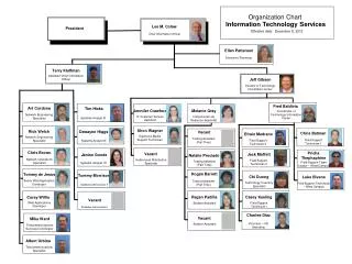
International Hydrographic Organization Electronic Navigational Chart (ENC) - ENC Coverage Analysis - Captain Robert Ward, Director IHB. “adequate coverage”.

E N D
International Hydrographic Organization Electronic Navigational Chart (ENC) - ENC Coverage Analysis - Captain Robert Ward, Director IHB
“adequate coverage” “ ….. those ENCs required to enable safe port to port navigation for international shipping that correspond to the paper chart coverage for these ports and the routes between ”
“adequate coverage” Focus on international trade routes • Major ports • Major trade routes
Top 800 Ports and Major Trade Routes Source: Lloyds statistics
Coverage Comparison - June 2008 Paper Charts ↔ ENCs
ENC Coverage : June 2008 Published ENCs
ENC Coverage : 2008-2009 Published ENCs Confirmed in Production
Growth in Availability- ENCs Available to Purchase other undeclared production programs Additional ENCs awaiting validation - at least 1500 8400 (26 June 08)
Coastal States: …..Will your international ports and routes be covered by ENCs in 2010? State will complete ports and routes by 2010 State will complete ports and routes by 2010 with assistance No information provided (as yet)
Global ENC Production Initiatives • Regional cooperation (RHCs) • Bi-lateral assistance and production programs • Australia, France, Netherlands, New Zealand, Norway, Portugal, UK, ….. others
Global ENC Production Initiatives • Capacity Building • IHO technical assistance programmes • Asia Development Bank • Papua New Guinea • IMO/IHO/Global Environment Foundation • Marine Electronic Highway - Singapore and Malacca Strait • Marine Highway - SW Indian Ocean • UKHO ENC Program
“adequate ENC coverage” Prediction - end 2010 Paper Charts ↔ ENCs
IHO Statement to IMO: Adequate ENC coveragewill be achieved by 2010
IHO ENC Coverage Catalogue • Requested by IMO • ENCs commercially available • RNCs commercially available • State by State requirements (if any) for paper charts used in conjunction with ECDIS • links to State on-line catalogues (where they exist) • Database sources: • RENCs • Individual States • VARs
About ENCs www.iho.int
ENC Identifier Compilation Scale Metadata Link
Conclusion Adequate coverage of ENCs will be available by 2010 IHO ENC Catalogue of coverage now on internet IHO is monitoring ENC coverage and reporting annually to IMO