Download
1 / 54
540 likes | 901 Vues
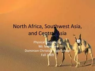
North Africa, Southwest Asia, and Central Asia. Physical Geography Mr. Marston Dominion Christian High School Fall 2009. Chapter Objectives. 1. Major landforms and natural resources 2. Climate and Vegetation. Maghreb and the Middle East. PersiaGulf. Red Sea. Arabian Sea. Gulf of Aden.

E N D
North Africa, Southwest Asia, and Central Asia Physical Geography Mr. Marston Dominion Christian High School Fall 2009
Chapter Objectives • 1. Major landforms and natural resources • 2. Climate and Vegetation
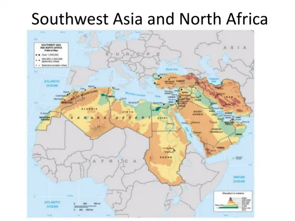
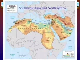
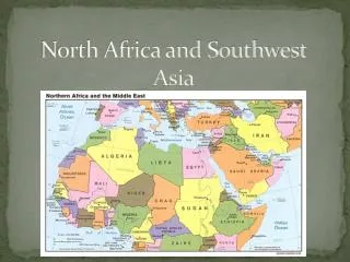
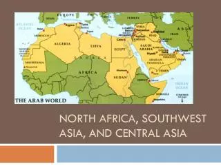
Maghreb and the Middle East PersiaGulf Red Sea Arabian Sea Gulf of Aden
Divisions • 1. Maghreb: area of North Africa between the Atlas Mountains and the Mediterranean Sea. • Maghreb means “western” in Arabic. • The Countries have similar • Climates • Landforms • Populations • Economies • history
Maghreb Union • The joining together of the North African countries in 1989. To: Promote economic cooperation Economic integration Morocco Algeria Tunisia Libya Mauritania
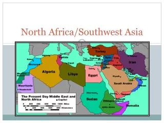
Divisions II • 2. Middle East • Arabian Peninsula • Iran and Turkey 3. Central Asia
Key Geographic Points • Bosporus Strait: separates Asia and Europe • Dead Sea: forms Israeli-Jordanian border • Caspian Sea: largest inland body of water on earth • Aral Sea: once the 4th largest inland sea, it is now drying up.
Floating in the Dead Sea: Aaaaahhh. High Salt content contributes to buoyancy.
Caspian Sea: largest lake on earth. Oil and gas and sturgeon.
Aral Sea Shrinkage • Shrinkage
Nile River Delta • 90% of Egypt’s people live in Nile River Delta • They live on 3% of Egypt’s land • Aswan High Dam • Controls river flow • Reduces flooding • Alluvial soil: rich soil made up of sand and mud deposited by moving water.
Mesopotamia: “The land between two rivers” • Tigris and Euphrates Rivers in Iraq • The two rivers join to form the Shatt al Arab, which empties into the Persian Gulf
Wadis • Wadis: streambeds that remain dry until a heavy rain and often become dangerous after a heavy rain.
Plains, Plateaus, and Mountains • Coastal plains: fertile plains along the Mediterranean Sea (Moroccan and Algerian coasts and along the Caspian Sea and Persian Gulf) • Highlands: Atlas Mountains: 50% of Moroccan people engage in agriculture and produce, barley, oats, and wheat) Hejaz: mountain range on western coast of Arabian Peninsula Asir: area more agriculturally productive on Arabian peninsula because it gets more rainfall than the Hejaz
Other mountain ranges • Pontic (Turkey • Taurus (Turkey) • Caucasus • Zagros: southern Iran
Lowlands • Kums: dune covered deserts of Turkmenistan and Uzbekistan. • Garagum (black sand) • Qizilqum (red sand)
Earthquakes • African, Arabian, and Eurasian plates come together in the region. • As they clash: • Build mountains • Shift landmasses • Cause earthquakes Turkey: experiences regular earthquakes
Natural Resources • Petroleum: 70% of world’s oil reserves • Natural Gas: 33% of natural gas • Other: • Sulfate: (Paperboard, glass, detergents) • Phosphates: used in fertilizers • Chromium, gold, lead, manganese, and zinc • Iron ore
Potential for diversification • UAE: banking, information technology, and tourism. • Libya: invested in infrastructure, agriculture, and fisheries.
Climate and Vegetation Water scarcity defines the region’s climates Climates: Desert: predominates Steppe Mediterranean Highland
Sahara • Largest desert in the world • 3.5 million square miles • Desert:average less than 10 inches of rain per year • Sand covers less than 10% of the Sahara (barren rock, mountains, and desert pavement cover the most) • Desert encompasses about 50% of the lands in North Africa, Southwest Asia, an Central Asia.
Weather Patterns in the Desert • Central Asia/northern Sahara: cold winters with freezing temperatures • Southern Sahara/Arabia: winters are milder • Summers are long and hot. • Ergs: Sand dune covered areas • Regs: stony plains covered with rocky gravel called “desert pavement” • Hamada: flat, sandstone plateau
Rub al Khali • “Empty Quarter” • Located on the Arabian Peninsula • Some vegetation grows: cacti and drought resistant shrubs.
Steppe Climate • Second largest climate in the region of North Africa, Central Asia, and Southwest Asia • Steppe borders the Sahara to the north and runs from Turkey to eastern Kazakhstan • Precipitation averages less than 14 inches per year.
Pastoralism: the raising and grazing of livestock is a way of life for people in the steppes. • Bedouin Pastoralists
Climatic Variations • Mediterranean Climate zones: • Cool, rainy winters alternate with hot, dry summers. • Ideal for tourism • Export citrus fruits, olives and grapes to Europe and North America