Download
1 / 11
110 likes | 225 Vues
Improved Estimates of Aboveground Biomass using MODIS and the Geoscience Laser Altimeter System. Michael Lefsky Colorado State University Plinio Camargo University of Sao Paulo Warren Cohen USDA Forest Service David Harding NASA GSFC Michael Keller USDA Forest Service

E N D
Improved Estimates of Aboveground Biomass using MODIS and the Geoscience Laser Altimeter System Michael Lefsky Colorado State University Plinio Camargo University of Sao Paulo Warren Cohen USDA Forest Service David Harding NASA GSFC Michael Keller USDA Forest Service Robert KennedyUSDA Forest Service
The Problem • Biomass of the forests of the Amazon Basin is poorly known (Houghton et al. 2001) in part because no systematic sampling program covers the entire region. • Can remote sensing approaches help to resolve this problem? • Remote sensing alone is not enough.
Best Understanding of Biomass Y Malhi, Third LBA Scientific Conference, 2004
Filling Data Gaps • Use of the GLAS data may help to fill a gap left by the cancellation of the LBA Air-ECO campaign.
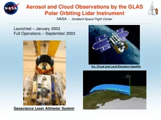
GLAS? • We propose to use lidar waveforms from the Geoscience Laser Altimeter System (GLAS) to estimate canopy height and aboveground forest biomass for each GLAS waveform in two study regions (the conterminous U.S. and the Amazon basin) and to combine those point estimates with images from the MODIS sensor to develop spatially continuous datasets of these same variables.
Does GLAS work? • Despite engineering problems with the GLAS sensor, over 300 million waveforms have been collected, with 2.4 million waveforms currently available for the conterminous U.S., and nearly 1 million for the Amazon basin. With no other global lidar data collection scheduled for the near future, GLAS data represents an important source of information on global forest canopy height and aboveground biomass.
What is GLAS? GLAS continuously fires laser pulses 40 times a second obtaining measurements from laser footprints spaced ~175 m along the nadir ground track. The continuous operation in ICESat’s near polar orbit obtains globally distributed measurements to ±86°. For each footprint, GLAS digitizes backscattered 1064 nm laser energy with a temporal resolution of 1 nsec, equivalent to a vertical sampling of 15 cm.
Will this work in tropical forests? • Work in tropical forests in Costa Rica with an airborne instrument (LVIS) indicates very strong correlation with structural indices such as height of median energy (HOME) and biomass (Drake et al. 2001).
Plan for Initial Field Tests • Collection of forest structure data including DBH, commercial and total heights in 4 LBA sites: • Manaus • Santarem • Juruena • Cangussu
SSC Requirements • Brazilian Counterpart – Plinio Camargo + • Local Counterparts – Niro Higuchi, Natalino Silva, Erich Collicchio, Carlos Passos • CNPq License to be requested • Training and Education – we will seek a Ph.D. student • Data Policy – we will obey