Download
1 / 8
80 likes | 212 Vues
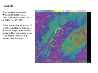
Case #1. Terrain background overlain With MODIS-GOES hybrid Spectral difference product valid At 0802Z Nov 25 th 2011.

E N D
Case #1 Terrain background overlain With MODIS-GOES hybrid Spectral difference product valid At 0802Z Nov 25th 2011. Only a couple of small pockets of satellite indicated fog show up in this GOES image , one located in Meigsand Roane Counties to the southwest of Knoxville, and another in Chattanooga.
Case #1 Terrain background overlain With MODIS-GOES hybrid Spectral difference product valid At 0815Z Nov 25th 2011. This image is actually from the MODIS imager. Notice that much more fog appears in the valley area of east Tennessee along the TN River channel, running SW from Knoxville to Chattanooga. Also notice that in a location with a lack of other observations in the valley region, the MODIS gives higher confidence that the fog development is primarily along the TN River and not widespread across the valley.
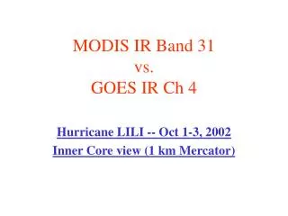
Case #1 Now, this is still using the same MODIS-GOES hybrid product, but the image to the right was taken from the GOES sensor and was valid some 17 minutes later at 0832Z. Notice that the lower resolution of the GOES instrument is not able to detect the fog along the TN Rivernearly as well as MODIS. This is one reason why a loop of the hybrid spectral difference imagery can be advantageous in operations.
Case #2 This was a unique case in which GOES imagery was indicating the presence of fog along the TN River, while the MODIS was not. Notice in this GOES image valid at 0815Z Oct 3rd, 2011, the presence of yellow pixels indicating fog along the TN River channel.
Case #2 This is the MODIS image valid at 0757Z Oct 3rd, 2011. Notice that it indicates the potential for some fog along the TN River in west TN. However, no fog is indicated along the TN River in AL. This is important for considerations for fog development at our TAF site KMSL, which is located just a few miles from the river. Often, when we see fog development along the TN River nearby, fog will develop or eventually advect over the TAF site. Here, the MODIS imagery was indicating this was not happening.
Case #2 This is a GOES visible image valid just after sunrise at 1301Z Oct 3rd, 2011. Notice the thin while line along the TN River in west TN, however notice no fog along the TN River in AL. The ASOS at KMSL in NW AL did not report fog that night. The MODIS helped to show the development of fog was not as likely there.
Case #3 ~15 minutes GOES Image valid 10 Aug 0645Z MODIS Image valid 10 Aug 0701Z The MODIS-GOES 11-3.9µm hybrid product helps in the early detection of fog in narrow valleys and demonstrates future NOAA/GOES-R capabilities.
Case #3 This GOES Vis Image valid at 1231Z, shortly after sunrise, shows the blanket of fog in the valleys of northeastern AL and southern middle TN. GOES Vis Image valid 10 Aug 1231Z