Emergency Managers Weather Information Network (EMWIN)
190 likes | 450 Vues
NOAA Direct Readout Conference April 5 th , 2011. Low Rate Information Transmission (LRIT). Emergency Managers Weather Information Network (EMWIN). High Rate Information Transmission (HRIT). Rob Wagner NOAA National Weather Service Santos Rodriguez NOAA National Weather Service

Emergency Managers Weather Information Network (EMWIN)
E N D
Presentation Transcript
NOAA Direct Readout Conference April 5th, 2011 Low Rate Information Transmission (LRIT) Emergency Managers Weather Information Network (EMWIN) High Rate Information Transmission (HRIT) Rob Wagner NOAA National Weather Service Santos Rodriguez NOAA National Weather Service Paul Seymour NOAA Satellite and Information Service
Low Rate Information Transmission Users can obtain this information with relatively low cost ground systems. LRIT is a collection of low resolution NOAA data and products, packaged into a single stream, and rebroadcast over NOAA geostationary satellites.
Low Rate Information Transmission • L-Band LRIT Specifications • GOES-11/12/13/14/15 • Frequency: 1691.0 MHz • Data Rate: 128 kbps • Modulation: BPSK • Polarization: Linear • LRIT on GOES-11 off during eclipse • Eclipse outages in spring and fall • No LRIT broadcast on GOES-12
Low Rate Information Transmission • Products • All GOES-East Visible/Infrared/Water Vapor imagery plus GOES-West IR • All GOES-West Visible/Infrared/Water Vapor imagery plus GOES-East IR • Graphic images of MSG and MTSAT • Tropical storm information • Copy of EMWIN broadcast • GOES Data Collection System broadcast • Administrative messages
Low Rate Information Transmission • Improvements • MTSAT LRIT coming soon • New products for both broadcasts • Redundant LRIT at the OSPO COOP Site • Operational test this summer after EMWIN connection is completed • Transition from GOES-11 to GOES-N/O/P • Will not affect LRIT broadcast except for actual switch-over
What is EMWIN? • The Emergency Managers Weather Information Network (EMWIN) is a low cost, priority-driven weather data broadcast service that provides one of the most robust NWS systems for public weather dissemination • EMWIN provides rapid satellite, internet and VHF radio broadcasts of: • Alerts/Watches/Warnings < 1 minute • Forecasts • Graphics, Imagery
EMWIN Assets • Large footprint • EMWIN broadcast covers over 2/3rd’s of the earth’s surface • Used internationally in the Pacific rim, Caribbean and parts of South America • Reliable • Transponders on GOES East and West for redundancy • Requires little infrastructure in a disaster, not dependent on internet or utility lines • 24/7 since 1996 with almost zero down time • L-band signal adds to reliability • Inexpensive equipment and software • No subscription satellite service. • Free software defined radio receiver application • Small form factor equipment, can even be used mobile
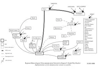
EMWIN- How it Works • Data is collected from the NWS Gateway, NOAA Weather Wire and the Internet • Assembled and prioritized • Sent to NESDIS, (Wallops CDA) where it is up-linked to the GOES satellites • Sent further east via GOES 12 • Sent further west via “Peace Sat” (NOAA donated GOES-7) in a cooperative effort between NWS Pacific Region and the Univ. of Hawaii • Sent on the internet via ip unicast • Transmitted via VHF radio (local re-broadcast) in some areas
EMWIN GOES-N Satellites • GOES N thru P changes • Data rate doubles from legacy EMWIN • Forward error correction • Offset QPSK modulation • Allows enhancement of the data stream • Coding gains used to retain current user dish size • Dedicated transponder • No eclipse outage • GOES East was replaced April 2010 • GOES West likely replaced December 2011
HRIT/EMWIN • GOES-R constellation • Combined HRIT/EMWIN transponder • Greater user/vendor base • Combined LRIT and EMWIN Broadcast/Product Suite • HRIT/EMWIN Specifications • Frequency: 1697.4 MHz Data Rate: 400 kps • Modulation: BPSK Polarization: Linear • Forward error correction • User satellite dish form factor remains small • HRIT / EMWIN Prototype Receiver • Capable of receiving HRIT/EMWIN, LRIT and EMWIN from all GOES-Series • Information available at www.goes-r.gov
HRIT/EMWIN Prototype Receiver Demonstration Tonight 5:30 Ballroom #4
Contact Information • Paul Seymour • Paul.Seymour@NOAA.Gov • 301-817-4521 • www.noaasis.noaa.gov • Rob Wagner • Robert.Wagner@NOAA.Gov • 301-713-0870 x 154 • http://www.weather.gov/emwin/ • Santos Rodriguez • Santos.Rodriguez@NOAA.Gov • 301-713-0077 • http://www.weather.gov/emwin/ • HRIT/EMWIN Information: www.goes-r.gov
BackgroundUser Transition Costs EMWIN-N • EMWIN-II user transition cost breakdown • Users with frequency stable legacy LNB system requiring only I/F adapter and receiver cost are approx. $800 • Users with legacy LNA system requiring only I/F adapter and receiver cost are approx. $1000 • Complete new system including PC costs approx. $2400
EMWIN Footprint EMWIN coverage map at 1 deg. elevation for GOES Satellites