Download
1 / 6
60 likes | 138 Vues
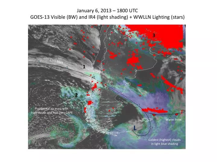
January 6, 2013 – 1800 UTC GOES-13 Visible (BW) and IR4 (light shading) + WWLLN Lighting (stars). 3. Cold front. 1. 2. Postfrontal air mass with high clouds and non-zero CAPE. Warm front. L. Coldest (highest) clouds in light blue shading. Elementos para discutir.

E N D
January 6, 2013 – 1800 UTC GOES-13 Visible (BW) and IR4 (light shading) + WWLLN Lighting (stars) 3 Cold front 1 2 Postfrontal air mass with high clouds and non-zero CAPE Warm front L Coldest (highest) clouds in light blue shading
Elementos para discutir Significativa densidad de rayos en sector post-frontal, sobre Patagonia chilena. Claro indicio de inestabilidad post-frontal: nubes Cu de gran desarrollo vertical. Análisis meteorológico (GFS) confirma inestabilidad postfrontal (CAPE>0) debido a enfriamiento en altura. Precipitaciones significativas en esta zona. Rayos en sector postfrontal en 3 clusters sobre la costa/Andes. Control topográfico o artefacto de las observaciones? Otras fuentes de datos Ausencia de rayos a lo largo del frente frío. Actividad eléctrica a lo largo del frente cálido.
January 6, 2013 – 1800 UTC GFS (6hr forecast) T950 + wind @ 1000 hPa + GOES-13 VIS
January 6, 2013 – 1800 UTC GFS (6hr forecast) surface CAPE (>40 J in light shading) + GOES-13 VIS
1 Prefrontal snd. No CAPE 3 continental snd. CAPE>>0 2 Postfrontal snd. CAPE>0
January 6, 2013 – 1800 UTC GFS (6hr forecast) surface precipitation + WWLLN Lighting (stars)