Download
1 / 36
360 likes | 516 Vues
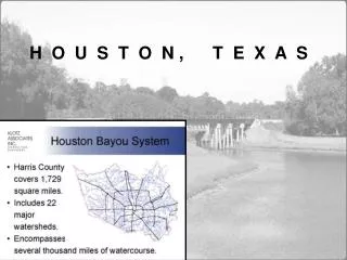
H O U S T O N , T E X A S. Watershed: area of land that drains all the streams/rainfall to a common outlet such as the outflow of a reservoir, mouth of a bay, or any point along a stream channel. WATERSHEDS & SUBAREAS. S I M I L A R S T U D I E S

E N D
Watershed: area of land that drains all the streams/rainfall to a common outlet such as the outflow of a reservoir, mouth of a bay, or any point along a stream channel. WATERSHEDS & SUBAREAS
S I M I L A R S T U D I E S T H A T R E F L E C T H O U S T O N ’ S C O N D I T I O N S ……
S a n A n t o n i o, T e x a s San Antonio Creek is, these days, more commonly called Oakland Estuary, or just the Oakland Inner Harbor, but it includes Lake Merritt. The Glen Echo Creek sub-watershed is shown in green; the Lakeshore Arm sub-watershed is in pink.
A u s t i n, T e x a s Austin, Texas shows its creeks, rivers and watersheds. Most of the running water exists southeast to the ocean
O r e g o n The Cow Creek homeland stretches across 4 major river watersheds in southwestern Oregon. It also includes the entire drainage of Cow Creek itself, which is a tributary of the South Umpqua River.
V i r g i n i a Virginia's coastal zone includes 5,000 miles of shoreline, 4 tidal rivers reaching as far as 100 miles inland, the Chesapeake Bay and Albemarle - Pamlico Sound watersheds, and the Atlantic Ocean coastline. Natural & cultural features range widely - from the wild, undeveloped beaches of the barrier islands to the "hard" shoreline of Hampton Roads' port facilities.
N e w O r l e a n s Encircled by the river, Lake Pontchartrain, bayous, swamps, marshes and wetlands, New Orleans, evolved along ridges, or "cheniers" as they were called, marked by grand Live Oak and tall Magnolia trees.
M i s si s si p pi Virginia's coastal zone includes 5,000 miles of shoreline, 4 tidal rivers reaching as far as 100 miles inland, the Chesapeake Bay and Albemarle - Pamlico Sound watersheds, and the Atlantic Ocean coastline. Natural & cultural features range widely - from the wild, undeveloped beaches of the barrier islands to the "hard" shoreline of Hampton Roads' port facilities.
G e o r g i a Map of Georgia showing the Atlanta metropolitan area counties located in the Chattahoochee River watershed.
L o w e r A l a b a m a Destination: Chicory BayouLaunch: Cloverleaf LandingDistance: 15.5 milesPace: ModerateTime: 5 hoursWeather: Humid with high temperature of 91 degrees (felt like 100+ at times). Partly cloudy with afternoon thunderstorms. Low tide - 12:54AM (.4), high – 4:20PM (1.2).
N o r t h C a r o l i n a The Savannah River forms in Lake Hartwell with the confluence of the Seneca and the Tugaloo Rivers. It drains a watershed of 10,577 square miles in Georgia, South Carolina and North Carolina and flows 300 miles through forests, agricultural lands, artificial impoundments & swamps before emptying into the Atlantic near Savannah.
M a c r o L e v e l • S i t e – 2 • T h e a t e r • D i s t r i c t • B a y o u P l a c e N
M ic r o L e v e l • S i t e – 2 • T h e a t e r • D i s t r i c t • B a y o u P l a c e PATHS: Movement is created next to the Bayou. Pedestrian flow is from Southwest to Northeast. N
M a c r o L e v e l • S i t e – 2 • T h e a t e r • D i s t r i c t • B a y o u P l a c e N
M ic r o L e v e l • S i t e – 2 • T h e a t e r • D i s t r i c t • B a y o u P l a c e EDGES: Arrows illustrate “joining” to “separation”…vice-versa. N
M a c r o L e v e l • S i t e – 2 • T h e a t e r • D i s t r i c t • B a y o u P l a c e N
M ic r o L e v e l • S i t e – 2 • T h e a t e r • D i s t r i c t • B a y o u P l a c e District-A DISTRICTS: Visibility from inside-to-outside & outside-to-inside. District-B District-C N
M a c r o L e v e l • S i t e – 2 • T h e a t e r • D i s t r i c t • B a y o u P l a c e N
M ic r o L e v e l • S i t e – 2 • T h e a t e r • D i s t r i c t • B a y o u P l a c e Illustration of intersection and/or Crossing. NODES: Spot that shows where traffic can enter & exit, as well as convergence of paths. N
M a c r o L e v e l • S i t e – 2 • T h e a t e r • D i s t r i c t • B a y o u P l a c e N
M ic r o L e v e l • S i t e – 2 • T h e a t e r • D i s t r i c t • B a y o u P l a c e LANDMAKS: Landmarks illustrate various heights & can represent unique architecture in Houston. N
N • S i t e – 2 • T h e a t e r • D i s t r i c t • B a y o u P l a c e W E Aerial View… S
N • S i t e – 2 • T h e a t e r • D i s t r i c t • B a y o u P l a c e Perspective Views…
http://en.wikipedia.org/wiki/Houston#Geography http://en.wikipedia.org/wiki/Geography_of_Houston http://ga.water.usgs.gov/edu/watershed.html http://www.museumca.org/creeks/1180-OMSAntonio.html http://kvue.iewatershed.com/print.php?pagename=ow_findYourLocalWatershed http://www.cowcreek.com/homeland/m04watersheds.html http://www.deq.state.va.us/coastal/coastmap.html http://www.iscas2007.org/norleans.htm http://www.mardigrasfun.com/html/NewOrleans/BayouStJohnLakeVista1947/NO_BayouStJohn_after_hurricane_1947.jpg http://www.embellishedcommunity.com/student-gallery.php http://www.city-data.com/township/James-Bayou-Mississippi-MO.html http://www.bccf.com/steelhead/watersheds.htm
http://www.joe.org/joe/2002june/a7.html http://www.dnr.sc.gov/news/Yr2006/nov13/nov13_drought_pic.html