Download
1 / 31
310 likes | 419 Vues
Explore the history and engineering changes in the Florida Everglades, learn about current restoration plans, constraints, and uncertainties. Discover the environmental consequences, invasive species, and the ambitious Comprehensive Everglades Restoration Plan (CERP).

E N D
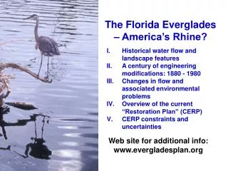
The Florida Everglades – America’s Rhine? • Historical water flow and landscape features • A century of engineering modifications: 1880 - 1980 • Changes in flow and associated environmental problems • Overview of the current “Restoration Plan” (CERP) • CERP constraints and uncertainties Web site for additional info: www.evergladesplan.org
Sawgrass plains Ridge and slough/ tree islands The Historical Everglades Kissimmee River
Hardwood hammocks Pine forest Marlprairie The Historical Everglades
Mangrove swamps Florida Bay The Historical Everglades
Events during early statehood http://everglades.fiu.edu/reclaim/timeline/index.htm 1855-58 Third Seminole War 1861-65 Civil War 1860's-1870's Railroad and canal companies face financial ruin with devaluation of confederate currency. 1881 Philadelphia millionaire Hamilton Disston negotiates to drain lands overflowed by Lake Okeechobee and the Kissimmee River in exchange for one-half the reclaimed land. 1845 Florida admitted into the Union as the 27th state. 1847-48 Engineer Buckingham Smith hired to examine and survey the South Florida wilderness, reporting on its value and feasibility for reclamation to Congress. 1850 U.S. Congress grants swamp lands to Florida for the purpose of drainage and reclamation.
Drainage History New York Times, February 18, 1881: “The reclamation of 12,000,000 acres of land, or one-third of the States of the Union, has been undertaken by a company of Philadelphia gentleman with every prospect of success...The project of reclaiming this wonderfully rich country has been talked of for years, and it has long been considered feasible by many noted engineers...The leading man in this enterprise is Hamilton Disston, a young gentleman of great business energy and ample fortune, and present head of the great saw-manufacturing firm of Henry Disston & Sons.”
NEW CHANNEL CONSTRUCTION CHANNEL DREDGING AND STRAIGHTENING FIRST LARGE SCALE DRAINAGE EFFORT IN SOUTH FLORIDA HAMILTON DISSTON CONSTRUCTION 1881-1894
ST. LUCIE CANAL CONSTRUCTED 1916 TO 1928 CALOOSAHATCHEE RIVER DREDGED AGRICULTURAL CANALS DREDGED EVERGLADES DRAINAGE DISTRICT WORKS 1905-1928 Drainage History (continued)
“River of grass” replaced (now) by sugar cane fields* and “water conservation areas” * Sugar cane is profitable to grow in Florida primarily due to the US trade embargo on Cuba
Deadly hurricanes in 1926 and 1928 caused flooding of Lake Okeechobee Fort Lauderdale, 1926 Belle Glade, 1928
Drainage History (continued) HERBERT HOOVER DIKE 1932-1938
Drainage History (continued) AREAS FLOODED IN 1947
The 1950s – 1980s CENTRAL & SOUTHERN FLORIDA (C&SF) PROJECT 1,000 miles of canals 720 miles of levees ~200 water control structures
Continued Channelization of the Lower Kissimmee River in the 1960s Lock and dam structure Straightened channel with remnant meander that is now cut off from main flow
Continued Expansion of Agriculture and Urban Areas Dramatic Change in Flows
Too wet in the water conservation areas Too dry in Everglades National Park Loss of tree islands Loss of wading and water birds Environmental Consequences
Land subsidence and loss of peat soil http://pubs.usgs.gov/circ/circ1182/pdf/12Everglades.pdf ft above sea level
Other Indicators of Ecosystem Problems • 68 plant and animal species are threatened or endangered • Over 1.5 million acres infested with invasive, exotic plants Brazilian pepper is an aggressive non-native plant. It grows as a shrub or small tree, is related to poison ivy and can grow between 10 and 40 feet tall. Its growth is dense so it prevents the growth of other vegetation.
The 1990s: Planning for the “CERP” Approved in the Water Resources Development Act of 2000 Includes more than 60 elements Will take more than 30 years to construct Will cost an estimated $7.8 billion
Urban Water Supply and Flood Control Agriculture Lake Okeechobee Invasive Species Water Quality Constraints
Principal Features and Uncertainties • Surface Water Storage Reservoirs • Aquifer Storage Recovery • Stormwater Treatment Areas • Reuse Wastewater • Seepage Management • Removing Barriers to Sheetflow • Operational Changes to Structures
Aquifer Storage Recovery (ASR) Idealized System
Existing ASR Wells in Florida (from USGS WRI Report 02-4036)
Variations in Permeability Aquifer Flow CERP ASRs will include over 300 wells each with a capacity of 5 million gallons per day Major Questions • Effects on regional groundwater flow and pressures below confining unit • Efficiency of recovery after long storage periods
Additional Questions • Fate of potential contaminants (e.g. microbes, mercury, nutrients) that are present in source water • Geochemical and biogeochemical reactions due to mixing and water rock interactions
“Pilot” projects to address these questions Most Important Question • Will recovered water be of suitable quality for the ecosystem?
But • Well designed pilot projects will require 5-10 years to yield results • Hydrogeologic conditions may limit storage options • Need for contingency planning now
If there is not enough water (or water storage) to satisfy all needs, what are the options? • Accept increased flood risk in urban areas • Condemn sugar holdings in the Everglades Agricultural Area to provide more land for surface reservoirs • Restrictions on public water supply • Allow increased fluctuations in Lake Okeechobee water levels (affecting fishing, boating and waterfowl hunting, as well as water supply for surrounding communities) • Provide less water to Everglades National Park than that required for habitat improvement