Hydrological Cycle Observing System: Focusing on Water Balance Summary Apps
50 likes | 151 Vues
Join us in bringing a big vision into focus with the World Meteorological Organization and the World Hydrological Cycle Observing System. Learn how applications can make data actionable, starting with simple tasks like Water Balance Summary Apps. Discover the power of hosting content with Information Layers and Analysis services on ArcGIS.com. Our goal is to build a community around hydrological data and empower data producers to use hosting services effectively. Let's collaborate, share knowledge, and create valuable solutions together!

Hydrological Cycle Observing System: Focusing on Water Balance Summary Apps
E N D
Presentation Transcript
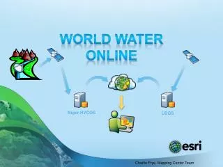
WorldWaterOnline Charlie Frye, Mapping Center Team Niger-HYCOS USGS
Jack + David = Big Vision • Bringing this big vision into focus… Start with global: • World Meteorlogical Organization (WMO: http://www.wmo.int) • World Hydrological Cycle Observing System (WHYCOS: http://www.whycos.org) • Sharper focus = Not about data • We’ve got so much data • The future is in applications that make that data useful to us and others • It always starts with one simple application: Water Balance Summary
Making Apps Work is How We Learn • Keep Focusing… • Learn how to host content that drive applications: • Information Layers • Query & Analysis services • Start with Simple application that does one useful task • Get people to use it and as for more (be user-driven) • More tasks • Greater resolution, larger scales, national through local content • “Information is more valuable when it’s accessible.”
Hosted on ArcGIS.com • Our challenge is to figure out how to host layers and services • Monthly content summaries drive initial applications • Build an online community and “home place” for world hydro • Long term: Shift to facilitating data producers to use ArcGIS.com hosting services • Find impedances and flatten them by sharing understanding • Get real • do things together • leading in ways that the community finds valuable
Thank You • Please provide us feedback on this workshop: Evaluations are online:www.esri.com/sessionevals