Download
1 / 7
70 likes | 249 Vues
Editing has been performed to remove artifacts and interpolate over failed regions. DEM used to orthorectify image bands False color VNIR composite draped over DEM for 3-D visualization. Glacier Mass Balance Studies.

E N D
Editing has been performed to remove artifacts and interpolate over failed regions. • DEM used to orthorectify image bands • False color VNIR composite draped over DEM for 3-D visualization Glacier Mass Balance Studies • ASTER data being used to predict response of glacier systems to climate change • Glacier boundary outlines (using GLIMSView) combined w/ ASTER-derived DEM to get hypsography • Hypsography plus measurements from benchmark glacier used to define mass balance as function of ELA for entire glacier system
Mask DEM using ice outlines • Compute histogram of elevations Glacier Mass Balance Studies • ASTER data being used to predict response of glacier systems to climate change • Glacier boundary outlines (using GLIMSView) combined w/ ASTER-derived DEM to get hypsography • Hypsography plus measurements from benchmark glacier used to define mass balance as function of ELA for entire glacier system
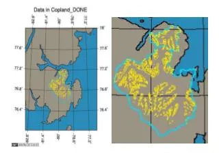
Digitizing outlines w/ GLIMSView • Exports data in format specified for ingest into GLIMS database at NSIDC Glacier Mass Balance Studies • ASTER data being used to predict response of glacier systems to climate change • Glacier boundary outlines (using GLIMSView) combined w/ ASTER-derived DEM to get hypsography • Hypsography plus measurements from benchmark glacier used to define mass balance as function of ELA for entire glacier system
Hypsography compared to previous field survey (Kuzmichenok, 1977) Glacier Mass Balance Studies • ASTER data being used to predict response of glacier systems to climate change • Glacier boundary outlines (using GLIMSView) combined w/ ASTER-derived DEM to get hypsography • Hypsography plus measurements from benchmark glacier used to define mass balance as function of ELA for entire glacier system
The “Template” Method • Field measurements of benchmark glacier used to find annual mass balance as function of accumulation area ratio (AAR) • This relationship is assumed to apply to all glaciers in a region sharing similar climate, terrain, etc. • Integral of area vs. elevation curve gives AAR as function of equilibrium line altitude (ELA) • Thus, we can get mass balance as function of ELA for any glacier, using its hypsography