Download
1 / 20
200 likes | 306 Vues
This tool by Carolina Environmental Program UNC Chapel Hill allows users to create emission surrogates efficiently without a Geographic Information System. It computes spatial surrogates for precise emissions distribution, operates on UNIX and Windows, and supports popular map projections. The software enables mapping county-level emissions onto grid cells used by air quality models with customizable weight attributes. The provided GRIDDESC file aids in defining the output grid, while a user-friendly GUI facilitates grid visualization. Users can generate surrogates accurately and output them in various formats. The tool's versatile functionality and free accessibility make it ideal for emission inventory tasks.

E N D
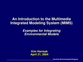
The MIMS Spatial Allocator: A Tool for Generating Emission Surrogateswithout a Geographic Information System* Alison M. Eyth, Kimberly Hanisak Carolina Environmental Program University of North Carolina at Chapel Hill October 28, 2003 *This material was originally presented at the Emission Inventory conference in San Diego, CA on May 1, 2003 Carolina Environmental Program UNC Chapel Hill
Multimedia Integrated Modeling System (MIMS) • Program sponsored by EPA Office of Research and Development • Successor to Models-3 Computer Framework • Components: • Java-based computer framework for running multimedia (and other complex) models • Spatial allocator, Analysis engine, etc. • Framework contains tool for designing/visualizing air quality model grids (also developed by MCNC) • Free to users • mostly open source components, but uses some proprietary (but free) libraries • http://www.epa.gov/asmdnerl/mims Carolina Environmental Program UNC Chapel Hill
MIMS Spatial Allocator • Initially developed at MCNC • Most of MCNC EMC is now at UNC Chapel Hill • New version provided in March with optimizations, new features, and bug fixes • Additional changes provided in October • Operating modes: • Generates spatial surrogates that can be input to SMOKE • Change map projection of Shapefiles • Performs other types of spatial allocation • Aggregate county data to state data • Convert between county data and gridded data Carolina Environmental Program UNC Chapel Hill
Benefits of Spatial Allocator • Zero cost makes surrogate generation accessible to more people • Focused purpose of software makes it easier to use to create surrogates than a GIS • Runs on UNIX and Windows • Input data in commonly used ESRI Shapefile format • Output Surrogates • Computed for regular grid (but could support adaptive grids) • Written in SMOKE format (but other formats could be added) • Supported map projections include Universal Transverse Mercator (UTM), Lambert Conformal, and Latitude-Longitude Carolina Environmental Program UNC Chapel Hill
What are Spatial Surrogates? • Used to map county level emission inventory data into the rectangular grid cells used by air quality models • For example, dry cleaning emissions values may be available for a county, but CMAQ requires them by grid cell • Surrogate value is the fraction of the emissions for a county that should be apportioned to a grid cell • emis(GC) = srg(Cty,GC) * emis(Cty) • Surrogates allow for more spatial accuracy in emissions distribution than assuming a uniform spread over the county • E.g. Applying a population surrogate causes higher levels emissions to be placed in the grid cells that cover more densely populated parts of the county Carolina Environmental Program UNC Chapel Hill
Computing Spatial Surrogates • Surrogates are computed using a fraction • Numerator = the value of a weight attribute in the area of intersection between the grid cell and county • Denominator = the value of a weight attribute in the entire county • Sum of surrogates values for each county within the grid should be 1 • Weight attributes can be based on objects that are points, lines, or polygons (e.g. port berths, railroads, population) • Sometimes use number of points, length, or area for weight Carolina Environmental Program UNC Chapel Hill
Overall Surrogate equation Where Wt(x) = value of weight attribute for x, Cty = County, GC = grid cell, wp = weight polygon Carolina Environmental Program UNC Chapel Hill
Impact of Weight Attribute on Surrogate Values Carolina Environmental Program UNC Chapel Hill
Using the GRIDDESC File to Specify the Output Grid ! coords ‑‑line: name; type, P‑alpha, P‑beta, P‑gamma, xcent, ycent 'LAT_LON' 1, 0.0D0, 0.0D0, 0.0D0, 0.0D0, 0.0D0 'UTM_10' 5, 10.0D0, 0.0D0, 0.0D0, 0.0D0, 0.0D0 'LAM_40N105W' 2, 30.0D0, 60.D0,‑105.D0,‑105.D0, 40.D0 ' ' ! end coords. Grid name;xorig,yorig,xcell,ycell,ncols,nrows,nthik 'EPAW36_56X78' 'LAT_LON' , ‑127.0D0, 26.0D0, 0.5000D0, 0.33333D0, 56, 78, 1 'NEW_YORK' 'UTM_18', 480.0D3, 4440.0D3, 5.0D3, 5.0D3, 58, 46, 1' 'DENVER8_34X45' 'LAM_40N105W', ‑116.D3, ‑188.D3, 8.D3, 8.D3, 34, 45, 1 Carolina Environmental Program UNC Chapel Hill
Visualizing Grids with MIMS Grid Family GUI Carolina Environmental Program UNC Chapel Hill
Example Windows .bat for Ports Surrogate set MIMS_PROCESSING=SURROGATE set POLY_OUT_TYPE=RegularGrid set DATA=C:\surrogates\inputs set GRIDDESC=%DATA%\GRIDDESC.txt set GRID=M_08_99NASH set POLY_DATA_TYPE=ShapeFile set POLY_DATA=%DATA%\cnty_tn set ATTR_DATA_ID=FIPS_CODE set POLY_WEIGHT_TYPE=ShapeFile set POLY_WEIGHT=%DATA%\tn_ports set ATTR_WEIGHT=BERTHS set CATEGORY_WEIGHT=4 set SURROGATE_FILE=C:\surrogates\output\srg_ports.%GRID%.txt C:\surrogates\bin\mims_spatial.exe Carolina Environmental Program UNC Chapel Hill
Quality Assurance Options for Surrogates • OUTPUT_SRG_NUMERATOR: writes surrogate numerator as a comment in output file • OUTPUT_SRG_DENOMINATOR: writes surrogate denominator as a comment in output file • MIMS_QASUM: writes a running sum of the surrogate values for each county in output file (should sum to 1) • POLY_OUT_NAME: creates a shape file (and .csv file) that contain sums of the surrogate numerators for each grid cell (gridded version of weight attribute Carolina Environmental Program UNC Chapel Hill
Excerpt of Surrogate Output with Quality Assurance Options On Cat County Col Row Srg value Numerator Denominator QA Sum 4 47011 44 20 1 ! 8 8 1 4 47037 19 28 0.2 ! 2 10 0.2 4 47037 20 27 0.3 ! 3 10 0.5 4 47037 20 28 0.3 ! 3 10 0.8 4 47037 21 29 0.2 ! 2 10 1 4 47039 6 18 1 ! 3 3 1 5 47027 32 34 0.491036 ! 12917.80 26307.3 0.49104 5 47027 32 35 0.005787 ! 152.24 26307.3 0.49682 5 47027 33 35 0.338548 ! 8906.28 26307.3 0.83537 5 47027 33 36 0.164629 ! 4330.96 26307.3 1 Carolina Environmental Program UNC Chapel Hill
GIST Visualization of Airport Surrogate (Weight = Count) Carolina Environmental Program UNC Chapel Hill
GIST Visualization of Port Surrogate (Weight = Berths) Carolina Environmental Program UNC Chapel Hill
Specifying Map Projections and Ellipsoids • PROJ.4 library is used (http://www.remotesensiong.org/proj) • Supports most map projections • Lambert conformal example: setenv DATA_POLY_MAP_PRJN "+proj=lcc,+lat_1=33,+lat_2=45,+lat_0=40,+lon_0=‑97“ • UTM example: setenv WEIGHT_POLY_MAP_PRJN "+proj=utm,+zone=17“ • Ellipsoid examples: • setenv WEIGHT_POLY_ELLIPSOID=+GRS80 • setenv WEIGHT_POLY_ELLIPSOID=+a=6378137.0,+rf=298.2572 Carolina Environmental Program UNC Chapel Hill
Converting the Map Projection of Shapefiles #!/bin/csh -f setenv MIMS_PROCESSING CONVERT_SHAPE setenv POLY_DATA_TYPE ShapeFile setenv POLY_DATA $argv[1] # no extension setenv POLY_OUT_TYPE ShapeFile setenv POLY_OUT_NAME $argv[2] # no extension setenv DATA_POLY_MAP_PRJN "+proj=lcc,+lat_1=33,+lat_2=45,+lat_0=40,+lon_0=‑97" setenv DATA_POLY_ELLIPSOID +WGS84 setenv OUTPUT_POLY_MAP_PRJN LATLON setenv OUTPUT_POLY_ELLIPSOID SPHERE /apps/mims_spatial/bin/mims_spatial.exe Carolina Environmental Program UNC Chapel Hill
Software Implementation • Software is written in C • Blocks of code to perform specific tasks that are reused for different operating modes • First read data (then weight) polygons & convert map projection to output projection • Next compute intersection of weight and data polygons (then of weight-data polygons with grid polygons) • Then compute surrogates • Numerator = sum of weight for each county and gc • Denominator = sum of weight for each county • Public domain libraries used • PROJ.4 for map projection conversions • Shapelib for reading / writing shapefiles • Generic Polygon Clipper for polygon intersection Carolina Environmental Program UNC Chapel Hill
Limitations • Currently only SMOKE-ready output • Output assumed to be on sphere • Line-based inputs must be “dissolved” at the county boundaries Carolina Environmental Program UNC Chapel Hill
Future Directions • Produce biogenic inputs for SMOKE • Easier conversion between county and gridded data • Generalize spatial allocation to support more forms of regridding • Create surrogates for adaptive and other non-regular grids • Further reduce memory usage to support use of larger data sets (~ 1 GB) Carolina Environmental Program UNC Chapel Hill