Download
1 / 33
330 likes | 545 Vues
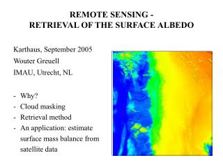
REMOTE SENSING - RETRIEVAL OF THE SURFACE ALBEDO. Karthaus, September 2005 Wouter Greuell IMAU, Utrecht, NL. Why? Cloud masking Retrieval method An application: estimate surface mass balance from satellite data. WHY ?.

E N D
REMOTE SENSING - RETRIEVAL OF THE SURFACE ALBEDO Karthaus, September 2005 Wouter Greuell IMAU, Utrecht, NL • Why? • Cloud masking • Retrieval method • An application: estimate surface mass balance from satellite data
WHY ? (Surface) albedo = fraction of short-wave radiation reflected by the surface Important for surface mass balance: Net short-wave radiation dominates energy balance Large variations Positive feedback between albedo and mass balance Spatial variations cannot be measured at surface Satellite data But: conversion of measured signals into albedo can cause considerable errors
SATELLITE NARROWBANDS Spectral response: no block shape !
DATA PROCESSING • geolocation • cloud mask • conversion of signal into albedo
CLOUD MASK Difficult over snow and ice Reason: albedo of clouds is similar to that of the surface temperature of low clouds is similar to that of the surface Conclusion: sensor with band around 1.64 µm most suitable But: no such sensor available for AVHRR and MISR Method: use (multiple) thresholds
CALIBRATION OF SATELLITE SENSORS Why? Because of post-launch degradation of sensors. Two methods 1) On-board: by measurement of solar radiation reflected from a panel with known reflectance 2) Ground target by measurement of radiance reflected by a ground target with constant optical properties (e.g. desert, dry-snow on polar ice sheets)
ABSORPTION AND SCATTERING - ATMOSPHERE Relevant processes: Absorption: mainly by ozone and water vapour; little by aerosols Scattering: gas molecules (Rayleigh scattering), aerosols
ATMOSPHERIC CORRECTION Aim: calculate the surface albedo (as) as a function of the planetary albedo (ap) is a function of: aerosols, H2O, O3 solar zenith angle (qs) view zenith angle (qv) elevation (z) Usual approach: calculate ap with a radiative transfer model for a (large) number of as, aerosol loads, H2O amounts, etc. Store results in a Look Up Table (LUT), which is used during the retrieval.
ANISOTROPIC REFLECTION AT THE SURFACE isotropic reflection: intensity of reflected radiation does not vary with the direction of reflection Lambertian surface reflects radiation isotropically Snow and ice reflect radiation anisotropically Why important ? Satellite measures reflected radiation from a single direction (radiance), but we are interested in all the reflected radiation (flux) Correction needed! Directional distribution of the reflected radiation is described by functions called Bi-directional Reflectance Distribution Functions (BRDFs)
CO-ORDINATE SYSTEM BRDF s solarzenith angle zenith angle azimuth angle
EXAMPLE OF A MEASURED BRDF TM2 (green light); solar zenith angle =50˚; albedo = 0.52 Zenith view angle of 75˚ (90˚ = horizontal) = 180˚ forward scattering = 0˚ Azimuth direction of sun = backward scattering Nadir = Straight down
NARROWBAND TO BROADBAND (NTB) CONVERSION narrowband: spectral band in which the satellite sensor is sensitive to radiation broadband: entire solar spectrum would not be necessary if the albedo was constant with wavelength would have been easy if the narrowbands covered the entire broadband: : broadband albedo i: the narrowband albedo in band i Si: incoming solar radiative flux in band i.
BAND ALBEDO MEASUREMENTS BAND ALBEDO MEASUREMENTS
EQUATION FOR NTB CONVERSION bb = 0.539 TM2 + 0.166 TM4 ( 1 + TM4 ) Solution: develop equations from simultaneous and coincident measurements of narrowband and broadband albedos
RETRIEVAL METHOD converts satellite counts into surface albedo
ACCURACY RETRIEVAL METHOD Weakest processing steps retrieval method: insufficient knowledge BRDFs of snow and ice uncertainty in calibration coefficients More accurate processing steps of the retrieval method: NTB conversion 2) atmospheric correction in relatively dry and clean polar and high-mountains atmosphere
SURFACE ALBEDO GREENLAND Surface albedo derived from AVHRR data western margin of the Greenland ice sheet 16 July 1995
BASIC IDEA OF THE METHOD B: mean annual surface mass balance <Qabs,sw>: potential absorbed short-wave radiative flux I0: extraterrestrial incoming short-wave radiative flux : satellite-derived surface albedo (glacier mean) day 1 - day 2: beginning and end of ablation season
WHY COULD METHOD BE SUCCESSFUL? • lower albedo more melt; absorbed short-wave radiation largest contribution to melt • more melt lower albedo • less accumulation lower albedo
CONVERSION INTO ENERGY BALANCE EQUATION AND THEN INTO MASS Add transmission of the atmosphere (tatm): Add long-wave and turbulent fluxes (Q0): Convert energy into mass (Lf is latent heat of fusion):
RELATION SATELLITE-DERIVED WITH MEASURED MASS BALANCE Mean 13 years: Measured: -1202 mm w.e. Satellite: -1142 mm w.e. Interannual variability (standard deviation): Measured: 366 mm w.e. Satellite: 395 mm w.e.
SUM UP • Why • Cloud masking • Retrieval method • An application: estimate surface mass balance from satellite data
CLOUD MASK (2) Scheme developed for AVHRR data Antarctica: multiple tests; if cloudy according to one test, then pixel is cloudy
CLOUD MASK (3) • Comments: • a single test is not enough • each test has physical basis • threshold values are variable in space and are subjectively chosen • combination of tests is subjectively chosen • - low clouds over snow and ice remain difficult to detect
ALBEDO OF A STABLE TARGET FROM AVHRR Dry-snow area at top of Greenland ice sheet NOAA 14 NOAA 11 NOAA 16
EXPERIMENTAL SET UP TO MEASURE BRDFs pyranometers measure flux (irradiance) pyrheliometers measure radiance