Sources of digital map data
160 likes | 366 Vues
Sources of digital map data. Ordnance Survey Digital Data from DIGIMAP. Raster data also available. Georeferenced for use in a GIS. Historic OS mapping. Digimap Classic. Digimap Carto. Digimap Download. Digital mapping data for a user-specified area. Raster data can also be downloaded.

Sources of digital map data
E N D
Presentation Transcript
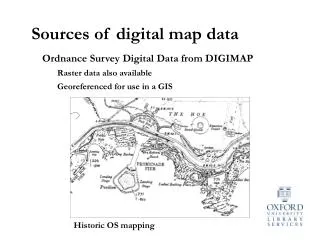
Sources of digital map data Ordnance Survey Digital Data from DIGIMAP Raster data also available Georeferenced for use in a GIS Historic OS mapping
Digimap Download Digital mapping data for a user-specified area Raster data can also be downloaded Digital mapping data cannot be viewed directly – special software is required
Maps and data – using a GIS A GIS (Geographic Information System) is a computer program which enables the creation, editing and viewing of spatial data Spatial data relates to real world objects – places, roads, rivers, trees… A GIS is spatially aware – it works with real world coordinates, distances and areas … and it creates maps!
MAPINFO - a GIS and digital mapping tool MapInfo is a professional and fully functional mapping program It is site licensed by the University It can be used by all departments and university members It can be installed on any desktop or laptop PC MapInfo workstations are available in the Bodleian Map Room
Mapping spatial data Tables of data can be combined to create a map Towns table Roads table Lakes table Rivers table