Download
1 / 9
100 likes | 361 Vues
NWS Operations Proving Ground November 2012 Update. Proving Ground All Hands Teleconference 13 November 2012 Chad Gravelle. My Position – NWS Operations Proving Ground GOES-R Liaison. Continues to evolve and is twofold. NWS OPG Science Coordinator and GOES-R Liaison

E N D
NWS Operations Proving GroundNovember 2012 Update Proving Ground All Hands Teleconference 13 November 2012 Chad Gravelle
My Position – NWS Operations Proving Ground GOES-R Liaison • Continues to evolve and is twofold. • NWS OPG Science Coordinator and GOES-R Liaison • NWS Forecast Office GOES-R Liaison • Being the bridge between all CIs (CIRA, SPoRT, CIMSS) and NWS Forecast Offices/Regional Headquarters. • Assist WFOs with product training and evaluations. • Assist CIs with gathering feedback from product demonstrations. • Document GOES-R WFO evaluations (formal) for the GOES-R Program Office for their Annual Report. • “Help me...help you.”
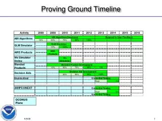
NWS Operations Proving Ground Status • Announcement of Opportunity • 1st Quarter 2013 • Target NOAA Testbeds and Proving Grounds • Looking for products/tools that have been rigorously assessed. • AWIPS 2 System – Almost complete (waiting for Network Storage) • Assist CIs with A2 product transition • AWIPS 1 System – Decommissioned from Aviation Weather Center
NWS Central Region Fog / Low Stratus (FLS) Demonstration • 1 August – 31 December 2012 • Participating NWS Offices: DMX, EAX, IND, JKL, LMK, LSX, MQT, RIW • GOES-R Fog and Low Stratus Products (M. Pavolonis) • CIRA WRF Synthetic 10.35-3.9 µm Forecasts • 45 survey responses as of today. • Overall, how likely are you to use the GOES-R products again when diagnosing FLS? GOES-R FLS CIRA WRF 10.35-3.9 µm Fcsts
NWS Tampa Bay, FL (TBW) Pilot Project and GOES-R • The NWS pilot projects are a way to test and evaluate key concepts in an operational environment and start forward down the path of improving products and services. • The • The purpose of the Tampa Bay Area Pilot Project is to enable improved decision support in a vulnerable ecosystem. • One of the many objectives in their plan is to "Evaluate the GOES-R Fog Product in coordination with the GOES-R Proving Ground". • TBW will evaluate the GOES-R FLS products formally between 11/1/2012 and 5/1/2013. • Feedback through an online survey.
NWS Tampa Bay, FL (TBW) Pilot Project and GOES-R Another example: http://fusedfog.blogspot.com/2012/11/ifr-conditions-under-cirrus-in-florida.html IFR Probabilities Legacy Fog Difference Product
NWS Eastern Region GOES-R Demonstrations • GOES-R FLS (GSP, PHI) • CIMSS Cloud-top Cooling (CAE, RAH, RLX, GSP; formal evaluation) • ERH Contact: Dave Radell • Collaborated with Dave and algorithm developers from CIMSS to develop post-mortem surveys for the demonstrations. • Goal of Future ER Formal Demonstrations: • Better communication between ER and GOES-R Proving Ground
JPSS Suomi NPP VIIRS Day/Night Band (DNB) • Delivery to NWS WFOs – coordinating with Kathy Strabala and William Straka (CIMSS). • VIIRS DNB AWIPS 1 configuration and display instructions for NWS WFOs were completed by Jordan G. and Kaba B. • Successfully transferred into operations at NWS Monterey, CA (MTR) • Some preliminary feedback... Last week on our mids we issued some Dense Fog Advisories and Nowcasts. The fog was very shallow upon its return after an offshore wind event. We had numerous surface obs (ASOS sites, etc) reporting the fog. However, for us the night time pass usually comes at a good time (say between 8-10z). The resolution gave us the confidence upon actually seeing where the fog was to issue (and not issue) for certain zones. It also gave us increased confidence to issue a Marine Dense Fog Advisory for San Francisco Bay, a spot where we don't have real obs over the water in general. So, as is often the case its just another tool to help increase or decrease confidence. In situations where the skies are clear and the fog/cloud deck is shallow it can really pinpoint things for us along the coast where the marine layer intrusions can vary depending on exact location, valley and layer depth. - Forecaster at NWS MTR
Over the Next Few Months • Wrap up NWS CR FLS Demonstration • West Coast FLS Initiative – HNX and MTR • Assist Matt Foster (NWS CRH) with FLS transition to AWIPS 2. • Assist Kathryn M. in documenting GOES-R products in WFOs. • AMS Presentation/Preprint - 16th Conference on Aviation, Range, and Aerospace Meteorology • Joint JPSS/GOES-R Fire Experiment - BOU • CIMSS Cloud-top Cooling research using GOES-14 SROS