Download
1 / 9
90 likes | 224 Vues
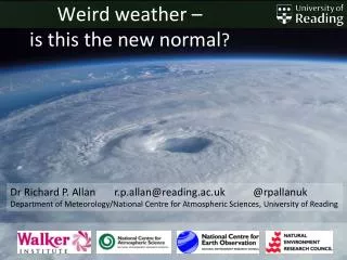
Weird weather – is this the new normal ?. Dr Richard P. Allan r.p.allan@reading.ac.uk @ rpallanuk Department of Meteorology/National Centre for Atmospheric Sciences, University of Reading . Europe 2003 extreme summer temperature: normal by 2040s, cool by 2060s?.

E N D
Weird weather – is this the new normal? Dr Richard P. Allan r.p.allan@reading.ac.uk @rpallanuk Department of Meteorology/National Centre for Atmospheric Sciences, University of Reading
Europe 2003 extreme summer temperature: normal by 2040s, cool by 2060s? European summer temperature change (oC) -2 0 2 4 6 8 1900 1950 2000 2050 2100 70 70 Stott et al. (2004) Nature
Intensification of rainfall • Atmospheric moisture increases with warming (observations/basic physics) • Moisture is the fuel for heavy rainfalle.g. Lavers et al. (2011) • Observations, physics and detailed simulations indicate intensification of rainfall with warming e.g. Allan & Soden (2008)
The rich get richer… • Warming enhances moisture flows from dry regions to wet regions • Physics, observations and simulations indicate wet regions will become wetter and dry regions increasingly drier • More flooding and more drought likely, especially across the tropics Precipitation Change (%) IPCC (2007) Observations Models Wet region Precipitation Change (%) Dry region Liu & Allan (2013) submitted
Weather patterns 1. Air is warmer closer to the tropics (air expands) than at the poles (air contracts). This generates a poleward flow of air high up in the atmosphere 2. The Earth spins: the surface moves quicker near the equator than at higher latitudes. So poleward-flowing air is deflected to the east(direction of spin) WARM COLD 3. This high altitude (5-7km) fast moving ribbon of air is called the jet stream. It steers weather systems over or away from the UK.
Arctic Ice, ocean temperature and the jet stream 4. Changes in this temperature difference between equator and pole can alter the position, strength and characteristics of the jet stream. Both natural and human-caused effects influence our weather patterns
How will jet stream &winter storm characteristics alter in the future? • Shifts in the jet stream unclear (left) • Precipitation intensity (bottom left) &number of Atmospheric River events (below) likely to increase with warming – – + – – + + + Zappa et al. (2013) J. Climate Lavers et al. submitted
Weird weather – is this the new normal? • Attributing every extreme weather event to climate change is not useful • However, the environment, from which our weather takes shape, has changed significantly since the 1970s • Storms, jet streams, tropical cyclones and other weather phenomena are slightly different than they would have been without global warming • The “normal” is changing…