Download
1 / 11
110 likes | 325 Vues
The Impact of Dropwindsonde and Supplemental Radiosonde Observations on GFS Track Forecasts of Hurricane Irene. Michael J. Brennan NOAA/NWS/NCEP National Hurricane Center, Miami, Florida Sharanya J. Majumdar RSMAS Division of Meteorology and Physical Oceanography, Miami, Florida

E N D
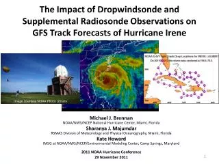
The Impact of Dropwindsonde and Supplemental Radiosonde Observations on GFS Track Forecasts of Hurricane Irene Michael J. BrennanNOAA/NWS/NCEP National Hurricane Center, Miami, Florida Sharanya J. MajumdarRSMAS Division of Meteorology and Physical Oceanography, Miami, Florida Kate HowardIMSG at NOAA/NWS/NCEP/Environmental Modeling Center, Camp Springs, Maryland 2011 NOAA Hurricane Conference 29 November 2011 Image courtesy NOAA Photo Library
Motivation • Irene was one of the most sampled tropical cyclones in history in terms of observations in the inner core, in the near-storm environment, and in the upstream environment • 10 synoptic surveillance missions were flown from 23–27 August • Supplemental radiosondes were requested starting at 18Z 22 August in the Southeast and Mid-Atlantic, and then expanded to cover all of the CONUS from the Rockies eastward at 06Z 25 August Radiosonde coverage at 18Z 25 August What impact did these data have on model track forecasts?
Methodology • Rerun the GSI data assimilation scheme withholding all dropsonde or 06/18Z radiosonde data • Rerun the GFS from the new analysis • Compare forecast track from experimental runs withholding data to the operational GFS
Operational GFS Overview • Overall the operational GFS performed very well for Irene with average track forecast errors smaller than OFCL GFS forecast tracks starting 23 August
Operational GFS Trends22 August 18Z 12Z 06Z • 00Z run had a left bias, bringing the center close to north Florida and into southeast Georgia • 06Z run shifted eastward, showing landfall in North Carolina and New Jersey • 12Z run was even farther east and closest to the best track through day 5 • 18Z run shifted to the left of the best track through day 5, but was closer to observed track into New Jersey and New York • First supplemental raobs began at 18Z on this day 00Z
Operational GFS Trends23 August • 00Z run was very close to the best track through North Carolina, but too far east afterward • 06Z, 12Z, and 18Z runs were all east of the best track north of the Bahamas, keeping the center over or east of the Outer Banks and showing landfall in eastern Long Island or southern New England • First dropsonde mission at 00Z this day 00Z 12Z 06Z 18Z
Preliminary Results Impact of dropsondes on GFS track For both cycles the dropsondes had a small but positive impact on the GFS track forecast, especially at days 3-5 00Z 23 August 2011 cycle 12Z 23 August 2011 cycle
Preliminary Results Impact of dropsondes on GFS track • 00Z 23 August cycleDropsonde data appears to have resulted in a slightly stronger ridge north of Irene through 48 h, which likely resulted in a more westward track • GFS track forecast with dropsondes is slightly closer to the coast, with an almost perfect landfall location in North Carolina (albeit too slow) • GFS forecast without dropsondes kept Irene farther offshore of North Carolina GFS OperationalGFS Minus Drops
Preliminary Results Impact of dropsondes on GFS track • Without dropsondes, the GFS forecast track would have shifted eastward at both 00Z and 12Z on 23 August • Forecast from 12Z 23 August cycle already had an eastward bias relative to observed track, which would have been even more severe without the dropsondes
Preliminary ResultsImpact of 06/18Z radiosondes on GFS track (21 cycles) Small improvement on average with 06/18Z rawindsonde data at all forecast lead times through 5 days GFS without 06/18Z rawindsondes Operational GFS
Future Work • Additional runs and results pending for dropsonde data denial • Examine trends in individual forecast cycles for radiosonde data denial • Quantify combined impact of supplemental observations (radiosondes+dropsondes) • Ensure operational GFS re-runs are done on the same computer as experiments to avoid any computational differences