Download
1 / 1
10 likes | 154 Vues
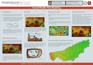
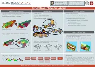
Henrik Blunck University of Aarhus. 8. 72. 9. 7. 7. 75. 4. 71. 5. 74. 73. 3. 6. 25. 1. 24. 21. 2. 2. 27. 26. 22. 23. Watershed decomposition . Digital elevation map. Pfafstetter labels. USGS (manually). Overlay. Lars Arge, University of Aarhus

E N D
Henrik Blunck • University of Aarhus 8 72 9 7 7 75 4 71 5 74 73 3 6 25 1 24 21 2 2 27 26 22 23 Watershed decomposition Digital elevation map Pfafstetter labels USGS (manually) Overlay Lars Arge, University of Aarhus Herman Haverkort, TU Eindhoven Andrew Danner, Swathmore College Norbert Zeh,, Dalhousie University • TerraSTREAM: Pfafstetter Labeling • Watershed decomposition • Watershed decomposition is a fundamental task in terrain analysis • Watershed of a river = area which drains to the river • Terrain dividable into (hierarchy) of watersheds • A river’s watershed can be subdivided into the watersheds of the river‘s tributaries • Pfafstetter labels • Identify main river • Find the 4 largest tributaries (orange) • Label tributaries (even) and interbasins (odd) • Recursively label all tributaries and interbasins • “Sanity check”: Pfafstetter decomposition “matches” manually • constructed watershed decompositions I/O-efficient algorithm • Modern terrain data is massive I/O-efficient Pfafstetter labeling algorithms needed • We develop I/O-efficient algorithm by exploiting • Terrain decomposable into rivers, i.e. into tributaries • Tributaries form a tree • Rivers can be labeled individually • Label prefixes can be “forwarded” to tributaries I/O-efficient algorithm Watershed decomposition Pfafstetter labels Current and future work • Current and future work • Watershed queries: Retrieval (and decomposition) of watershed for individual user-specified location • Meaningful labeling along coast lines, e.g., label the coastal watersheds independently or as tributaries of the “coastal river” + = Subdivision of a watershed Independent costal watersheds Connected coastal watersheds References [1] L. Arge, A. Danner, H. Haverkort, and N. Zeh. I/O-Efficient Hierarchical Watershed Decomposition of Grid Terrain Models. In Proc. 12th Intl. Symp. on Spatial Data Handling, SDH, 2007. [2] K. L. Verdin and J. P. Verdin. A topological system for delineation and codification of the Earth's river basins. Journal of Hydrology, 218, 1-12, 1999. Integration into TerraSTREAM MADALGO – Center for Massive Data Algorithmics, a Center of the Danish National Research Foundation